Geolocate

Jharkot topographic map

Interactive map

Click on the map to display elevation.

About this map

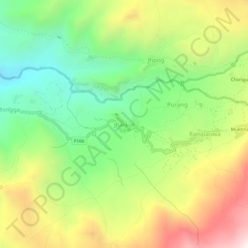
Name: Jharkot topographic map, elevation, terrain.

Location: Jharkot, Barhagaun Muktikhsetra, मुस्ताङ, Gandaki, 33100, Népal (28.79771 83.82974 28.83771 83.86974)

Average elevation: 3,653 m

Minimum elevation: 3,161 m

Maximum elevation: 4,330 m

Other topographic maps

Click on a map to view its topography, its elevation and its terrain.

Barhagaun Muktikhsetra

Népal > Gandaki > मुस्ताङ

Barhagaun Muktikhsetra, मुस्ताङ, Gandaki, 33100, Népal

Average elevation: 4,743 m

Dhakmar

Népal > Gandaki > मुस्ताङ

Dhakmar, Dalome, मुस्ताङ, Gandaki, Népal

Average elevation: 3,952 m

Kāgbeni

Népal > Gandaki > मुस्ताङ

Kāgbeni, Barhagaun Muktikhsetra, मुस्ताङ, Gandaki, Népal

Average elevation: 3,101 m

लोमान्थाङ

Népal > Gandaki > मुस्ताङ

लोमान्थाङ, मुस्ताङ, Gandaki, Népal

Average elevation: 4,949 m

Muktinath

Népal > Gandaki > मुस्ताङ > Ranipauwa

Muktinath, Barhagaun Muktikhsetra-01, Ranipauwa, Barhagaun Muktikhsetra, मुस्ताङ, Gandaki, 33100, Népal

Average elevation: 3,965 m