
Kano State topographic map
Interactive map
Click on the map to display elevation.
About this map
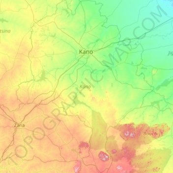
Name: Kano State topographic map, elevation, terrain.
Location: Kano State, Nigeria (10.54336 7.67517 12.60460 9.36031)
Average elevation: 546 m
Minimum elevation: 364 m
Maximum elevation: 1,178 m
Other topographic maps
Click on a map to view its topography, its elevation and its terrain.
Bakura Tureta Native Area Forest Reserve
Nigeria > Zamfara State > Bakura > Danmanau
Average elevation: 346 m
Shuwari Low-Cost
Nigeria > Borno > Damboa > Damboa Central > Shuwari Low-Cost
Average elevation: 392 m