
Tauranga City topographic map
Interactive map
Click on the map to display elevation.
About this map
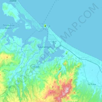
Name: Tauranga City topographic map, elevation, terrain.
Location: Tauranga City, Bay of Plenty, New Zealand (-37.77056 176.07411 -37.62409 176.41504)
Average elevation: 55 m
Minimum elevation: -1 m
Maximum elevation: 546 m
Other topographic maps
Click on a map to view its topography, its elevation and its terrain.
Tahawai
New Zealand > Bay of Plenty > Western Bay of Plenty District
Tahawai, Western Bay of Plenty District, Bay of Plenty, 3129, New Zealand
Average elevation: 41 m
Waiotapu Village
New Zealand > Bay of Plenty > Rotorua Lakes District
Waiotapu Village, Rotorua Lakes District, Bay of Plenty, New Zealand
Average elevation: 438 m
Rotorua
New Zealand > Bay of Plenty > Rotorua Lakes District
Rotorua, Rotorua Lakes District, Bay of Plenty, 3010, New Zealand
Average elevation: 435 m
Katikati
New Zealand > Bay of Plenty > Western Bay of Plenty District
Katikati, Western Bay of Plenty District, Bay of Plenty, 3129, New Zealand
Average elevation: 52 m
Pongakawa
New Zealand > Bay of Plenty > Western Bay of Plenty District
Pongakawa, Western Bay of Plenty District, Bay of Plenty, 3186, New Zealand
Average elevation: 18 m
Okere Falls
New Zealand > Bay of Plenty > Rotorua Lakes District
Okere Falls, Rotorua Lakes District, Bay of Plenty, New Zealand
Average elevation: 318 m
Hokianga Island
New Zealand > Bay of Plenty > Ōpōtiki District
Hokianga Island, Ōpōtiki District, Bay of Plenty, New Zealand
Average elevation: 15 m
Western Bay of Plenty District
Western Bay of Plenty District, Bay of Plenty, New Zealand
Average elevation: 143 m
Waimangu
New Zealand > Bay of Plenty > Rotorua Lakes District
Waimangu, Rotorua Lakes District, Bay of Plenty, New Zealand
Average elevation: 448 m
Tablelands
New Zealand > Bay of Plenty > Ōpōtiki District > Opotiki
Tablelands, Opotiki, Ōpōtiki District, Bay of Plenty, 3122, New Zealand
Average elevation: 22 m
Te Puke
New Zealand > Bay of Plenty > Western Bay of Plenty District
Te Puke, Western Bay of Plenty District, Bay of Plenty, 3182, New Zealand
Average elevation: 36 m
Kawerau
New Zealand > Bay of Plenty > Kawerau District
Kawerau, Kawerau District, Bay of Plenty, 3127, New Zealand
Average elevation: 107 m
White Island
White Island, Bay of Plenty, New Zealand
Average elevation: 38 m
Whakatane
New Zealand > Bay of Plenty > Whakatane
Whakatane, Whakatane District, Bay of Plenty, 3158, New Zealand
Average elevation: 30 m
White Island
White Island, Bay of Plenty, New Zealand
Average elevation: 38 m
Ruatoki
New Zealand > Bay of Plenty > Ruatoki
Ruatoki, Whakatane District, Bay of Plenty, New Zealand
Average elevation: 75 m
Whakatāne District
Whakatāne District, Bay of Plenty, New Zealand
Average elevation: 416 m
Rotorua District
Rotorua District, Bay of Plenty, New Zealand
Average elevation: 404 m
Gisborne Point
New Zealand > Bay of Plenty > Rotorua Lakes District
Gisborne Point, Rotorua Lakes District, Bay of Plenty, New Zealand
Average elevation: 350 m
Botanical Park
New Zealand > Bay of Plenty > Tauranga
Botanical Park, Tauranga South, Tauranga, Tauranga City, Bay of Plenty, New Zealand
Average elevation: 17 m
Mount Tarawera
New Zealand > Bay of Plenty > Rotorua
Mount Tarawera, Rotorua, Rotorua District, Bay of Plenty, New Zealand
Average elevation: 894 m