Geolocate

Melbourne topographic map

Interactive map

Click on the map to display elevation.

Melbourne

Melbourne is also prone to isolated convective showers forming when a cold pool crosses the state, especially if there is considerable daytime heating. These showers are often heavy and can include hail, squalls, and significant drops in temperature, but they often pass through very quickly with a rapid clearing trend to sunny and relatively calm weather and the temperature rising back to what it was before the shower. This can occur in the space of minutes and can be repeated many times a day, giving Melbourne a reputation for having "four seasons in one day", a phrase that is part of local popular culture. The lowest temperature on record is −2.8 °C (27.0 °F), on 21 July 1869. The highest temperature recorded in Melbourne city was 46.4 °C (115.5 °F), on 7 February 2009. While snow is occasionally seen at higher elevations in the outskirts of the city, it has not been recorded in the Central Business District since 1986.

Wikipedia (CC-BY-SA 3.0)

About this map

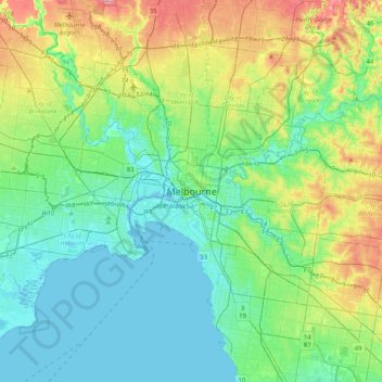
Name: Melbourne topographic map, elevation, terrain.

Location: Melbourne, City of Melbourne, Victoria, Australia (-37.97425 144.80317 -37.65425 145.12317)

Average elevation: 49 m

Minimum elevation: -5 m

Maximum elevation: 191 m

Victoria trails, hiking, mountain biking, running and outdoor activities

Other topographic maps

Click on a map to view its topography, its elevation and its terrain.

Melbourne

Australia > Victoria

Melbourne is also prone to isolated convective showers forming when a cold pool crosses the state, especially if there is considerable daytime heating. These showers are often heavy and can include hail, squalls, and significant drops in temperature, but they often pass through very quickly with a rapid…

Average elevation: 185 m

City of Melbourne

Australia > Victoria

Melbourne's topography is characterized by a diverse landscape that transitions from flat coastal plains to rolling hills and mountainous regions. The city is situated at the northern end of Port Phillip Bay, where the terrain is predominantly flat, facilitating urban development. As one moves eastward, the…

Average elevation: 18 m

Melbourne

Australia > Victoria

Melbourne is also prone to isolated convective showers forming when a cold pool crosses the state, especially if there is considerable daytime heating. These showers are often heavy and can include hail, squalls, and significant drops in temperature, but they often pass through very quickly with a rapid…

Average elevation: 185 m

Buxton

Australia > Victoria > Buxton

Average elevation: 450 m

Coburg

Australia > Victoria > Melbourne

Average elevation: 57 m

Ballarat East

Australia > Victoria > Ballarat

Average elevation: 477 m

Wodonga

Australia > Victoria

Average elevation: 191 m

Mount Eliza

Australia > Victoria > Melbourne

Average elevation: 60 m

Great Otway National Park

Australia > Victoria

Average elevation: 91 m

Eaglehawk

Australia > Victoria

Average elevation: 215 m

Shepparton District

Australia > Victoria > Shepparton

Average elevation: 113 m

Bright

Australia > Victoria

Average elevation: 550 m

Melbourne District

Australia > Victoria > Melbourne

Average elevation: 20 m

Phillip Island

Australia > Victoria > Ventnor

Average elevation: 5 m

Deans Marsh

Australia > Victoria

Average elevation: 210 m

Cudgewa

Australia > Victoria

Average elevation: 508 m

Mount Martha

Australia > Victoria > Melbourne

Average elevation: 40 m

Drummond

Australia > Victoria

Average elevation: 508 m

Falls Creek

Australia > Victoria > Falls Creek Alpine Resort

The Falls Creek Alpine Resort is an alpine ski resort in the Hume region in northeastern Victoria, Australia. It is located in the Alpine National Park in the Victorian Alps, approximately 350 kilometres (220 miles) by road from Melbourne, with the nearest town Mount Beauty, approximately 30 km (20 mi) away.…

Average elevation: 1,459 m

Buffalo River

Australia > Victoria

Formed by the east and west branches of the river, the headwaters of the Buffalo River rise in the Barry Mountains below Mount Selwyn and The Razor at an elevation exceeding 1,300 metres (4,300 ft) above sea level. The east and west branches of the river reach their confluence within the Mount Buffalo National…

Average elevation: 548 m

Reedy Creek

Australia > Victoria

Reedy Creek is a locality in central Victoria, Australia. The locality is in the Shire of Mitchell local government area, 99 kilometres (62 mi) north of the state capital, Melbourne. It is at 358 metres (1175 feet) elevation. It is approximately 15 minutes from Broadford, Vic, 3658.

Average elevation: 375 m

Merbein

Australia > Victoria

Average elevation: 45 m

Buffalo River

Australia > Victoria

Formed by the east and west branches of the river, the headwaters of the Buffalo River rise in the Barry Mountains below Mount Selwyn and The Razor at an elevation exceeding 1,300 metres (4,300 ft) above sea level. The east and west branches of the river reach their confluence within the Mount Buffalo National…

Average elevation: 548 m

Werribee

Australia > Victoria > Melbourne

Average elevation: 22 m

Macclesfield

Australia > Victoria > Melbourne

Average elevation: 181 m

Eltham District

Australia > Victoria > Greensborough

Average elevation: 85 m

Fernbank

Australia > Victoria

Average elevation: 76 m

Warrnambool

Australia > Victoria

Average elevation: 19 m

Wildwood

Australia > Victoria > Melbourne

Average elevation: 221 m

St Andrews

Australia > Victoria > Melbourne

Average elevation: 211 m

Brandy Creek

Australia > Victoria

Average elevation: 167 m

Mount Macedon

Australia > Victoria

Due to its relatively high elevation of approximately 620 metres (2,030 ft) AHD, the area experiences much cooler temperatures on average relative to nearby Melbourne. The area also receives high rainfall relative to the surrounding plains and much of the Melbourne area. This combination of geographic factors…

Average elevation: 673 m

Cobaw

Australia > Victoria

Average elevation: 558 m

Rural City of Ararat

Australia > Victoria

Average elevation: 297 m

Pakenham Upper

Australia > Victoria > Melbourne

Average elevation: 165 m

Mornington District

Australia > Victoria > Melbourne

Average elevation: 50 m

Moe

Australia > Victoria

Average elevation: 79 m

Drysdale

Australia > Victoria

Average elevation: 62 m

Port Welshpool

Australia > Victoria

Average elevation: 4 m

Footscray

Australia > Victoria > Melbourne

Average elevation: 19 m

Sunbury

Australia > Victoria > Melbourne

Average elevation: 275 m

Dandenong Ranges National Park - Ferntree Gully

Australia > Victoria > Montrose

The topography consists of a series of ridges dissected by deeply cut streams. Sheltered gullies in the south of the range are home to temperate rain forest, fern gullies and Mountain Ash forest Eucalyptus regnans, whereas the drier ridges and exposed northern slopes are covered by dry sclerophyll forest of…

Average elevation: 345 m

Nicholson

Australia > Victoria

Average elevation: 35 m

Pakenham

Australia > Victoria > Melbourne

Average elevation: 56 m

Heidelberg

Australia > Victoria > Melbourne

Average elevation: 49 m

Glen Waverley

Australia > Victoria

Average elevation: 103 m

Marysville

Australia > Victoria

Average elevation: 816 m

Rye

Australia > Victoria > Melbourne

Average elevation: 11 m

Castlemaine

Australia > Victoria

The Castlemaine goldfields' legendary prosperity raised expectations of Castlemaine becoming Victoria's second city. That is reflected in imposing buildings erected in the town's first few years. Though the rich alluvial diggings were largely exhausted within 15–20 years causing the town's population to…

Average elevation: 319 m

Port Phillip

Australia > Victoria

Port Phillip's mostly flat topography and moderate waves make perfect conditions for recreational swimming, kitesurfing, windsurfing, sailing, boating, snorkeling, scuba diving, stand up paddle boarding (SUP) and other sports.

Average elevation: 18 m

Point Cook

Australia > Victoria > Melbourne

Average elevation: 8 m

Elwood

Australia > Victoria > Melbourne

Average elevation: 8 m

Grampians National Park

Australia > Victoria

Mount William is known within the gliding community for the "Grampians Wave", a weather phenomenon that sometimes enables glider pilots to reach extreme altitudes of the order of 28,000 ft (8,500 m). This predominantly occurs during the months of May, June, September and October when strong westerly winds flow…

Average elevation: 262 m

Portarlington

Australia > Victoria

Average elevation: 38 m

Mount Waverley District

Australia > Victoria

Average elevation: 100 m

Chewton Bushlands

Australia > Victoria

Average elevation: 413 m

Betley

Australia > Victoria

Average elevation: 176 m

Anglesea

Australia > Victoria

Average elevation: 60 m

Cape Schanck

Australia > Victoria > Melbourne

Average elevation: 65 m

Albert Park

Australia > Victoria > Melbourne

Heritage Victoria notes that Albert Park's St Vincent Gardens "is historically important as the premier 'square' development in Victoria based on similar models in London. It is significant as the largest development of its type in Victoria and for its unusual development as gardens rather than the more usual…

Average elevation: 6 m

Eddington

Australia > Victoria

Average elevation: 179 m

Taylors Lakes

Australia > Victoria > Melbourne

Average elevation: 101 m

Echuca

Australia > Victoria

Average elevation: 100 m

Gippsland

Australia > Victoria

Average elevation: 273 m

Bet Bet

Australia > Victoria

Average elevation: 189 m

Herston Drive Basin

Australia > Victoria > Mildura

Average elevation: 51 m

Frankston

Australia > Victoria > Melbourne

Olivers Hill is the most prominent elevation in Frankston which rises to 55 metres above sea level (180 feet) at its highest point in the suburb. Its origins date to approximately 415 to 360 million years ago. Its base is Mount Eliza Granite dating from the Devonian period, which was covered in lava tuffs in…

Average elevation: 40 m

Irymple

Australia > Victoria

Average elevation: 50 m

Northcote District

Australia > Victoria > Melbourne

Average elevation: 44 m

Loch Sport

Australia > Victoria

Average elevation: 6 m

Springvale South

Australia > Victoria > Melbourne

Average elevation: 35 m

Wangaratta

Australia > Victoria

Average elevation: 148 m

Elwood Canal

Australia > Victoria > Melbourne

Average elevation: 6 m

Lindenow

Australia > Victoria

Average elevation: 36 m

Reedy Creek

Australia > Victoria

Reedy Creek is a locality in central Victoria, Australia. The locality is in the Shire of Mitchell local government area, 99 kilometres (62 mi) north of the state capital, Melbourne. It is at 358 metres (1175 feet) elevation. It is approximately 15 minutes from Broadford, Vic, 3658.

Average elevation: 375 m

Tooborac

Australia > Victoria

Average elevation: 337 m

Torquay

Australia > Victoria

Average elevation: 32 m

Torrumbarry

Australia > Victoria

Average elevation: 91 m

Tooradin

Australia > Victoria > Melbourne

Average elevation: 4 m

Emerald

Australia > Victoria > Melbourne

Average elevation: 225 m

Yarra Bend Park

Australia > Victoria > Melbourne

Average elevation: 31 m

Shire of Buloke

Australia > Victoria

Average elevation: 98 m

Alfredton

Australia > Victoria

Average elevation: 450 m

Strathmerton

Australia > Victoria

Average elevation: 108 m

Mud Island

Australia > Victoria

Average elevation: 0 m

Bass Coast Shire

Australia > Victoria

Average elevation: 45 m

City of Whitehorse

Australia > Victoria

Average elevation: 102 m

Shire of Mount Alexander

Australia > Victoria

Average elevation: 360 m

Caroline Springs

Australia > Victoria > Melbourne

Average elevation: 92 m

Narre Warren North

Australia > Victoria > Melbourne

Average elevation: 87 m

Coongulla

Australia > Victoria

Average elevation: 158 m

Kewell

Australia > Victoria

Average elevation: 131 m

Corindhap

Australia > Victoria

Average elevation: 254 m

Fisherman's Beach

Australia > Victoria > Melbourne

Average elevation: 13 m

Eumeralla

Australia > Victoria

Average elevation: 6 m