
Quebec topographic map
Interactive map
Click on the map to display elevation.
About this map
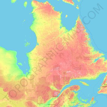
Name: Quebec topographic map, elevation, terrain.
Location: Quebec, Canada (44.99137 -79.76287 62.58250 -57.10749)
Average elevation: 195 m
Minimum elevation: -2 m
Maximum elevation: 1,383 m
Quebec's topography is very different from one region to another due to the varying composition of the ground, the climate, and the proximity to water. More than 95% of Quebec's territory, including the Labrador Peninsula, lies within the Canadian Shield. It is generally a quite flat and exposed mountainous terrain interspersed with higher points such as the Laurentian Mountains in southern Quebec, the Otish Mountains in central Quebec and the Torngat Mountains near Ungava Bay. While low and medium altitude peaks extend from western Quebec to the far north, high altitudes mountains emerge in the Capitale-Nationale region to the extreme east. Quebec's highest point at 1,652 metres (5,420 ft) is Mont d'Iberville, known in English as Mount Caubvick. In the Labrador Peninsula portion of the Shield, the far northern region of Nunavik includes the Ungava Peninsula and consists of flat Arctic tundra inhabited mostly by the Inuit. Further south is the Eastern Canadian Shield taiga ecoregion and the Central Canadian Shield forests. The Appalachian region has a narrow strip of ancient mountains along the southeastern border of Quebec.
Other topographic maps
Click on a map to view its topography, its elevation and its terrain.
High River
Canada > Alberta > Town of High River
High River, Town of High River, Alberta, T1V 1R6, Canada
Average elevation: 1,042 m
L'Ange-Gardien
Canada > Quebec > Les Collines-de-l'Outaouais
L'Ange-Gardien, Les Collines-de-l'Outaouais, Outaouais, Quebec, Canada
Average elevation: 169 m
Sandy Point
Canada > Nova Scotia > Shelburne County
Sandy Point, Municipality of the District of Shelburne, Shelburne County, Nova Scotia, B0T 1W0, Canada
Average elevation: 23 m
Sherwood Park
Canada > Alberta > Division No. 11
Sherwood Park, Division No. 11, Alberta, Canada
Average elevation: 691 m
Rivière-Bleue
Canada > Quebec > Témiscouata
Rivière-Bleue, Témiscouata, Bas-Saint-Laurent, Quebec, Canada
Average elevation: 319 m
Springton
Canada > Prince Edward Island > Queens County
Springton, Queens County, Prince Edward Island, Canada
Average elevation: 104 m
Goulbourne
Canada > Manitoba > Division No. 18 > Municipality of West Interlake
Goulbourne, Municipality of West Interlake, Division No. 18, Manitoba, Canada
Average elevation: 251 m
Delta
Canada > British Columbia > Metro Vancouver Regional District
Delta, Metro Vancouver Regional District, British Columbia, Canada
Average elevation: 13 m
Stanley Park
Canada > British Columbia > Metro Vancouver Regional District > Vancouver
Stanley Park, West End, Vancouver, Metro Vancouver Regional District, British Columbia, V6G, Canada
Average elevation: 14 m
Lake Ainslie
Canada > Nova Scotia > Municipality of the County of Inverness > MacCormicks Corner
Lake Ainslie, MacCormicks Corner, Municipality of the County of Inverness, Inverness County, Nova Scotia, Canada
Average elevation: 130 m
Bears Back Shoal
Canada > Ontario > Manitoulin District > Northeastern Manitoulin and the Islands
Bears Back Shoal, Northeastern Manitoulin and the Islands, Manitoulin District, Northeastern Ontario, Ontario, Canada
Average elevation: 176 m
Dalhousie Road
Canada > Nova Scotia > Municipality of the County of Kings
Dalhousie Road, East Dalhousie, Municipality of the County of Kings, Kings County, Nova Scotia, B0R 1H0, Canada
Average elevation: 207 m
Glen Williams
Canada > Ontario > Halton Region
Glen Williams, Halton Hills, Halton Region, Golden Horseshoe, Ontario, L7G 3S8, Canada
Average elevation: 262 m
Barons
Canada > Alberta > Division No. 2
Barons, Division No. 2, Alberta, Canada
Average elevation: 965 m
Middleville
Canada > Ontario > Lanark County > Lanark Highlands
Middleville, Lanark Highlands, Lanark County, Eastern Ontario, Ontario, Canada
Average elevation: 183 m
Alliston
Canada > Prince Edward Island > Kings County
Alliston, Kings County, Prince Edward Island, Canada
Average elevation: 60 m
Alliston
Canada > Ontario > Simcoe County
Alliston, New Tecumseth, Simcoe County, Central Ontario, Ontario, L9R 1A0, Canada
Average elevation: 233 m
MacArther Island
Canada > British Columbia > Regional District of Fraser-Fort George > Area G (Crooked River/Parsnip)
MacArther Island, Area G (Crooked River/Parsnip), Regional District of Fraser-Fort George, British Columbia, Canada
Average elevation: 713 m
Mount Barrington
Canada > British Columbia > Regional District of Kitimat-Stikine > Area D (Iskut/Big Raven)
Mount Barrington, Area D (Iskut/Big Raven), Regional District of Kitimat-Stikine, British Columbia, Canada
Average elevation: 1,437 m
Newcastle
Canada > Ontario > Durham Region > Clarington
Newcastle, Clarington, Durham Region, Golden Horseshoe, Ontario, L1B 1L2, Canada
Average elevation: 109 m
Port Nelson
Canada > Manitoba > Division No. 23 > Unorganized Division No. 23
Port Nelson, Unorganized Division No. 23, Division No. 23, Manitoba, Canada
Average elevation: 9 m
Drummond
Canada > New Brunswick > Drummond Parish
Drummond, Drummond Parish, Victoria County, New Brunswick, E3Y 2P6, Canada
Average elevation: 210 m
Parc régional du Poisson-Blanc
Canada > Quebec > Antoine-Labelle > Notre-Dame-du-Laus
Parc régional du Poisson-Blanc, Notre-Dame-du-Laus, Antoine-Labelle, Laurentides, Quebec, Canada
Average elevation: 238 m
Mount Baldy
Canada > British Columbia > qathet Regional District > Area A (Malaspina/Toba)
Mount Baldy, Area A (Malaspina/Toba), qathet Regional District, British Columbia, Canada
Average elevation: 1,246 m
Blackville
Canada > New Brunswick > Blackville Parish
Blackville, Blackville Parish, Northumberland County, New Brunswick, Canada
Average elevation: 52 m
Carleton Place
Canada > Ontario > Lanark County
Carleton Place, Lanark County, Eastern Ontario, Ontario, Canada
Average elevation: 137 m
Eastport
Canada > Newfoundland and Labrador
Eastport, Newfoundland, Newfoundland and Labrador, A0G 1Z0, Canada
Average elevation: 22 m
Canton Island
Canada > Newfoundland and Labrador
Canton Island, Labrador, Newfoundland and Labrador, Canada
Average elevation: 4 m
Swan Islands
Canada > Newfoundland and Labrador
Swan Islands, Newfoundland, Newfoundland and Labrador, Canada
Average elevation: 22 m
Mount Allen
Canada > British Columbia > Regional District of East Kootenay > Area G (Forster Creek/Mount Assiniboine)
Mount Allen, Area G (Forster Creek/Mount Assiniboine), Regional District of East Kootenay, British Columbia, Canada
Average elevation: 2,673 m
Elmsdale
Canada > Nova Scotia > Hants County
Elmsdale, East Hants District Municipality, Hants County, Nova Scotia, Canada
Average elevation: 24 m
Ferme-Neuve
Canada > Quebec > Antoine-Labelle
Ferme-Neuve, Antoine-Labelle, Laurentides, Quebec, Canada
Average elevation: 306 m
Goulburn Islands
Goulburn Islands, Kitikmeot Region, Nunavut, Canada
Average elevation: 20 m
Kingston
Canada > Nova Scotia > Municipality of the County of Kings
Kingston, Municipality of the County of Kings, Kings County, Nova Scotia, B0P 1R0, Canada
Average elevation: 30 m
Frenchman's Head
Canada > Newfoundland and Labrador > Frenchman's Cove
Frenchman's Head, Frenchman's Cove, Newfoundland, Newfoundland and Labrador, A0E 1T0, Canada
Average elevation: 0 m
Mont-Saint-Hilaire
Canada > Quebec > La Vallée-du-Richelieu
Mont-Saint-Hilaire, La Vallée-du-Richelieu, Montérégie, Quebec, Canada
Average elevation: 41 m
Bigger Lake
Canada > Ontario > Rainy River District > Atikokan
Bigger Lake, Atikokan, Rainy River District, Northwestern Ontario, Ontario, Canada
Average elevation: 410 m
Come By Chance
Canada > Newfoundland and Labrador
Come By Chance, Newfoundland, Newfoundland and Labrador, Canada
Average elevation: 58 m
King Island
Canada > British Columbia > Central Coast Regional District
King Island, Central Coast Regional District, British Columbia, Canada
Average elevation: 330 m
Greenfield
Canada > Nova Scotia > Queens County
Greenfield, Region of Queens Municipality, Queens County, Nova Scotia, B0T 1E0, Canada
Average elevation: 85 m
Blacksmith
Canada > Newfoundland and Labrador > Fermeuse
Blacksmith, Fermeuse, Newfoundland, Newfoundland and Labrador, Canada
Average elevation: 39 m
Champlain
Canada > Quebec > Les Chenaux
Champlain, Les Chenaux, Mauricie, Quebec, G0X 1C0, Canada
Average elevation: 17 m