
Bavaria topographic map
Interactive map
Click on the map to display elevation.
About this map
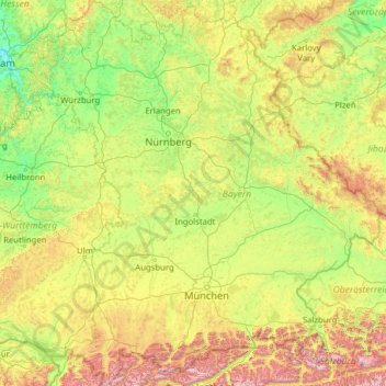
Name: Bavaria topographic map, elevation, terrain.
Location: Bavaria, Germany (47.27011 8.97637 50.56471 13.83965)
Average elevation: 566 m
Minimum elevation: 104 m
Maximum elevation: 2,850 m
Other topographic maps
Click on a map to view its topography, its elevation and its terrain.
Hamm
Germany > North Rhine – Westphalia
Hamm, North Rhine – Westphalia, Germany
Average elevation: 75 m
Mitwitz
Germany > Bavaria > Landkreis Kronach
Mitwitz, Mitwitz (VGem), Landkreis Kronach, Bavaria, 96268, Germany
Average elevation: 353 m
Ebert
Germany > Saarland > Landkreis Saarlouis > Lebach
Ebert, Lebach, Landkreis Saarlouis, Saarland, 66822, Germany
Average elevation: 361 m
Volkspark
Germany > Rhineland-Palatinate > Mainz
Volkspark, Oberstadt, Mainz, Rhineland-Palatinate, 55131, Germany
Average elevation: 106 m
Wambach
Germany > Hesse > Rheingau-Taunus-Kreis > Schlangenbad
Wambach, Schlangenbad, Rheingau-Taunus-Kreis, Hesse, Germany
Average elevation: 425 m
Arpe
Germany > North Rhine-Westphalia > Hochsauerlandkreis > Schmallenberg
Arpe, Schmallenberg, Hochsauerlandkreis, North Rhine-Westphalia, Germany
Average elevation: 422 m
Lückenrieth
Germany > Bavaria > Landkreis Neustadt an der Waldnaab
Lückenrieth, Leuchtenberg, Tännesberg (VGem), Landkreis Neustadt an der Waldnaab, Bavaria, 92705, Germany
Average elevation: 489 m
Wendelstein
Wendelstein, Roth, Bavaria, 90530, Germany
Average elevation: 355 m
Vaihingen an der Enz
Germany > Baden-Württemberg > Landkreis Ludwigsburg
Vaihingen an der Enz, VVG Vaihingen an der Enz, Landkreis Ludwigsburg, Baden-Württemberg, Germany
Average elevation: 283 m
Ruhr area
Germany > North Rhine-Westphalia
Ruhr area, North Rhine-Westphalia, Germany
Average elevation: 117 m
Am See
Germany > Bavaria > Landkreis Miesbach > Sankt Quirin
Am See, Sankt Quirin, Gmund, Landkreis Miesbach, Bavaria, 83703, Germany
Average elevation: 797 m
Welcherath
Germany > Rhineland-Palatinate > Landkreis Vulkaneifel
Welcherath, Kelberg, Landkreis Vulkaneifel, Rhineland-Palatinate, Germany
Average elevation: 534 m
Kreis Wesel
Germany > North Rhine-Westphalia
Kreis Wesel, North Rhine-Westphalia, Germany
Average elevation: 34 m
Witzenhausen
Germany > Hesse > Werra-Meißner-Kreis
Witzenhausen, Werra-Meißner-Kreis, Hesse, Germany
Average elevation: 297 m
Friedrichshain-Kreuzberg
Friedrichshain-Kreuzberg, Berlin, Germany
Average elevation: 45 m
Reichenau
Germany > Baden-Württemberg > Landkreis Konstanz > Reichenau
Reichenau, Verwaltungsgemeinschaft Konstanz, Landkreis Konstanz, Baden-Württemberg, 78479, Germany
Average elevation: 397 m
Grove
Germany > Schleswig-Holstein > Herzogtum Lauenburg
Grove, Schwarzenbek-Land, Herzogtum Lauenburg, Schleswig-Holstein, Germany
Average elevation: 43 m
Saterland - Seelterlound
Germany > Lower Saxony > Cloppenburg district
Saterland - Seelterlound, Cloppenburg district, Lower Saxony, 26683, Germany
Average elevation: 5 m
Böblingen
Germany > Baden-Württemberg > Landkreis Böblingen
Böblingen, Landkreis Böblingen, Baden-Württemberg, Germany
Average elevation: 466 m
Hanover
Germany > Lower Saxony > Region Hannover
Hanover, Region Hannover, Lower Saxony, Germany
Average elevation: 61 m
Sasbachwalden
Germany > Baden-Württemberg > Ortenaukreis
Sasbachwalden, Verwaltungsgemeinschaft Achern, Ortenaukreis, Baden-Württemberg, 77887, Germany
Average elevation: 382 m
Chorin
Germany > Brandenburg > Barnim
Chorin, Britz-Chorin-Oderberg, Barnim, Brandenburg, Germany
Average elevation: 55 m
Löbau
Germany > Saxony > Görlitz - Zhorjelc
Löbau, Görlitz - Zhorjelc, Saxony, 02708, Germany
Average elevation: 273 m
Teterow
Germany > Mecklenburg-Vorpommern > Landkreis Rostock
Teterow, Landkreis Rostock, Mecklenburg-Vorpommern, 17166, Germany
Average elevation: 39 m
Neu-Ulm
Germany > Bavaria > Landkreis Neu-Ulm
Neu-Ulm, Landkreis Neu-Ulm, Bavaria, Germany
Average elevation: 498 m
Espenberg
Germany > Thuringia > Landkreis Nordhausen > Hohenstein
Espenberg, Hohenstein, Landkreis Nordhausen, Thuringia, 99755, Germany
Average elevation: 247 m
Lichtenstein
Germany > Baden-Württemberg > Landkreis Reutlingen
Lichtenstein, Hohenstein, Landkreis Reutlingen, Baden-Württemberg, 72805, Germany
Average elevation: 689 m
Wind
Germany > Bavaria > Landkreis Bamberg
Wind, Pommersfelden, Landkreis Bamberg, Bavaria, 96178, Germany
Average elevation: 284 m
Wallen
Germany > Schleswig-Holstein > Dithmarschen
Wallen, Eider, Dithmarschen, Schleswig-Holstein, Germany
Average elevation: 1 m
Templin
Germany > Brandenburg > Uckermark
Templin, Uckermark, Brandenburg, 17268, Germany
Average elevation: 64 m
Bremerhaven
Germany > Free Hanseatic City of Bremen
Bremerhaven, Free Hanseatic City of Bremen, Germany
Average elevation: 2 m
Tannenberg
Germany > Saxony > Erzgebirgskreis
Tannenberg, Verwaltungsgemeinschaft Geyer, Erzgebirgskreis, Saxony, Germany
Average elevation: 590 m
Carum
Germany > Lower Saxony > Landkreis Vechta
Carum, Bakum, Landkreis Vechta, Lower Saxony, 49413, Germany
Average elevation: 28 m
Kirchhorsten
Germany > Lower Saxony > Landkreis Schaumburg > Helpsen
Kirchhorsten, Helpsen, Samtgemeinde Nienstädt, Landkreis Schaumburg, Lower Saxony, 31691, Germany
Average elevation: 74 m
Wehrheim
Germany > Hesse > Hochtaunuskreis
Wehrheim, Hochtaunuskreis, Hesse, 61273, Germany
Average elevation: 346 m
Quelitz
Germany > Thuringia > Landkreis Saalfeld-Rudolstadt > Unterweißbach
Quelitz, Unterweißbach, Schwarzatal, Landkreis Saalfeld-Rudolstadt, Thuringia, 07429, Germany
Average elevation: 509 m
Steinach
Germany > Baden-Württemberg > Ortenaukreis
Steinach, Verwaltungsgemeinschaft Haslach im Kinzigtal, Ortenaukreis, Baden-Württemberg, 77790, Germany
Average elevation: 370 m
Osterode am Harz
Germany > Lower Saxony > Landkreis Göttingen
Osterode am Harz, Landkreis Göttingen, Lower Saxony, 37520, Germany
Average elevation: 304 m
Eckdorf
Germany > North Rhine-Westphalia > Rhein-Erft-Kreis > Brühl
Eckdorf, Brühl, Rhein-Erft-Kreis, North Rhine-Westphalia, 50321, Germany
Average elevation: 106 m
Steinendorf
Germany > North Rhine-Westphalia > Solingen
Steinendorf, Ohligs/Aufderhöhe/Merscheid, Solingen, North Rhine-Westphalia, 42699, Germany
Average elevation: 121 m