Geolocate

Chipping Barnet topographic map

Interactive map

Click on the map to display elevation.

Chipping Barnet

Its name is very often abbreviated to just Barnet, which is also the name of the borough of which it forms a part; the town has been part of Greater London since 1965 after the abolition of Barnet Urban District then in Hertfordshire. Chipping Barnet is also the name of the Parliamentary constituency covering the local area – the word "Chipping" denotes the presence of a market, one that was established here at the end of the 12th century and persists to this day. Chipping Barnet is one of the highest urban settlements in London, with the town centre having an elevation of about 427 feet (130 m).

Wikipedia (CC-BY-SA 3.0)

About this map

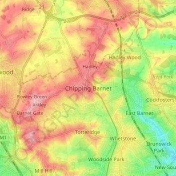
Name: Chipping Barnet topographic map, elevation, terrain.

Location: Chipping Barnet, Greater London, England, EN5 5SB, United Kingdom (51.61309 -0.24023 51.69309 -0.16023)

Average elevation: 95 m

Minimum elevation: 36 m

Maximum elevation: 147 m

Other topographic maps

Click on a map to view its topography, its elevation and its terrain.

Bristol

United Kingdom > England > City of Bristol

Average elevation: 55 m

Nottingham

United Kingdom > England > Nottinghamshire

Average elevation: 56 m

Birmingham

United Kingdom > England

Birmingham is a snowy city relative to other large UK conurbations, due to its inland location and comparatively high elevation. Between 1961 and 1990 Birmingham Airport averaged 13.0 days of snow lying annually, compared to 5.33 at London Heathrow. Snow showers often pass through the city via the Cheshire gap…

Average elevation: 138 m

South East England

United Kingdom > England

Near Weybridge are the UK headquarters of Sony with SSP Group (situated in Byfleet) and Procter & Gamble (next door to each other on The Heights Business Park near the former Brooklands racing circuit) with Kia Motors UK and Petroleum Geo-Services UK, and Gallaher Group (cigarettes) is to the north, next to…

Average elevation: 69 m

Exeter

United Kingdom > England > Devon

The city of Exeter was established on the eastern bank of the River Exe on a ridge of land backed by a steep hill. It is at this point that the Exe, having just been joined by the River Creedy, opens onto a wide flood plain and estuary which results in quite common flooding. Historically this was the lowest…

Average elevation: 56 m

Sheffield

United Kingdom > England

Average elevation: 168 m

Norfolk

United Kingdom > England

Average elevation: 23 m

Isle of Wight

United Kingdom > England

Average elevation: 17 m

Barnsley

United Kingdom > England

Average elevation: 139 m

London

United Kingdom > England

London's topography is characterized by a gently rolling terrain shaped by the River Thames and its tributaries. The city lies within the London Basin, a natural depression bordered by higher grounds such as the North Downs to the south and the Chiltern Hills to the northwest. The Thames flows west to east,…

Average elevation: 66 m

Bath

United Kingdom > England > Bath and North East Somerset

Bath is in the Avon Valley and is surrounded by limestone hills as it is near the southern edge of the Cotswolds, a designated Area of Outstanding Natural Beauty, and the limestone Mendip Hills rise around 7 miles (11 km) south of the city. The hills that surround and make up the city have a maximum altitude…

Average elevation: 100 m

Brighton

United Kingdom > England > Brighton and Hove

Average elevation: 64 m

River Thames

United Kingdom > England

Average elevation: 84 m

Sussex

United Kingdom > England

Average elevation: 39 m

East Midlands

United Kingdom > England

The highest point at 636 m (2,087 ft) is Kinder Scout, in the Peak District of the southern Pennines in northwest Derbyshire near Glossop. Other hilly areas of 95 to 280 m (312 to 919 ft) in altitude, together with lakes and reservoirs, rise in and around the Charnwood Forest north of Peterborough, Leicester,…

Average elevation: 75 m

Dover

United Kingdom > England > Kent

Average elevation: 39 m

Chichester

United Kingdom > England > West Sussex

Average elevation: 57 m

Hastings

United Kingdom > England > East Sussex

Average elevation: 36 m

Brentwood

United Kingdom > England > Essex

Average elevation: 64 m

Lake District National Park

United Kingdom > England

The Lake District is a roughly circular upland massif, deeply dissected by a broadly radial pattern of major valleys which are largely the result of repeated glaciations over the last 2 million years. The apparent radial pattern is not from a central dome, but from an axial watershed extending from St Bees…

Average elevation: 206 m

Stockport

United Kingdom > England

Average elevation: 95 m

Dartmoor National Park

United Kingdom > England > Devon

Rainfall tends to be associated with Atlantic depressions or with convection. In summer, convection caused by solar surface heating sometimes forms shower clouds and a large proportion of rainfall falls from showers and thunderstorms at this time of year. The wettest months are November and December and on the…

Average elevation: 239 m

Dorset

United Kingdom > England > Talbot Village

Average elevation: 57 m

Oxford

United Kingdom > England > Oxfordshire

Average elevation: 81 m

Norwich

United Kingdom > England > Norfolk

Average elevation: 28 m

Branxton

United Kingdom > England > Northumberland

Average elevation: 101 m

East of England

United Kingdom > England

The East of England region has the lowest elevation range in the UK. Twenty percent of the region is below mean sea level, most of this in North Cambridgeshire, Norfolk and on the Essex Coast. Most of the remaining area is of low elevation, with extensive glacial deposits. The Fens, a large area of reclaimed…

Average elevation: 39 m

Lincolnshire

United Kingdom > England

Average elevation: 28 m

North Yorkshire

United Kingdom > England

Average elevation: 153 m

Stroud

United Kingdom > England > Gloucestershire

Average elevation: 113 m

Eastbourne

United Kingdom > England > East Sussex

Average elevation: 36 m

Liverpool

United Kingdom > England

Average elevation: 26 m

Somerset

United Kingdom > England

Many settlements developed because of their strategic importance in relation to geographical features, such as river crossings or valleys in ranges of hills. Examples include Axbridge on the River Axe, Castle Cary on the River Cary, North Petherton on the River Parrett, and Ilminster, where there was a…

Average elevation: 96 m

Whitbourne

United Kingdom > England > Herefordshire

Average elevation: 77 m

Todmorden

United Kingdom > England > Calderdale

Todmorden Town Hall, which was designed in the Neo-Classical style, dominates the centre of the town. The building straddles the Walsden Water, a tributary of the River Calder, and was situated in both Lancashire and Yorkshire until the administrative county boundary was moved on 1 January 1888. Designed by…

Average elevation: 311 m

West Yorkshire

United Kingdom > England

Wakefield's Parish Church was raised to cathedral status in 1888 and after the elevation of Wakefield to diocese, Wakefield Council immediately sought city status and this was granted in July 1888. However the industrial revolution, which changed West and South Yorkshire significantly, led to the growth of…

Average elevation: 172 m

Kent

United Kingdom > England

Kent was also the location of the largest number of art schools in the country during the nineteenth century, estimated by the art historian David Haste, to approach two hundred. This is believed to be the result of Kent being a front line county during the Napoleonic Wars. At this time, before the invention…

Average elevation: 37 m

Cambridgeshire

United Kingdom > England

Cambridgeshire has a maritime temperate climate which is broadly similar to the rest of the United Kingdom, though it is drier than the UK average due to its low altitude and easterly location, the prevailing southwesterly winds having already deposited moisture on higher ground further west. Average winter…

Average elevation: 32 m

Greater Manchester

United Kingdom > England

Average elevation: 141 m

Herefordshire

United Kingdom > England

Average elevation: 159 m

Surrey

United Kingdom > England > Surrey

The highest elevation in Surrey is Leith Hill near Dorking. It is 295 m (968 ft) above sea level and is the second highest point in southeastern England after Walbury Hill in West Berkshire which is 297 m (974 ft).

Average elevation: 69 m

Somerset

United Kingdom > England

Average elevation: 87 m

Cheltenham

United Kingdom > England > Gloucestershire

Average elevation: 109 m

Northampton

United Kingdom > England > West Northamptonshire > Northampton

As with the rest of the British Isles, Northampton experiences a maritime climate with cool summers and mild winters. The official Met Office weather station for Northampton is the Moulton Park Weather Station at the University of Northampton. Situated at an elevation of around 130 m (427 ft) above sea level…

Average elevation: 89 m

Oxford

United Kingdom > England > Oxfordshire

Average elevation: 81 m

Canterbury

United Kingdom > England > Kent

Average elevation: 51 m

Lancaster

United Kingdom > England > Lancashire

Average elevation: 84 m

Southampton

United Kingdom > England

Average elevation: 22 m

Guildford

United Kingdom > England > Surrey

Average elevation: 74 m

Willisham

United Kingdom > England > Suffolk

Average elevation: 61 m

Kent

United Kingdom > England

Kent was also the location of the largest number of art schools in the country during the nineteenth century, estimated by the art historian David Haste, to approach two hundred. This is believed to be the result of Kent being a front line county during the Napoleonic Wars. At this time, before the invention…

Average elevation: 37 m

Cambridge

United Kingdom > England > Cambridgeshire

The city, like most of the UK, has a maritime climate highly influenced by the Gulf Stream. Located in the driest region of Britain, Cambridge's rainfall averages around 570 mm (22.44 in) per year, around half the national average, The driest recent year was in 2011 with 380.4 mm (14.98 in) of rain at the…

Average elevation: 18 m

Portland

United Kingdom > England > Dorset > Castletown

Average elevation: 8 m

Consett

United Kingdom > England > County Durham

Average elevation: 205 m

Portsmouth

United Kingdom > England

Portsmouth is 73.5 miles (118.3 km) by road from central London, 49.5 miles (79.7 km) west of Brighton, and 22.3 miles (35.9 km) east of Southampton. It is located primarily on Portsea Island and is the United Kingdom's only island city, although the city has expanded to the mainland. Gosport is a borough to…

Average elevation: 7 m

Wiltshire

United Kingdom > England

Average elevation: 115 m

Gloucestershire

United Kingdom > England

Average elevation: 99 m

East Riding of Yorkshire

United Kingdom > England

The western part of the district in the Vale of York borders on and is drained by the River Derwent. The landscape is generally low-lying and flat although minor ridges and glacial moraines provide some variations in topography. Where there are dry sandy soils there are remnants of historic heathlands and…

Average elevation: 30 m

Suffolk

United Kingdom > England

The west of the county lies on more resistant Cretaceous chalk. This chalk is responsible for a sweeping tract of largely downland landscapes that stretches from Dorset in the south west to Dover in the south east and north through East Anglia to the Yorkshire Wolds. The chalk is less easily eroded so forms…

Average elevation: 35 m

Essex

United Kingdom > England

Average elevation: 44 m

Northumberland

United Kingdom > England

Average elevation: 141 m

Devon

United Kingdom > England

Average elevation: 94 m

Cornwall

United Kingdom > England

The interior of the county consists of a roughly east–west spine of infertile and exposed upland, with a series of granite intrusions, such as Bodmin Moor, which contains the highest land within Cornwall. From east to west, and with approximately descending altitude, these are Bodmin Moor, Hensbarrow north…

Average elevation: 55 m

Lancashire

United Kingdom > England

Average elevation: 153 m

Greater London

United Kingdom > England

Average elevation: 66 m

Berkshire

United Kingdom > England

All of the county is drained by the Thames. Berkshire divides into two topological (and associated geological) sections: east and west of Reading. North-east Berkshire has the low calciferous (limestone) m-shaped bends of the Thames south of which is a broader, clayey, gravelly former watery plain or belt from…

Average elevation: 100 m

Manchester

United Kingdom > England

Average elevation: 66 m

Gloucester

United Kingdom > England > Gloucestershire

Average elevation: 36 m

Dover

United Kingdom > England > Kent

Average elevation: 39 m

Winchester

United Kingdom > England > Hampshire

Average elevation: 73 m

Lewes

United Kingdom > England > East Sussex

Average elevation: 40 m

Corby

United Kingdom > England > North Northamptonshire > Corby

Average elevation: 98 m

Lincoln

United Kingdom > England > Lincolnshire

Lincoln lies 157 mi (253 km) north of London, at an altitude of 67 ft (20.4 m) by the River Witham up to 246 ft (75.0 m) on Castle Hill. It fills a gap in the Lincoln Cliff escarpment, which runs north and south through central Lincolnshire, with altitudes up to 200 feet (61 metres). The city lies on the River…

Average elevation: 29 m

Cambridge

United Kingdom > England > Cambridge

The city, like most of the UK, has a maritime climate highly influenced by the Gulf Stream. Located in the driest region of Britain, Cambridge's rainfall averages around 570 mm (22.44 in) per year, around half the national average, with some years occasionally falling into the semi-arid (under 500 mm (19.69…

Average elevation: 18 m

St Albans

United Kingdom > England > Hertfordshire > St Albans

St Albans was an ancient borough created following the dissolution of the monastery in 1539. It consisted of the ancient parish of St Albans (also known as the Abbey parish) and parts of St Michael and St Peter. The municipal corporation was reformed by the Municipal Corporations Act 1835 and the boundary was…

Average elevation: 100 m

Chelmsford

United Kingdom > England > Essex

Average elevation: 54 m

Harlow

United Kingdom > England > Essex

Average elevation: 69 m

Leeds

United Kingdom > England

Average elevation: 96 m

Coventry

United Kingdom > England

Average elevation: 99 m

Borough of Luton

United Kingdom > England

The local climate around Luton is differentiated somewhat from much of South East England due to its position in the Chiltern Hills, meaning it tends to be 1–2 degrees Celsius cooler than the surrounding towns – often flights at Luton airport, lying 160 m (525 ft) above sea level, will be suspended when…

Average elevation: 146 m

Southend-on-Sea

United Kingdom > England > Essex

Average elevation: 12 m

Hastings

United Kingdom > England > East Sussex

Average elevation: 36 m

Keswick

United Kingdom > England > Cumberland

Average elevation: 128 m

Battle

United Kingdom > England > East Sussex > Rother > Battle

Average elevation: 66 m