Geolocate

Dallas County topographic map

Click on the map to display elevation.

About this map

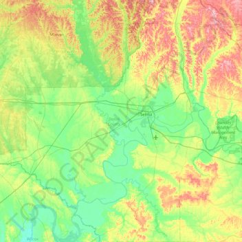
Name: Dallas County topographic map, elevation, terrain.

Location: Dallas County, Alabama, United States (32.04693 -87.47318 32.72799 -86.80706)

Average elevation: 69 m

Minimum elevation: 14 m

Maximum elevation: 193 m

Other topographic maps

Click on a map to view its topography, its elevation and its terrain.

Forestdale

United States > Alabama > Jefferson County

Average elevation: 180 m

Sandfield

United States > Alabama > Pike County

Average elevation: 156 m

Owenton

United States > Alabama > Jefferson County > Birmingham

Average elevation: 177 m

Red Bank

United States > Alabama > Lawrence County

Average elevation: 173 m

Little Bay

United States > Alabama > Mobile County

Average elevation: 1 m

Brassell

United States > Alabama > Montgomery County

Average elevation: 53 m

Pine Hill

United States > Alabama > Wilcox County

Average elevation: 42 m

Auburn

United States > Alabama > Lee County > Auburn

The southwest and west regions of the city on the plateau are marked by rolling plains and savannahs, with the undeveloped portion primarily being used for cattle grazing and ranching. South of this region sits the coastal plain, with sandy soil and pine forest. Parts of north Auburn have much more rugged…

Average elevation: 189 m

Forestdale

United States > Alabama > Lee County > Auburn > Forestdale

Average elevation: 203 m

Meadowbrook

United States > Alabama > Shelby County

Average elevation: 192 m

Wedgeworth

United States > Alabama > Hale County > Wedgeworth

Average elevation: 42 m

Repton

United States > Alabama > Conecuh County > Repton

Average elevation: 100 m

Woodville

United States > Alabama > Jackson County > Woodville

Average elevation: 212 m

Saint Ives

United States > Alabama > Talladega County

Average elevation: 157 m

Wiley

United States > Alabama > Montgomery County > Montgomery

Average elevation: 57 m

Gear up for your next adventure:

📣High-Decibel Survival Whistles - Signaling tool for rescue that carries much further than a human voice
🧰Survival Kits - Essential survival gear
📚Map Reading & Navigation Guides - Master the art of interpreting topographic contours and symbols
🎒Hiking Backpacks - Backpacks designed for hiking and trekking
🥤Hydration Packs - Hydration systems for hiking

As an Amazon Associate, this site earns from qualifying purchases at no extra cost to you.