
Prince Edward Island topographic map
Interactive map
Click on the map to display elevation.
About this map
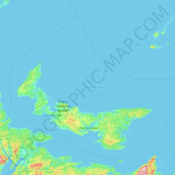
Name: Prince Edward Island topographic map, elevation, terrain.
Location: Prince Edward Island, Canada (45.84946 -64.55191 47.60248 -61.39937)
Average elevation: 8 m
Minimum elevation: -3 m
Maximum elevation: 314 m
Other topographic maps
Click on a map to view its topography, its elevation and its terrain.
The Three Sisters
Canada > Ontario > Algoma District > The North Shore Township
The Three Sisters, The North Shore Township, Algoma District, Northeastern Ontario, Ontario, Canada
Average elevation: 241 m
Little Big Horn
Canada > British Columbia > Squamish-Lillooet Regional District > Area A (Upper Bridge River Valley)
Little Big Horn, Area A (Upper Bridge River Valley), Squamish-Lillooet Regional District, British Columbia, Canada
Average elevation: 1,986 m
Ellerslie
Canada > Alberta > Division No. 11 > Edmonton
Ellerslie, Edmonton, Division No. 11, Alberta, Canada
Average elevation: 699 m
Tweed
Canada > Ontario > Hastings County
Tweed, Hastings County, Central Ontario, Ontario, Canada
Average elevation: 231 m
King's Point
Canada > Newfoundland and Labrador
King's Point, Newfoundland, Newfoundland and Labrador, A0J 1H0, Canada
Average elevation: 147 m
Quinte West (city)
Quinte West (city), Central Ontario, Ontario, K0K 1E0, Canada
Average elevation: 160 m
Victoria Square
Canada > Quebec > Urban agglomeration of Montreal > Montreal
Victoria Square, Quartier international, Ville-Marie, Montreal, Urban agglomeration of Montreal, Montreal (administrative region), Quebec, Canada
Average elevation: 32 m
Highest Point in Saskatchewan
Canada > Saskatchewan > Maple Creek No. 111
Highest Point in Saskatchewan, Maple Creek No. 111, Division No. 4, Saskatchewan, Canada
Average elevation: 1,378 m
Town of Mulgrave
Canada > Nova Scotia > Guysborough County
Town of Mulgrave, Guysborough County, Nova Scotia, B0E 2G0, Canada
Average elevation: 62 m
Grand Lake Road
Canada > Nova Scotia > Cape Breton Regional Municipality
Grand Lake Road, Cape Breton Regional Municipality, Cape Breton County, Nova Scotia, Canada
Average elevation: 47 m
Copper Cliff
Canada > Ontario > Sudbury District > Greater Sudbury
Copper Cliff, Greater Sudbury, Sudbury District, Northeastern Ontario, Ontario, P0M 1N0, Canada
Average elevation: 286 m
Blue Mountain
Canada > Nova Scotia > Municipality of the County of Kings
Blue Mountain, Municipality of the County of Kings, Kings County, Nova Scotia, B4N 3V8, Canada
Average elevation: 224 m
Garson
Canada > Ontario > Sudbury District > Greater Sudbury
Garson, Greater Sudbury, Sudbury District, Northeastern Ontario, Ontario, P3L 1T7, Canada
Average elevation: 292 m
L'Ange-Gardien
Canada > Quebec > Les Collines-de-l'Outaouais
L'Ange-Gardien, Les Collines-de-l'Outaouais, Outaouais, Quebec, Canada
Average elevation: 169 m
High River
Canada > Alberta > Town of High River
High River, Town of High River, Alberta, T1V 1R6, Canada
Average elevation: 1,042 m
Sandy Point
Canada > Nova Scotia > Shelburne County
Sandy Point, Municipality of the District of Shelburne, Shelburne County, Nova Scotia, B0T 1W0, Canada
Average elevation: 23 m
Sherwood Park
Canada > Alberta > Division No. 11
Sherwood Park, Division No. 11, Alberta, Canada
Average elevation: 691 m
Rivière-Bleue
Canada > Quebec > Témiscouata
Rivière-Bleue, Témiscouata, Bas-Saint-Laurent, Quebec, Canada
Average elevation: 319 m
Springton
Canada > Prince Edward Island > Queens County
Springton, Queens County, Prince Edward Island, Canada
Average elevation: 104 m
Goulbourne
Canada > Manitoba > Division No. 18 > Municipality of West Interlake
Goulbourne, Municipality of West Interlake, Division No. 18, Manitoba, Canada
Average elevation: 251 m
Delta
Canada > British Columbia > Metro Vancouver Regional District
Delta, Metro Vancouver Regional District, British Columbia, Canada
Average elevation: 13 m
Stanley Park
Canada > British Columbia > Metro Vancouver Regional District > Vancouver
Stanley Park, West End, Vancouver, Metro Vancouver Regional District, British Columbia, V6G, Canada
Average elevation: 14 m
Lake Ainslie
Canada > Nova Scotia > Municipality of the County of Inverness > MacCormicks Corner
Lake Ainslie, MacCormicks Corner, Municipality of the County of Inverness, Inverness County, Nova Scotia, Canada
Average elevation: 130 m
Glen Williams
Canada > Ontario > Halton Region
Glen Williams, Halton Hills, Halton Region, Golden Horseshoe, Ontario, L7G 3S8, Canada
Average elevation: 262 m
Bears Back Shoal
Canada > Ontario > Manitoulin District > Northeastern Manitoulin and the Islands
Bears Back Shoal, Northeastern Manitoulin and the Islands, Manitoulin District, Northeastern Ontario, Ontario, Canada
Average elevation: 176 m
Dalhousie Road
Canada > Nova Scotia > Municipality of the County of Kings
Dalhousie Road, East Dalhousie, Municipality of the County of Kings, Kings County, Nova Scotia, B0R 1H0, Canada
Average elevation: 207 m
Barons
Canada > Alberta > Division No. 2
Barons, Division No. 2, Alberta, Canada
Average elevation: 965 m
Middleville
Canada > Ontario > Lanark County > Lanark Highlands
Middleville, Lanark Highlands, Lanark County, Eastern Ontario, Ontario, Canada
Average elevation: 183 m
Alliston
Canada > Prince Edward Island > Kings County
Alliston, Kings County, Prince Edward Island, Canada
Average elevation: 60 m
Alliston
Canada > Ontario > Simcoe County
Alliston, New Tecumseth, Simcoe County, Central Ontario, Ontario, L9R 1A0, Canada
Average elevation: 233 m
MacArther Island
Canada > British Columbia > Regional District of Fraser-Fort George > Area G (Crooked River/Parsnip)
MacArther Island, Area G (Crooked River/Parsnip), Regional District of Fraser-Fort George, British Columbia, Canada
Average elevation: 713 m
Mount Barrington
Canada > British Columbia > Regional District of Kitimat-Stikine > Area D (Iskut/Big Raven)
Mount Barrington, Area D (Iskut/Big Raven), Regional District of Kitimat-Stikine, British Columbia, Canada
Average elevation: 1,437 m
Newcastle
Canada > Ontario > Durham Region > Clarington
Newcastle, Clarington, Durham Region, Golden Horseshoe, Ontario, L1B 1L2, Canada
Average elevation: 109 m
Port Nelson
Canada > Manitoba > Division No. 23 > Unorganized Division No. 23
Port Nelson, Unorganized Division No. 23, Division No. 23, Manitoba, Canada
Average elevation: 9 m
Drummond
Canada > New Brunswick > Drummond Parish
Drummond, Drummond Parish, Victoria County, New Brunswick, E3Y 2P6, Canada
Average elevation: 210 m
Parc régional du Poisson-Blanc
Canada > Quebec > Antoine-Labelle > Notre-Dame-du-Laus
Parc régional du Poisson-Blanc, Notre-Dame-du-Laus, Antoine-Labelle, Laurentides, Quebec, Canada
Average elevation: 238 m
Mount Baldy
Canada > British Columbia > qathet Regional District > Area A (Malaspina/Toba)
Mount Baldy, Area A (Malaspina/Toba), qathet Regional District, British Columbia, Canada
Average elevation: 1,246 m
Blackville
Canada > New Brunswick > Blackville Parish
Blackville, Blackville Parish, Northumberland County, New Brunswick, Canada
Average elevation: 52 m
Carleton Place
Canada > Ontario > Lanark County
Carleton Place, Lanark County, Eastern Ontario, Ontario, Canada
Average elevation: 137 m
Eastport
Canada > Newfoundland and Labrador
Eastport, Newfoundland, Newfoundland and Labrador, A0G 1Z0, Canada
Average elevation: 22 m
Canton Island
Canada > Newfoundland and Labrador
Canton Island, Labrador, Newfoundland and Labrador, Canada
Average elevation: 4 m
Swan Islands
Canada > Newfoundland and Labrador
Swan Islands, Newfoundland, Newfoundland and Labrador, Canada
Average elevation: 22 m
Mount Allen
Canada > British Columbia > Regional District of East Kootenay > Area G (Forster Creek/Mount Assiniboine)
Mount Allen, Area G (Forster Creek/Mount Assiniboine), Regional District of East Kootenay, British Columbia, Canada
Average elevation: 2,673 m
Elmsdale
Canada > Nova Scotia > Hants County
Elmsdale, East Hants District Municipality, Hants County, Nova Scotia, Canada
Average elevation: 24 m
Ferme-Neuve
Canada > Quebec > Antoine-Labelle
Ferme-Neuve, Antoine-Labelle, Laurentides, Quebec, Canada
Average elevation: 306 m