
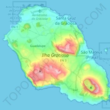
Santa Cruz da Graciosa topographic map
Interactive map
Click on the map to display elevation.
About this map
Name: Santa Cruz da Graciosa topographic map, elevation, terrain.
Location: Santa Cruz da Graciosa, Azores, Portugal (39.00861 -28.07230 39.09716 -27.94781)
Average elevation: 65 m
Minimum elevation: 0 m
Maximum elevation: 400 m
Other topographic maps
Click on a map to view its topography, its elevation and its terrain.
Tortosendo
Portugal > Castelo Branco > Covilhã
Tortosendo, Covilhã, Castelo Branco, Portugal
Average elevation: 564 m
Olgas
Portugal > Vila Real > Ribeira de Pena
Olgas, Ribeira de Pena (Salvador) e Santo Aleixo de Além-Tâmega, Ribeira de Pena, Vila Real, 4870-162, Portugal
Average elevation: 652 m
Pico do Gralheiro
Portugal > Aveiro > Vale de Cambra
Pico do Gralheiro, Vale de Cambra, Aveiro, 4540-013, Portugal
Average elevation: 879 m
Carambola
Portugal > Coimbra > Pampilhosa da Serra
Carambola, Pampilhosa da Serra, Coimbra, Portugal
Average elevation: 934 m
Vale Torto
Portugal > Coimbra > Seixo da Beira
Vale Torto, Seixo da Beira, Oliveira do Hospital, Coimbra, 6270-134, Portugal
Average elevation: 337 m
Branda de Santo António
Portugal > Viana do Castelo > Riba de Mouro
Branda de Santo António, Riba de Mouro, Monção, Viana do Castelo, Portugal
Average elevation: 977 m
Tangil
Tangil, Monção, Viana do Castelo, 4950-770, Portugal
Average elevation: 347 m
Alvoco da Serra
Alvoco da Serra, Seia, Guarda, 6270-013, Portugal
Average elevation: 995 m
Barragem do Carrapatelo
Portugal > Viseu > São Cristóvão de Nogueira > Mouril
Barragem do Carrapatelo, Mouril, São Cristóvão de Nogueira, Cinfães, Viseu, Portugal
Average elevation: 193 m
Barragem da Crestuma-Lever
Portugal > Porto > Vila Nova de Gaia > Lever
Barragem da Crestuma-Lever, Lever, Vila Nova de Gaia, Porto, Portugal
Average elevation: 72 m
São Félix da Marinha
Portugal > Porto > Vila Nova de Gaia
São Félix da Marinha, Vila Nova de Gaia, Porto, Portugal
Average elevation: 45 m
Queluz e Belas
Portugal > Lisbon > Queluz e Belas
Queluz e Belas, Sintra, Lisbon, Portugal
Average elevation: 184 m
Santa Sabina
Santa Sabina, Mesão Frio, Vila Real, 5040-154, Portugal
Average elevation: 299 m
Área Metropolitana de Lisboa
Portugal > Área Metropolitana de Lisboa
Área Metropolitana de Lisboa, Portugal
Average elevation: 59 m
Barão de São João
Portugal > Faro > Bensafrim e Barão de São João > Barão de São João
Barão de São João, Bensafrim e Barão de São João, Lagos, Faro, 8600-013, Portugal
Average elevation: 88 m
São João Baptista
Portugal > Centro > Entroncamento
São João Baptista, Entroncamento, Santarém, Centro, Portugal
Average elevation: 46 m