
Make a donation
Gear up for your next adventure:
As an Amazon Associate, this site earns from qualifying purchases at no extra cost to you.
Washington County topographic map
Click on the map to display elevation.
Make a donation
Gear up for your next adventure:
As an Amazon Associate, this site earns from qualifying purchases at no extra cost to you.
About this map
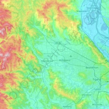
Name: Washington County topographic map, elevation, terrain.
Location: Washington County, Oregon, United States (45.31720 -123.48606 45.78016 -122.74251)
Average elevation: 213 m
Minimum elevation: -3 m
Maximum elevation: 1,063 m
Make a donation
Gear up for your next adventure:
As an Amazon Associate, this site earns from qualifying purchases at no extra cost to you.
Other topographic maps
Click on a map to view its topography, its elevation and its terrain.
Make a donation
Gear up for your next adventure:
As an Amazon Associate, this site earns from qualifying purchases at no extra cost to you.
Mount Scott
United States > Oregon > Klamath County
There is one trail to the summit of Mount Scott. Starting on Rim Drive, the trail is about 2.5 miles (4.0 km) long. It has many switchbacks, and ends at the fire lookout tower on the summit. The trailhead is at an elevation of 7,683 feet (2,342 m), and the trail climbs approximately 1,479 feet (451 m) to the…
Average elevation: 2,295 m
Make a donation
Gear up for your next adventure:
As an Amazon Associate, this site earns from qualifying purchases at no extra cost to you.
Three Sisters
United States > Oregon > Deschutes County
The Three Sisters are closely spaced volcanic peaks in the U.S. state of Oregon. They are part of the Cascade Volcanic Arc, a segment of the Cascade Range in western North America extending from southern British Columbia through Washington and Oregon to Northern California. Each more than 10,000 feet (3,000 m)…
Average elevation: 2,526 m
Make a donation
Gear up for your next adventure:
As an Amazon Associate, this site earns from qualifying purchases at no extra cost to you.