
Yunnan topographic map
Interactive map
Click on the map to display elevation.
About this map
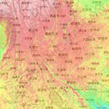
Name: Yunnan topographic map, elevation, terrain.
Location: Yunnan, China (21.14314 97.52746 29.22572 106.19675)
Average elevation: 1,713 m
Minimum elevation: 4 m
Maximum elevation: 6,431 m
Yunnan is situated in a mountainous area, with high elevations in the northwest and low elevations in the southeast. Most of the population lives in the eastern part of the province. In the west, the altitude can vary from the mountain peaks to river valleys by as much as 3,000 metres (9,800 ft). Yunnan is rich in natural resources and has the largest diversity of plant life in China. Of the approximately 30,000 species of higher plants in China, Yunnan has perhaps 17,000 or more. Yunnan's reserves of aluminium, lead, zinc and tin are the largest in China, and there are also major reserves of copper and nickel.
Other topographic maps
Click on a map to view its topography, its elevation and its terrain.
Yingjiang County
China > Yunnan > Yingjiang County
Yingjiang County, Dehong, Yunnan, 665000, China
Average elevation: 1,428 m
Hezuo
China > Gansu > Hezuo City
Hezuo, Hezuo City, Gannan, Gansu, 747000, China
Average elevation: 3,199 m
Nuozhadu Dam
China > Yunnan > Lancang Lahu Autonomous County
Nuozhadu Dam, Lancang Lahu Autonomous County, Pu'er City, Yunnan, China
Average elevation: 843 m
Qanag
China > Tibet > Mainling City
Qanag, Mainling City, Nyingchi Prefecture, Tibet, China
Average elevation: 3,790 m
Xin'anjiang Hydropower Station
China > Zhejiang > Jiande > 滩头坞
Xin'anjiang Hydropower Station, 滩头坞, Jiande, Zhejiang, China
Average elevation: 158 m
Tarim Basin
China > Xinjiang > Qarqan County > Tazhong Town
Tarim Basin, Tazhong Town, Qarqan County, Bayingolin, Xinjiang, China
Average elevation: 1,055 m
Yellow River
China > Gansu > Maqu County > Gaoyuan Institute of Biology
Yellow River, Gaoyuan Institute of Biology, Maqu County, Gannan, Gansu, China
Average elevation: 3,505 m
Taiping District
Taiping District, Fuxin City, Liaoning, 123000, China
Average elevation: 235 m
Xi'nanci
China > Beijing > Daxing District
Xi'nanci, Daxing District, Beijing, China
Average elevation: 34 m
Yangtougang
China > Beijing > Fangshan District
Yangtougang, Fangshan District, Beijing, 102400, China
Average elevation: 61 m
Dali Bai Autonomous Prefecture
Dali Bai Autonomous Prefecture, Yunnan, China
Average elevation: 2,168 m
Heihe
China > Heilongjiang > 幸福乡
Heihe, 幸福乡, Aihui District, Heihe City, Heilongjiang, 164300, China
Average elevation: 174 m
Tianshan District
Tianshan District, Ürümqi, Xinjiang, 830000, China
Average elevation: 1,108 m
Bangshan
China > Fujian > Longhai District
Bangshan, Longhai District, Zhangzhou City, Fujian, China
Average elevation: 37 m
Haixi Mongol and Tibetan Autonomous Prefecture
Haixi Mongol and Tibetan Autonomous Prefecture, Qinghai, China
Average elevation: 3,739 m