
Stroud topographic map
Interactive map
Click on the map to display elevation.
About this map
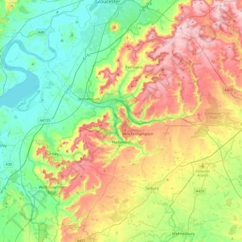
Name: Stroud topographic map, elevation, terrain.
Location: Stroud, Gloucestershire, England, United Kingdom (51.58984 -2.54081 51.85046 -2.06871)
Average elevation: 113 m
Minimum elevation: 0 m
Maximum elevation: 302 m
Other topographic maps
Click on a map to view its topography, its elevation and its terrain.
Gloucester
United Kingdom > England > Gloucestershire
Gloucester, Gloucestershire, England, United Kingdom
Average elevation: 36 m
Tidenham Chase
United Kingdom > England > Gloucestershire > Forest of Dean
Tidenham Chase, Forest of Dean, Gloucestershire, England, NP16 7JW, United Kingdom
Average elevation: 112 m
Fossil Beach
United Kingdom > England > Gloucestershire > Forest of Dean > Sedbury
Fossil Beach, Tidenham, Sedbury, Forest of Dean, Gloucestershire, England, NP16 7FD, United Kingdom
Average elevation: 14 m
Kings Barton
United Kingdom > England > Gloucestershire > Gloucester
Kings Barton, Gloucester, Gloucestershire, England, GL1 1QT, United Kingdom
Average elevation: 20 m
Moreton-in-Marsh
United Kingdom > England > Gloucestershire > Cotswold District
Moreton-in-Marsh, Cotswold District, Gloucestershire, England, United Kingdom
Average elevation: 135 m
Forest of Dean
United Kingdom > England > Gloucestershire
Forest of Dean, Gloucestershire, England, GL18 1EF, United Kingdom, Eden Hill
Average elevation: 32 m
Prestbury
United Kingdom > England > Gloucestershire > Cheltenham
Prestbury, Cheltenham, Gloucestershire, England, GL52 3EL, United Kingdom
Average elevation: 110 m
Upper Soudley
United Kingdom > England > Gloucestershire > Forest of Dean
Upper Soudley, Forest of Dean, Gloucestershire, England, GL14 2TS, United Kingdom
Average elevation: 138 m
Hucclecote Green
United Kingdom > England > Gloucestershire > Gloucester
Hucclecote Green, Gloucester, Gloucestershire, England, GL3 3RB, United Kingdom
Average elevation: 53 m
Tewkesbury
United Kingdom > England > Gloucestershire > Tewkesbury
Tewkesbury, Gloucestershire, England, United Kingdom
Average elevation: 18 m
Strand
United Kingdom > England > Gloucestershire > Forest of Dean > Westbury-on-Severn
Strand, Westbury-on-Severn, Forest of Dean, Gloucestershire, England, GL14 1PG, United Kingdom
Average elevation: 14 m
Shadwell
United Kingdom > England > Gloucestershire > Stroud > Uley
Shadwell, Uley, Stroud, Gloucestershire, England, GL11 5BW, United Kingdom
Average elevation: 165 m
Blockley
United Kingdom > England > Gloucestershire > Cotswold District
Blockley, Cotswold District, Gloucestershire, England, United Kingdom
Average elevation: 163 m
Taylors Hill
United Kingdom > England > Gloucestershire > Cotswold District
Taylors Hill, Cotswold District, Gloucestershire, England, GL54 4BJ, United Kingdom
Average elevation: 237 m
Cirencester
United Kingdom > England > Gloucestershire > Cotswold District > Cirencester
Cirencester, Cotswold District, Gloucestershire, England, United Kingdom
Average elevation: 128 m
Stonehouse
United Kingdom > England > Gloucestershire > Stonehouse
Stonehouse, Stroud, Gloucestershire, South West England, England, GL10 2, United Kingdom
Average elevation: 75 m
The Noose
United Kingdom > England > Gloucestershire > Forest of Dean > Awre
The Noose, Awre, Forest of Dean, Gloucestershire, South West England, England, GL14 1, United Kingdom
Average elevation: 5 m
Prestbury
United Kingdom > England > Gloucestershire > Cheltenham
Prestbury, Cheltenham, Gloucestershire, England, United Kingdom
Average elevation: 63 m