
Massachusetts topographic map
Interactive map
Click on the map to display elevation.
About this map
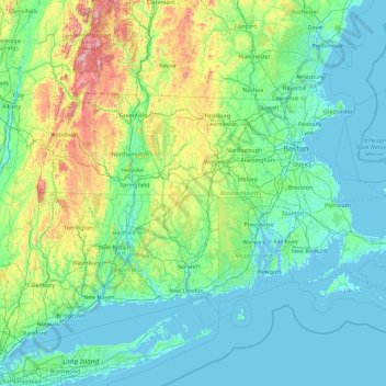
Name: Massachusetts topographic map, elevation, terrain.
Location: Massachusetts, United States (41.18886 -73.50821 42.88678 -69.86010)
Average elevation: 128 m
Minimum elevation: -7 m
Maximum elevation: 1,159 m
Despite its small size, Massachusetts features numerous topographically distinctive regions. The large coastal plain of the Atlantic Ocean in the eastern section of the state contains Greater Boston, along with most of the state's population, as well as the distinctive Cape Cod peninsula. To the west lies the hilly, rural region of Central Massachusetts, and beyond that, the Connecticut River Valley. Along the western border of Western Massachusetts lies the highest elevated part of the state, the Berkshires, forming a portion of the northern terminus of the Appalachian Mountains.
Other topographic maps
Click on a map to view its topography, its elevation and its terrain.
Hennepin County
Hennepin County, Minnesota, United States
Average elevation: 280 m
Litchfield County
United States > Connecticut > Northwest Hills Planning Region
Litchfield County, Northwest Hills Planning Region, Connecticut, United States
Average elevation: 252 m
Moore County
United States > North Carolina
Moore County, North Carolina, United States
Average elevation: 127 m
Baltimore County
Baltimore County, Maryland, United States
Average elevation: 123 m
Largo
United States > Florida > Pinellas County
Largo, Pinellas County, Florida, United States
Average elevation: 9 m
Puyallup
United States > Washington > Pierce County
Puyallup, Pierce County, Washington, United States
Average elevation: 66 m
Everett
United States > Washington > Snohomish County
Everett, Snohomish County, Washington, United States
Average elevation: 66 m
Wake County
United States > North Carolina
Wake County, North Carolina, United States
Average elevation: 96 m
Fargo
United States > North Dakota > Cass County
Fargo, Cass County, North Dakota, United States
Average elevation: 277 m
Princeton
United States > Kentucky > Caldwell County
Princeton, Caldwell County, Kentucky, United States
Average elevation: 155 m
Beaverton
United States > Oregon > Washington County
Beaverton, Washington County, Oregon, United States
Average elevation: 106 m
Buffalo
United States > Montana > Fergus County
Buffalo, Fergus County, Montana, 59418, United States
Average elevation: 1,320 m
West Hartford
United States > Connecticut > Capitol Planning Region
West Hartford, Capitol Planning Region, Connecticut, United States
Average elevation: 60 m
Hickory
United States > North Carolina > Catawba County
Hickory, Catawba County, North Carolina, United States
Average elevation: 317 m
Tolleson
United States > Arizona > Maricopa County
Tolleson, Maricopa County, Arizona, United States
Average elevation: 310 m
Roseville
United States > California > Placer County
Roseville, Placer County, California, United States
Average elevation: 61 m
Redwood City
United States > California > San Mateo County
Redwood City, San Mateo County, California, United States
Average elevation: 32 m
Thomas Terrace
United States > Virginia > Campbell County
Thomas Terrace, Campbell County, Virginia, United States
Average elevation: 226 m
McCracken County
McCracken County, Kentucky, United States
Average elevation: 119 m
Cannondale
United States > Connecticut > Western Connecticut Planning Region > Wilton
Cannondale, Wilton, Western Connecticut Planning Region, Connecticut, 06897, United States
Average elevation: 110 m
Seven Lakes
United States > North Carolina > Moore County
Seven Lakes, Moore County, North Carolina, United States
Average elevation: 168 m
Port Charlotte
United States > Florida > Charlotte County
Port Charlotte, Charlotte County, Florida, 33952, United States
Average elevation: 4 m
Buckingham
United States > Florida > Lee County > Buckingham
Buckingham, Lee County, Florida, 33905, United States
Average elevation: 7 m
Lynnwood
United States > Washington > Snohomish County
Lynnwood, Snohomish County, Washington, 98037, United States
Average elevation: 121 m
Mount Vernon
United States > Washington > Skagit County
Mount Vernon, Skagit County, Washington, 98273, United States
Average elevation: 37 m
Ocean County
Ocean County, New Jersey, United States
Average elevation: 15 m
Arbuckle
United States > California > Colusa County
Arbuckle, Colusa County, California, 95912, United States
Average elevation: 42 m
Oceanview
United States > South Carolina > Charleston County
Oceanview, Charleston County, South Carolina, 29412, United States
Average elevation: 2 m
Bridge Creek
United States > Oklahoma > Grady County
Bridge Creek, Grady County, Oklahoma, United States
Average elevation: 411 m
Leavenworth County
Leavenworth County, Kansas, United States
Average elevation: 290 m
Lake Forest
United States > California > Orange County
Lake Forest, Orange County, California, United States
Average elevation: 193 m
Ophir
United States > Utah > Tooele County
Ophir, Tooele County, Utah, United States
Average elevation: 2,232 m
Santa Ana Pueblo
United States > New Mexico > Sandoval County
Santa Ana Pueblo, Sandoval County, New Mexico, United States
Average elevation: 1,576 m
San Antonio
United States > Texas > Bexar County
San Antonio, Bexar County, Texas, United States
Average elevation: 247 m
Rudeston
United States > New York > Hamilton County
Rudeston, Town of Arietta, Hamilton County, New York, United States
Average elevation: 533 m
Good
United States > Virginia > Frederick County
Good, Frederick County, Virginia, 22625, United States
Average elevation: 356 m
Hollis Park
United States > Arizona > Maricopa County > Tempe
Hollis Park, Tempe, Maricopa County, Arizona, United States
Average elevation: 362 m
Starks
United States > Maine > Somerset County
Starks, Somerset County, Maine, United States
Average elevation: 129 m
Little Egg Harbor
United States > New Jersey > Ocean County > Little Egg Harbor Township
Little Egg Harbor, Little Egg Harbor Township, Ocean County, New Jersey, United States
Average elevation: 2 m
Park Ridge
United States > Illinois > Cook County
Park Ridge, Maine Township, Cook County, Illinois, 60068, United States
Average elevation: 198 m
Crescent City
United States > California > Del Norte County
Crescent City, Del Norte County, California, United States
Average elevation: 31 m
Bennet Park
United States > Michigan > Eaton County > Charlotte
Bennet Park, Charlotte, Eaton Township, Eaton County, Michigan, United States
Average elevation: 277 m
Easton
United States > Massachusetts > Bristol County
Easton, Bristol County, Massachusetts, United States
Average elevation: 47 m
Evergreen
United States > Colorado > Jefferson County
Evergreen, Jefferson County, Colorado, 80457, United States
Average elevation: 2,301 m
Whidbey Island
United States > Washington > Island County
Whidbey Island, Island County, Washington, United States
Average elevation: 45 m