
Make a donation
Gear up for your next adventure:
As an Amazon Associate, this site earns from qualifying purchases at no extra cost to you.
Sarek topographic map
Click on the map to display elevation.
Make a donation
Gear up for your next adventure:
As an Amazon Associate, this site earns from qualifying purchases at no extra cost to you.
Sarek
Sarek National Park is the most mountainous region in Sweden and it is the part of the country that mostly resembles an alpine countryside. Within the park are 19 summits higher than 1,900 m (6,200 ft), the most noted being the second highest summit in Sweden after the Kebnekaise – the Sarektjåkkå with a height of 2,089 m (6,854 ft). The lowest altitude in the park is found in the southwest, near Lake Rittakjaure, at 477 m (1,565 ft).
Make a donation
Gear up for your next adventure:
As an Amazon Associate, this site earns from qualifying purchases at no extra cost to you.
About this map
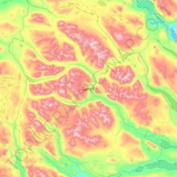
Name: Sarek topographic map, elevation, terrain.
Location: Sarek, Sweden (67.03219 17.07337 67.56400 18.28354)
Average elevation: 994 m
Minimum elevation: 375 m
Maximum elevation: 2,052 m
Make a donation
Gear up for your next adventure:
As an Amazon Associate, this site earns from qualifying purchases at no extra cost to you.
Other topographic maps
Click on a map to view its topography, its elevation and its terrain.
Make a donation
Gear up for your next adventure:
As an Amazon Associate, this site earns from qualifying purchases at no extra cost to you.
Abisko
Permafrost is common around the village albeit this low altitude permafrost is disappearing because of global warming and increased snowfall.
Average elevation: 395 m
Make a donation
Gear up for your next adventure:
As an Amazon Associate, this site earns from qualifying purchases at no extra cost to you.
Kopparberg
Although Kopparberg is slightly further south, it is located at a slightly higher elevation 6 kilometres (3.7 mi) south-east, rendering likely values very similar. Winter highs usually average just below freezing, and frosts are frequent from October through April. Summers are very tempered, compared to both…
Average elevation: 196 m
Make a donation
Gear up for your next adventure:
As an Amazon Associate, this site earns from qualifying purchases at no extra cost to you.
Make a donation
Gear up for your next adventure:
As an Amazon Associate, this site earns from qualifying purchases at no extra cost to you.
Make a donation
Gear up for your next adventure:
As an Amazon Associate, this site earns from qualifying purchases at no extra cost to you.
Östersund
Though Östersund is in fact affected by the Gulf Stream, it lacks the high frequency of rain or snow following the currents. This is due to the Scandinavian Mountain Range acting as a natural barrier, receiving most of the precipitation, giving Östersund and the surrounding area a rain deficit. Another issue…
Average elevation: 341 m
Make a donation
Gear up for your next adventure:
As an Amazon Associate, this site earns from qualifying purchases at no extra cost to you.
Make a donation
Gear up for your next adventure:
As an Amazon Associate, this site earns from qualifying purchases at no extra cost to you.