
Jalisco topographic map
Interactive map
Click on the map to display elevation.
Jalisco
Jalisco is made up of a diverse terrain that includes forests, beaches, plains, and lakes. Altitudes in the state vary from 0 to 4,300 meters (0 to 14,110 ft) above sea level, from the coast to the top of the Nevado de Colima. The Jalisco area contains all five of Mexico's natural ecosystems: arid and semi arid scrublands, tropical evergreen forests, tropical deciduous and thorn forests, grasslands and mesquite grasslands, and temperate forests with oaks, pines and firs. Over 52% of the bird species found in Mexico live in the state, with 525, 40% of Mexico's mammals with 173 and 18% of its reptile species. There are also 7,500 species of veined plants. One reason for its biodiversity is that it lies in the transition area between the temperate north and tropical south. It also lies at the northern edge of the Sierra Madre del Sur and is on the Trans-Mexican Volcanic Belt, which provides a wide variety of ecological conditions from tropical rainforest conditions to semi arid areas to areas apt for conifer forests.
About this map
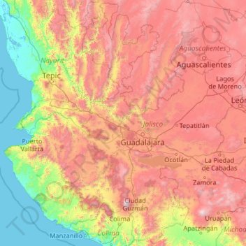
Name: Jalisco topographic map, elevation, terrain.
Location: Jalisco, Mexico (18.92587 -105.69540 22.75025 -101.51054)
Average elevation: 1,301 m
Minimum elevation: -2 m
Maximum elevation: 4,016 m
Other topographic maps
Click on a map to view its topography, its elevation and its terrain.
Amacuzac
San Gabriel las Palmas has 2,955 residents. Its principal economic activity is agriculture. It is 44 kilometres (27 mi) from Cuernavaca and 4.3 kilometres (2.7 mi) from the municipal seat. There is one preschool, two elementary schools (grades 1-6), and a middle school (grades 7-9). It is located at an…
Average elevation: 954 m
La Desviación (Colonia Vicente Guerrero)
Mexico > Veracruz > Úrsulo Galván > Zempoala
Average elevation: 16 m
Pachuca
Mexico > Hidalgo > Pachuca de Soto
Pachuca has a semi-arid climate (Köppen climate classification BSk). The climate is cool with high rainfall and occasional hail during the summer months and dry conditions during the winter. The coldest month is January, with an average high of 20 °C (68 °F) and an average low of 3 °C (37 °F). Winter…
Average elevation: 2,459 m
Tijuana
Mexico > Baja California > Municipio de Tijuana
Housing development in the Tijuana Hills has led to eradication of many seasonal mountain streams. This lack of natural drainage makes places within the city vulnerable to landslides during the rainy season. The varied terrain of Tijuana gives the city elevation extremes that range from sea level to 790 meters…
Average elevation: 141 m
Tuxtla Gutiérrez
Mexico > Chiapas > Tuxtla Gutiérrez
On the edge of the city is the El Zapotal Ecological Reserve, best known as the home of the Zoológico Miguel Alvarez del Toro Zoo, often referred to as the ZooMAT. The zoo covers 100 hectares and was founded by Miguel Alvarez del Toro in 1942. He was also the director for over fifty years. ZooMAT is…
Average elevation: 817 m
Tequila
Tequila is one of the 124 municipalities of Jalisco, located just west of the center of the state. Its territory extends for 1689.11km2, with elevations that vary between 700 and 2,900 meters above sea level. The municipality borders with the main metropolitan region of Guadalajara to the east (Zapopan), and…
Average elevation: 1,267 m
Santiago Tianguistenco
The municipality lies in the Trans-Mexican Volcanic Belt in the sub-province of the Lakes and Volcanoes of Anahuac. 35% of the municipality is mountainous, 30% is arable and the rest is developed. The topography of the municipality varies due to its size. The eastern portions are highest as they are in the…
Average elevation: 2,645 m
Nevado de Toluca
Mexico > State of Mexico > Toluca
Most of the other sites are found on the crater's walls and peaks. One of the sites is called Xicotepec which is at the top of a rocky dome known as the Cerro de Ombligo (Spanish for "the navel"). Principally green obsidian blades and multicolored ceramic has been found here. On the north side of the crater is…
Average elevation: 4,280 m
Toluca
Mexico > State of Mexico > Toluca
The Lerma River flows from Lake Almoloya del Río through the center of the municipality towards the west, flowing into Lake Chapala. From this point westward the river takes the name of Río Grande de Santiago. And it goes from this lake to the Pacific Ocean in the state of Nayarit. The river is about 1,180…
Average elevation: 2,729 m
Aguascalientes
Mexico > Aguascalientes > Municipio de Aguascalientes
The Aguascalientes Bicentenary Velodrome, designed by Peter Junek, hosted the 2010 Pan American Track Championships. At an Elevation of 1887m, the Velodrome is a frequent location for attempts at breaking the Cycling Hour Record
Average elevation: 1,956 m
Mexico City
Mexico > Mexico City > Mexico City
Mexico City is located in the Valley of Mexico, sometimes called the Basin of Mexico. This valley is located in the Trans-Mexican Volcanic Belt in the high plateaus of south-central Mexico. It has a minimum altitude of 2,200 meters (7,200 feet) above sea level and is surrounded by mountains and volcanoes that…
Average elevation: 2,321 m
Chihuahua
Mexico > Chihuahua > Municipio de Chihuahua
Chihuahua lies on the western side of the Chihuahuan Desert ecoregion and as such has a semiarid climate (Köppen climate classification BSh). However, it is not as hot as most of the lower elevated portions of the desert to the east owing to an altitude of almost 1,500 metres (4,900 feet) above sea level.
Average elevation: 1,555 m
Parque Nacional Molino de Flores Netzahualcoyotl
Mexico > State of Mexico > Texcoco > Xocotlán
Average elevation: 2,313 m
San Francisco del Rincón
Mexico > Guanajuato > San Francisco del Rincón
The settlement was founded as San Francisco del Tule on January 21, 1607 by a group of families of the Purépecha and Hñähñu (Otomi) ethnicities. It was declared a villa (town) on September 6, 1865 and a city on March 27, 1867. It is located at 21°01′22″N 101°51′36″W / 21.02278°N…
Average elevation: 1,767 m
San Cristóbal Zapotitlán
Mexico > Jalisco > Jocotepec > San Cristóbal Zapotitlán
Average elevation: 1,552 m
Saltillo
El Cerro del Pueblo (The Town Hill) and its 4-metre (13 ft) cross overlook the city. The city's elevation makes it colder and windier than the neighboring city of Monterrey. Saltillo lies in the Chihuahuan Desert near the city of Arteaga. The city is flanked by the Zapalinamé mountains, which are part of the…
Average elevation: 1,857 m
Mazatlán
At the edge of Mazatlán and Concordia runs the Sierra del Metate and Panuco. In this county, the Sierra Madre Occidental is diverted to penetrate Durango, leaving before some detachments, such as the Sierra de San Juan and the Friars, and constitutes, in of its topography, the following hilly areas.
Average elevation: 19 m
San Lorenzo Tlalmimilolpan
Mexico > State of Mexico > San Lorenzo Tlalmimilolpan
Average elevation: 2,274 m
Villahermosa
Villahermosa is located in the southeast of Mexico between the rivers Grijalva and Carrizal. The average elevation of the city is 10 meters above sea level. The city also has several lagoons, the largest and most important of them being La Laguna de las Ilusiones (Illusions Lagoon).
Average elevation: 9 m
Hermosillo
Mexico > Sonora > Hermosillo
The Cerro de la Campana mountain is one of the symbols of Hermosillo. Its summit is 350 metres (1,150 ft) above the valley floor and contains a lookout called El Caracol, which was inaugurated in 1909. There are two theories as to the origin of the mountain's name. One states that it is from a peculiar…
Average elevation: 248 m