
Mahakali topographic map
Interactive map
Click on the map to display elevation.
About this map
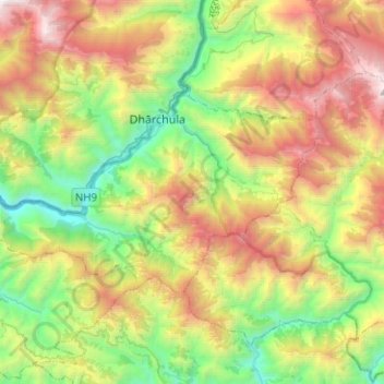
Name: Mahakali topographic map, elevation, terrain.
Location: Mahakali, Darchula, Sudurpashchim Pradesh, Nepal (29.75078 80.39605 29.86454 80.64729)
Average elevation: 1,950 m
Minimum elevation: 705 m
Maximum elevation: 3,906 m
Other topographic maps
Click on a map to view its topography, its elevation and its terrain.
Annapurna I
Nepal > Gandaki Province > Myagdi
The mountain is named after Annapurna, the Hindu goddess of food and nourishment, who is said to reside there. The name Annapurna is derived from the Sanskrit-language words purna ("filled") and anna ("food"), and can be translated as "everlasting food". Many streams descending from the slopes of the Annapurna…
Average elevation: 7,126 m
Naudanda
Nepal > Gandaki Province > Kaski
Tourists visit here for recreation and the natural environment. This location is famous for its view of the Annapurna range on one side and Phewa lake and Pokhara city on the other. It is at the altitude of 1,443 meters above sea level. Naudada is also a popular destination for birdwatchers. It is one of the…
Average elevation: 1,308 m
Dingboche
Nepal > Koshi Province > Solukhumbu
Dingboche is a Sherpa village at an elevation of 4,410 m (14,470 ft) in the Khumbu region of northeastern Nepal. Its population was estimated at approximately 200 in 2011.
Average elevation: 4,600 m
Namche Bazaar
Nepal > Koshi Province > Solukhumbu
Namche Bazaar is popular with trekkers in the Khumbu region, especially for altitude acclimatization, and is the gateway to the high Himalaya. The town has a number of lodgings and stores catering to the needs of visitors as well as a number of internet cafés. There are German bakeries, little cafes and many…
Average elevation: 3,526 m
Mount Everest
Nepal > Koshi Province > Solukhumbu
Mount Everest (Nepali: सगरमाथा, romanized: Sagarmāthā; Tibetan: Chomolungma ཇོ་མོ་གླང་མ; Chinese: 珠穆朗玛峰; pinyin: Zhūmùlǎngmǎ Fēng) is Earth's highest mountain above sea level, located in the Mahalangur Himal sub-range of the Himalayas. The China–Nepal…
Average elevation: 7,850 m
Khumjung
Khumjung (Nepali: खुम्जुंग) is a village in Khumbu Pasanglhamu rural municipality of Solukhumbu District in Province No. 1 of north-eastern Nepal. It is located in the Khumbu subregion inside Sagarmatha National Park, a world heritage site. The village is at an elevation of 3,790 metres above…
Average elevation: 3,888 m
Kangchenjunga
Kangchenjunga Main is the highest elevation of the Brahmaputra River basin, which forms part of the southeast Asian monsoon regime and is among the globally largest river basins. Kangchenjunga is one of six peaks above 8,000 m (26,000 ft) located in the basin of the Kosi River, which is among the largest…
Average elevation: 7,724 m
Mount Everest
Nepal > Eastern Development Region > Tashi Dzom > Khumjung
The current official elevation of 8,848 m (29,029 ft), recognised by China and Nepal, was established by a 1955 Indian survey and subsequently confirmed by a Chinese survey in 1975.
Average elevation: 7,841 m
Kathmandu
Nepal > Bagmati Province > Kathmandu
Kathmandu, also known as the city of temples, with one of the oldest Pagodas known as Pashupatinath Temple, stands at an elevation of approximately 1,400 metres (4,600 feet) above sea level in the bowl-shaped Kathmandu Valley in central Nepal. The valley is historically termed as "Nepal Mandala" and has been…
Average elevation: 1,538 m