
Make a donation
Mount Nugong topographic map
Click on the map to display elevation.
Make a donation
About this map
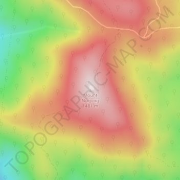
Name: Mount Nugong topographic map, elevation, terrain.
Location: Mount Nugong, Shire of East Gippsland, Victoria, Australia (-37.22835 147.89671 -37.22825 147.89681)
Average elevation: 1,233 m
Minimum elevation: 927 m
Maximum elevation: 1,466 m
Victoria trails, hiking, mountain biking, running and outdoor activities
Make a donation
Other topographic maps
Click on a map to view its topography, its elevation and its terrain.
City of Melbourne
Melbourne's topography is characterized by a diverse landscape that transitions from flat coastal plains to rolling hills and mountainous regions. The city is situated at the northern end of Port Phillip Bay, where the terrain is predominantly flat, facilitating urban development. As one moves eastward, the…
Average elevation: 18 m
Melbourne
Melbourne is also prone to isolated convective showers forming when a cold pool crosses the state, especially if there is considerable daytime heating. These showers are often heavy and can include hail, squalls, and significant drops in temperature, but they often pass through very quickly with a rapid…
Average elevation: 185 m
Make a donation
Make a donation
Make a donation
Make a donation
Make a donation
Make a donation
Trentham
Trentham is a town in the Shire of Hepburn and Shire of Moorabool local government area of West Central Victoria, Australia. At the 2016 census, Trentham had a population of 1180, with a median age of 55 years. Located at an altitude of 700 metres (2,297 ft), the town is 87 kilometres (54 miles) north-west of…
Average elevation: 702 m
Make a donation
Make a donation
Make a donation
Make a donation
Grampians National Park
Mount William is known within the gliding community for the "Grampians Wave", a weather phenomenon that sometimes enables glider pilots to reach extreme altitudes of the order of 28,000 ft (8,500 m). This predominantly occurs during the months of May, June, September and October when strong westerly winds flow…
Average elevation: 262 m
Port Phillip
Port Phillip's mostly flat topography and moderate waves make perfect conditions for recreational swimming, kitesurfing, windsurfing, sailing, boating, snorkeling, scuba diving, stand up paddle boarding (SUP) and other sports.
Average elevation: 18 m
Make a donation
Frankston
Australia > Victoria > Melbourne
Olivers Hill is the most prominent elevation in Frankston which rises to 55 metres above sea level (180 feet) at its highest point in the suburb. Its origins date to approximately 415 to 360 million years ago. Its base is Mount Eliza Granite dating from the Devonian period, which was covered in lava tuffs in…
Average elevation: 40 m
Castlemaine
The Castlemaine goldfields' legendary prosperity raised expectations of Castlemaine becoming Victoria's second city. That is reflected in imposing buildings erected in the town's first few years. Though the rich alluvial diggings were largely exhausted within 15–20 years causing the town's population to…
Average elevation: 319 m
Make a donation
Make a donation
Mount Buller
Due to its far south-western location in the alpine region, Mount Buller is more susceptible to cold airmasses which allow it to record some of the lowest maximum temperatures and daytime readings in the country, despite being considerably lower in elevation than other mountain sites to the north-east. On 5…
Average elevation: 824 m
Make a donation
Reedy Creek
Reedy Creek is a locality in central Victoria, Australia. The locality is in the Shire of Mitchell local government area, 99 kilometres (62 mi) north of the state capital, Melbourne. It is at 358 metres (1175 feet) elevation. It is approximately 15 minutes from Broadford, Vic, 3658.
Average elevation: 375 m
Make a donation
Make a donation
Make a donation
Make a donation
Make a donation
Make a donation