
Shigatse Prefecture topographic map
Interactive map
Click on the map to display elevation.
Shigatse Prefecture
Shigatse Peace Airport began operations on 30 October 2010 after an Airbus A319 landed safely, making it Tibet's fifth commercial airport. It is located 43 kilometres from Samzhubzê District at Jangdam Township at an elevation of 3,782 metres. The airport will be capable of supporting 230,000 passengers annually by 2020.
About this map
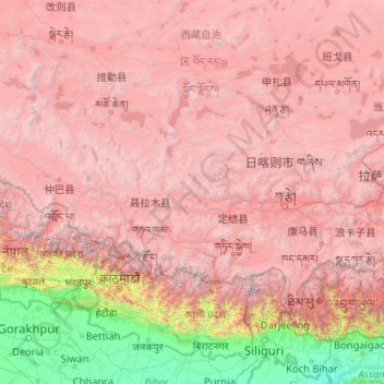
Name: Shigatse Prefecture topographic map, elevation, terrain.
Location: Shigatse Prefecture, Tibet, China (27.21205 82.09907 31.80997 90.34500)
Average elevation: 3,772 m
Minimum elevation: 23 m
Maximum elevation: 8,097 m
Other topographic maps
Click on a map to view its topography, its elevation and its terrain.
Cho Oyu
China > Tibet > Tingri County
Cho Oyu's height was originally measured at 26,750 feet (8,150 m) and at the time of the first ascent it was considered the 7th highest mountain on earth, after Dhaulagiri at 8,167 metres (26,795 ft) (Manaslu, now 8,156 metres (26,759 ft), was also estimated lower at 26,658 feet (8,125 m)). A 1984 estimate of…
Average elevation: 7,339 m
Lhasa
Lhasa has an elevation of about 3,600 m (11,800 ft) and lies in the centre of the Tibetan Plateau with the surrounding mountains rising to 5,500 m (18,000 ft). The air only contains 68 percent of the oxygen compared to sea level. The Lhasa River, also Kyi River or Kyi Chu, a tributary of the Yarlung Zangbo…
Average elevation: 4,380 m
Nyingchi
The average elevation of Nyingchi is 3,040 meters (9,974 feet), which is the lowest compared with the other prefectures in Tibet. So, the risk of getting high-altitude sickness is relatively lower than other parts on the plateau. Guangdong province announced in 2012 that it plans to invest more than RMB 400…
Average elevation: 4,035 m