
Hanging Rock topographic map
Interactive map
Click on the map to display elevation.
About this map
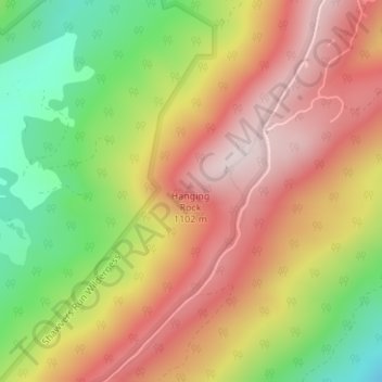
Name: Hanging Rock topographic map, elevation, terrain.
Location: Hanging Rock, Craig County, Virginia, 24131, United States (37.56258 -80.19955 37.56268 -80.19945)
Average elevation: 937 m
Minimum elevation: 680 m
Maximum elevation: 1,151 m
Other topographic maps
Click on a map to view its topography, its elevation and its terrain.
Cape Charles
United States > Virginia > Northampton County > Cape Charles
Cape Charles lies on a peninsula and is surrounded by water on three sides. The town is situated directly on the Chesapeake Bay, bordered by King's Creek to the north and Old Plantation Creek to the south. The land in town is low lying and relatively flat, with the highest point of elevation at 15 feet, and a…
Average elevation: 2 m
Martinsville
United States > Virginia > Martinsville
According to the United States Census Bureau, the city has a total area of 11.0 square miles (28.5 km2), of which 11.0 square miles (28.5 km2) is land and 0.1 square miles (0.3 km2) (0.5%) is water. The north side of the city has the highest average elevation. The east side slopes gradually down to the Smith…
Average elevation: 259 m
Carroll County
The first European settlers arrived in the region in the mid 18th century. These were primarily Scotch-Irish pioneers, who were used to high mountain altitudes. However, early settlement was slow, mostly due to the poor agricultural soil of the area. As a result, lead mining was one of the first economic…
Average elevation: 709 m
Sterling
United States > Virginia > Loudoun County
According to the USGS, Sterling has an average elevation of 289 feet (88 m) above sea level. The original center of Sterling is located at 39°00'22.4"N 77°25'43.0"W. Sterling is part of the Chesapeake Bay watershed, and Greater Sterling borders the Potomac River.
Average elevation: 97 m
Martinsville
According to the United States Census Bureau, the city has a total area of 11.0 square miles (28.5 km2), of which 11.0 square miles (28.5 km2) is land and 0.1 square miles (0.3 km2) (0.5%) is water. The north side of the city has the highest average elevation. The east side slopes gradually down to the Smith…
Average elevation: 259 m
Roanoke
Though located along the Blue Ridge Mountains at elevations exceeding 900 ft (270 m), Roanoke lies in the humid subtropical climate zone (Köppen Cfa), with four distinct, but generally mild, seasons; it is located in USDA hardiness zone 7b, with the suburbs falling in zone 7a. Extremes in temperature have…
Average elevation: 333 m
Painter
United States > Virginia > Accomack County
It lies at an elevation of 36 feet.[4]
Average elevation: 10 m
Virginia Beach
According to the United States Census Bureau, the city has a total area of 497 square miles (1,290 km2), of which 249 square miles (640 km2) is land and 248 square miles (640 km2) (49.9%) is water. It is the largest city in Virginia by total area and third-largest city by land area. The average elevation is 12…
Average elevation: 2 m