
Cathedral Rock topographic map
Interactive map
Click on the map to display elevation.
About this map
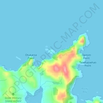
Name: Cathedral Rock topographic map, elevation, terrain.
Location: Cathedral Rock, Waikato, New Zealand (-36.58300 175.77507 -36.58183 175.77747)
Average elevation: 15 m
Minimum elevation: 0 m
Maximum elevation: 121 m
Other topographic maps
Click on a map to view its topography, its elevation and its terrain.
Māhoenui
New Zealand > Waikato > Waitomo District
Māhoenui is located in the King Country approx 50 kilometres (31 mi) inland from the west coast of the North Island, the topography is hilly to mountainous, with small alluvial areas near the streams and river.
Average elevation: 113 m
Kuranui
New Zealand > Waikato > Matamata Piako District > Morrinsville > Kuranui
Average elevation: 43 m