
City of Brisbane topographic map
Interactive map
Click on the map to display elevation.
City of Brisbane
Brisbane's topography is characterized by a series of hills and ranges that define its landscape. The city is situated on a low-lying floodplain, with the Brisbane River meandering through its heart, creating a winding course with many steep curves from the southwest to its mouth at Moreton Bay in the east. Elevations within the city include Mount Coot-tha, reaching up to 300 meters (984 feet), and other prominent rises such as Mount Gravatt, Toohey Mountain, Mount Petrie, Highgate Hill, Mount Ommaney, Stephens Mountain, and Whites Hill, which are dotted across the city. The D'Aguilar National Park, encompassing the D'Aguilar Range, bounds the north-west of Brisbane's built-up area and contains taller peaks like Mount Nebo, Camp Mountain, Mount Pleasant, Mount Glorious, Mount Samson, and Mount Mee. This varied terrain contributes to Brisbane's distinctive hilly landscape, with urban areas, including the central business district, partially elevated by spurs of the Herbert Taylor Range.
About this map
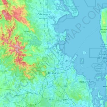
Name: City of Brisbane topographic map, elevation, terrain.
Location: City of Brisbane, Queensland, Australia (-27.66022 152.67969 -27.02201 153.46828)
Average elevation: 71 m
Minimum elevation: -3 m
Maximum elevation: 750 m
Queensland trails, hiking, mountain biking, running and outdoor activities
Other topographic maps
Click on a map to view its topography, its elevation and its terrain.
Toowoomba
The city occupies the edge of the range and the low ridges behind it. Two valleys run north from the southern boundary, each arising from springs either side of Middle Ridge near Spring Street at an altitude of around 680 m. These waterways, East Creek and West Creek, flow together just north of the CBD to…
Average elevation: 458 m
Caloundra
Australia > Queensland > Sunshine Coast Regional
Caloundra, located on Queensland's Sunshine Coast, features a diverse coastal topography characterized by sandy beaches, rocky headlands, and nearby elevated terrains. The suburb of Kings Beach exemplifies this diversity, with its sandy shoreline to the south and southeast, and a rocky headland rising to about…
Average elevation: 5 m
Warwick
Australia > Queensland > Warwick
Warwick has a humid subtropical climate (Köppen Cfa) with hot summers and cool to cold winters. It is slightly cooler and less humid than the proximate southeast Queensland coast due to its inland, elevation location. Frost is present in winter. The climate bears similarities with Richmond, an inland suburb…
Average elevation: 517 m
Cairns
South of Smithfield and inland from the Northern Beaches along the edge of the Barron River flood plain are the suburbs of Caravonica, Kamerunga, Freshwater, and Stratford. This area is sometimes referred to as Freshwater Valley, though it is actually the lower part of Redlynch Valley; further up the valley…
Average elevation: 176 m
Sunshine Coast
Australia > Queensland > Sunshine Coast Regional
The Sunshine Coast in Queensland, Australia, showcases a diverse topography that harmoniously blends coastal plains with rugged hinterlands. Along its eastern edge, the region features expansive sandy beaches and coastal dunes that transition smoothly into fertile lowlands. Inland, the terrain becomes more…
Average elevation: 109 m
Stanthorpe
Australia > Queensland > Stanthorpe
Owing to its elevation, Stanthorpe features a subtropical highland climate. At an altitude of 811 metres (2,661 ft), Stanthorpe holds the record for the lowest temperature recorded in Queensland at −10.6 °C (12.9 °F) on 23 June 1961. Sleet and light snowfalls are occasionally recorded, with the most…
Average elevation: 840 m
Picnic Point
Australia > Queensland > Toowoomba
The first addition to the Picnic Point Reserve was made when the Municipal Council purchased two freehold allotments fronting both Heller and Rowbotham Streets in 1902. By 1906 the council had commenced tree-planting at Picnic Point under the supervision of Curator Harding of the Botanical gardens. A further…
Average elevation: 575 m
Caloundra
Australia > Queensland > Sunshine Coast Regional
Caloundra, located on Queensland's Sunshine Coast, features a diverse coastal topography characterized by sandy beaches, rocky headlands, and nearby elevated terrains. The suburb of Kings Beach exemplifies this diversity, with its sandy shoreline to the south and southeast, and a rocky headland rising to about…
Average elevation: 5 m