
Biéha topographic map
Interactive map
Click on the map to display elevation.
About this map
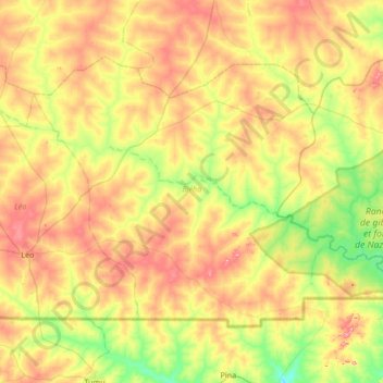
Name: Biéha topographic map, elevation, terrain.
Location: Biéha, Sissili, Central-West, Burkina Faso (10.97200 -2.09432 11.44134 -1.41670)
Average elevation: 316 m
Minimum elevation: 251 m
Maximum elevation: 403 m
Other topographic maps
Click on a map to view its topography, its elevation and its terrain.
Koala
Koala, Nagréongo, Oubritenga, Central-Plateau, Burkina Faso
Average elevation: 289 m
Bourou
Bourou, Sabou, Boulkiemdé, Central-West, Burkina Faso
Average elevation: 320 m
Komoé River
Komoé River, Wolokonto, Léraba, Waterfalls, Burkina Faso
Average elevation: 456 m