
Kadiogo topographic map
Interactive map
Click on the map to display elevation.
About this map
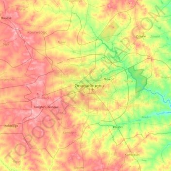
Name: Kadiogo topographic map, elevation, terrain.
Location: Kadiogo, Centre, Burkina Faso (12.05013 -1.82685 12.68505 -1.06363)
Average elevation: 311 m
Minimum elevation: 259 m
Maximum elevation: 368 m
Other topographic maps
Click on a map to view its topography, its elevation and its terrain.
Koala
Koala, Nagréongo, Oubritenga, Central-Plateau, Burkina Faso
Average elevation: 289 m
Bourou
Bourou, Sabou, Boulkiemdé, Central-West, Burkina Faso
Average elevation: 320 m
Komoé River
Komoé River, Wolokonto, Léraba, Waterfalls, Burkina Faso
Average elevation: 456 m