
Houet topographic map
Interactive map
Click on the map to display elevation.
About this map
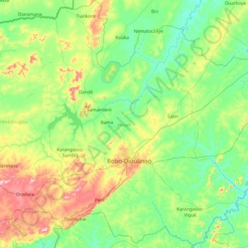
Name: Houet topographic map, elevation, terrain.
Location: Houet, Upper-Basins, 00000, Burkina Faso (10.66978 -4.77489 12.10766 -3.60384)
Average elevation: 351 m
Minimum elevation: 263 m
Maximum elevation: 688 m
Other topographic maps
Click on a map to view its topography, its elevation and its terrain.
Koala
Koala, Nagréongo, Oubritenga, Central-Plateau, Burkina Faso
Average elevation: 289 m
Bourou
Bourou, Sabou, Boulkiemdé, Central-West, Burkina Faso
Average elevation: 320 m
Komoé River
Komoé River, Wolokonto, Léraba, Waterfalls, Burkina Faso
Average elevation: 456 m