
Little Murphys Island topographic map
Interactive map
Click on the map to display elevation.
About this map
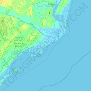
Name: Little Murphys Island topographic map, elevation, terrain.
Average elevation: 2 m
Minimum elevation: -4 m
Maximum elevation: 22 m
Other topographic maps
Click on a map to view its topography, its elevation and its terrain.
Oceanview
United States > South Carolina > Charleston County
Oceanview, Charleston County, South Carolina, 29412, United States
Average elevation: 2 m
Malady Bush Island
United States > South Carolina > Georgetown County
Malady Bush Island, Georgetown County, South Carolina, United States
Average elevation: 2 m
Rosewood Heights
United States > South Carolina > Pickens County > Liberty
Rosewood Heights, Liberty, Pickens County, South Carolina, 29657, United States
Average elevation: 291 m
Palmetto Fort
United States > South Carolina > Charleston County > Mount Pleasant
Palmetto Fort, Mount Pleasant, Charleston County, South Carolina, 29466, United States
Average elevation: 4 m
Spartanburg
United States > South Carolina > Spartanburg County
Spartanburg, Spartanburg County, South Carolina, United States
Average elevation: 234 m
Cayce
United States > South Carolina > Lexington County
Cayce, Lexington County, South Carolina, 29033, United States
Average elevation: 64 m
Coopers
United States > South Carolina > Horry County > Socastee
Coopers, Socastee, Horry County, South Carolina, 29588, United States
Average elevation: 5 m
Dunean
United States > South Carolina > Greenville County > Chestnut Hills
Dunean, Chestnut Hills, Greenville County, South Carolina, United States
Average elevation: 292 m
Bennettsville
United States > South Carolina > Marlboro County
Bennettsville, Marlboro County, South Carolina, 29512, United States
Average elevation: 50 m
Ropers Crossroads
United States > South Carolina > Edgefield County
Ropers Crossroads, Edgefield County, South Carolina, United States
Average elevation: 110 m
Seneca
United States > South Carolina > Oconee County
Seneca, Oconee County, South Carolina, United States
Average elevation: 265 m
Forest Lakes
United States > South Carolina > Charleston County
Forest Lakes, Charleston County, South Carolina, 29414, United States
Average elevation: 4 m
Oakmont
United States > South Carolina > Dorchester County
Oakmont, Dorchester County, South Carolina, 29485, United States
Average elevation: 11 m
Crosswinds
United States > South Carolina > Horry County > Red Hill
Crosswinds, Red Hill, Horry County, South Carolina, 29528, United States
Average elevation: 11 m
Vallentine Pond Dam D-3767
United States > South Carolina > Orangeburg County
Vallentine Pond Dam D-3767, Orangeburg County, South Carolina, United States
Average elevation: 66 m
Fort Mill
United States > South Carolina > York County
Fort Mill, York County, South Carolina, United States
Average elevation: 179 m
Mayo
United States > South Carolina > Spartanburg County
Mayo, Spartanburg County, South Carolina, 29368, United States
Average elevation: 252 m
River Falls
United States > South Carolina > Greenville County
River Falls, Greenville County, South Carolina, United States
Average elevation: 436 m
Lexington County
United States > South Carolina
Lexington County, South Carolina, United States
Average elevation: 116 m
Surfside Beach
United States > South Carolina > Horry County > Surfside Beach
Surfside Beach, Horry County, South Carolina, 29587, United States
Average elevation: 2 m
Horry County
United States > South Carolina
Horry County, South Carolina, United States
Average elevation: 14 m
North Hills
United States > South Carolina > Pickens County > Easley
North Hills, Easley, Pickens County, South Carolina, 29640, United States
Average elevation: 322 m
Darlington County
United States > South Carolina > Darlington County
Darlington County, South Carolina, United States
Average elevation: 53 m
Columbia
United States > South Carolina > Richland County
Columbia, Richland County, South Carolina, United States
Average elevation: 89 m
Berkeley County
United States > South Carolina
Berkeley County, South Carolina, United States
Average elevation: 11 m
Garden City Beach
United States > South Carolina > Horry County > Garden City Beach
Garden City Beach, Horry County, South Carolina, 29575:29576, United States
Average elevation: 4 m
Myrtle Beach
United States > South Carolina > Horry County > Myrtle Beach
Myrtle Beach, Horry County, South Carolina, United States
Average elevation: 4 m
Williamsburg County
United States > South Carolina
Williamsburg County, South Carolina, United States
Average elevation: 17 m
Garden Hill
United States > South Carolina > Charleston County > Charleston > Garden Hill
Garden Hill, Charleston, Charleston County, South Carolina, 29409, United States
Average elevation: 3 m
Sea Pines
United States > South Carolina > Beaufort County > Hilton Head Island > Sea Pines
Sea Pines, Hilton Head Island, Beaufort County, South Carolina, 29938, United States
Average elevation: 4 m
Sansbury Crossroads
United States > South Carolina > Florence County > Sansbury Crossroads
Sansbury Crossroads, Florence County, South Carolina, 29161, United States
Average elevation: 38 m
Warington
United States > South Carolina > Dorchester County > Summerville > Warington
Warington, Summerville, Dorchester County, South Carolina, 29483, United States
Average elevation: 23 m
Anderson County
United States > South Carolina > Anderson County
Anderson County, South Carolina, United States
Average elevation: 229 m
Spartanburg
United States > South Carolina > Spartanburg County > Spartanburg
Spartanburg, Spartanburg County, South Carolina, 29305, United States
Average elevation: 234 m
York
United States > South Carolina > York County > York > York
York, York County, South Carolina, 29745, United States
Average elevation: 196 m
Conway
United States > South Carolina > Horry County > Conway > Conway
Conway, Horry County, South Carolina, 29528, United States
Average elevation: 8 m
Lancaster County
United States > South Carolina
Lancaster County, South Carolina, United States
Average elevation: 161 m
Spartanburg County
United States > South Carolina
Spartanburg County, South Carolina, United States
Average elevation: 239 m
Gaffney
United States > South Carolina > Cherokee County > Gaffney
Gaffney, Cherokee County, South Carolina, 29342, United States
Average elevation: 225 m
Belleview
United States > South Carolina > Richland County > Columbia > Belleview
Belleview, Columbia, Richland County, South Carolina, 29220, United States
Average elevation: 79 m
East Spartanburg
United States > South Carolina > Spartanburg County > Spartanburg
East Spartanburg, Spartanburg, Spartanburg County, South Carolina, 29302, United States
Average elevation: 227 m
Charleston
United States > South Carolina > Charleston County
Charleston, Charleston County, South Carolina, United States
Average elevation: 4 m
Pelzer
United States > South Carolina > Pelzer
Pelzer, Anderson County, South Carolina, United States
Average elevation: 239 m
Williamston
United States > South Carolina > Williamston
Williamston, Anderson County, South Carolina, 29697, United States
Average elevation: 251 m
Anderson
United States > South Carolina > Anderson
Anderson, Anderson County, South Carolina, United States
Average elevation: 232 m
The Crescent
United States > South Carolina > Charleston > The Crescent
The Crescent, Charleston, Charleston County, South Carolina, 29422, United States
Average elevation: 3 m
Colleton County
United States > South Carolina
Colleton County, South Carolina, United States
Average elevation: 15 m
Conway
United States > South Carolina > Conway
Conway, Horry County, South Carolina, United States
Average elevation: 10 m
Lake Wylie
United States > South Carolina > Lake Wylie
Lake Wylie, York County, South Carolina, United States
Average elevation: 188 m
Boneo
United States > South Carolina > Abbeville County > Boneo
Boneo, Abbeville County, South Carolina, 20654, United States
Average elevation: 215 m