
Great Britain topographic map
Interactive map
Click on the map to display elevation.
About this map
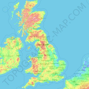
Name: Great Britain topographic map, elevation, terrain.
Location: Great Britain, United Kingdom (49.95870 -6.22788 58.67208 1.76322)
Average elevation: 52 m
Minimum elevation: -6 m
Maximum elevation: 1,233 m
Other topographic maps
Click on a map to view its topography, its elevation and its terrain.
Kingswood
United Kingdom > England > South Gloucestershire
Kingswood, South Gloucestershire, West of England, England, BS15 8LQ, United Kingdom
Average elevation: 57 m
Glazebrook
United Kingdom > England > Warrington
Glazebrook, Warrington, England, WA3 5BW, United Kingdom
Average elevation: 19 m
Johnstone
United Kingdom > Scotland > Renfrewshire
Johnstone, Renfrewshire, Scotland, PA5 8DT, United Kingdom
Average elevation: 65 m
Northgate
United Kingdom > England > West Sussex > Crawley
Northgate, Crawley, West Sussex, England, RH10 8DT, United Kingdom
Average elevation: 73 m
Ketton
United Kingdom > England > Rutland
Ketton, Rutland, England, United Kingdom
Average elevation: 68 m
Exton
United Kingdom > England > Rutland
Exton, Rutland, England, LE15 8AZ, United Kingdom
Average elevation: 113 m
Aylesbury
United Kingdom > England > Buckinghamshire
Aylesbury, Buckinghamshire, England, United Kingdom
Average elevation: 85 m
Cheddar
United Kingdom > England > Somerset
Cheddar, Somerset, England, United Kingdom
Average elevation: 109 m
Sand Dunes
United Kingdom > Wales > Gwynedd > Barmouth
Sand Dunes, Arthog, Barmouth, Gwynedd, Wales, United Kingdom
Average elevation: 10 m
Fossil Beach
United Kingdom > England > Gloucestershire > Forest of Dean > Sedbury
Fossil Beach, Tidenham, Sedbury, Forest of Dean, Gloucestershire, England, NP16 7FD, United Kingdom
Average elevation: 14 m
Runcorn
United Kingdom > England > Halton
Runcorn, Halton, Liverpool City Region, England, WA7 1NE, United Kingdom
Average elevation: 22 m
Grimsby
United Kingdom > England > North East Lincolnshire
Grimsby, North East Lincolnshire, England, DN31 1NR, United Kingdom
Average elevation: 6 m
Bulwell
United Kingdom > England > Nottingham
Bulwell, Nottingham, England, NG6 8QA, United Kingdom
Average elevation: 84 m
Margate
United Kingdom > England > Kent > Thanet
Margate, Thanet, Kent, England, United Kingdom
Average elevation: 22 m
Dunwich
United Kingdom > England > Suffolk > East Suffolk
Dunwich, East Suffolk, Suffolk, England, United Kingdom
Average elevation: 7 m
Trowbridge
United Kingdom > England > Wiltshire
Trowbridge, Wiltshire, England, United Kingdom
Average elevation: 47 m
Tapton
United Kingdom > England > Derbyshire > Chesterfield
Tapton, Chesterfield, Derbyshire, England, S41 0TL, United Kingdom
Average elevation: 100 m
Swansea
United Kingdom > Wales > Swansea
Swansea, Wales, SA1 3BN, United Kingdom
Average elevation: 73 m
London
London, Greater London, England, United Kingdom
Average elevation: 66 m
Heybridge
United Kingdom > England > Maldon
Heybridge, Maldon, Essex, England, United Kingdom
Average elevation: 8 m
Chatteris
United Kingdom > England > Cambridgeshire > Fenland District
Chatteris, Fenland District, Cambridgeshire, Cambridgeshire and Peterborough, England, United Kingdom
Average elevation: 2 m
Ponteland
United Kingdom > England > Northumberland
Ponteland, Northumberland, North of Tyne, England, United Kingdom
Average elevation: 76 m
Cascob
United Kingdom > Wales > Powys
Cascob, Whitton, Powys, Wales, LD8 2NT, United Kingdom
Average elevation: 293 m
Midgley
United Kingdom > England > Calderdale
Midgley, Calderdale, West Yorkshire, England, HX2 6UJ, United Kingdom
Average elevation: 227 m
Dawlish
United Kingdom > England > Devon > Teignbridge
Dawlish, Teignbridge, Devon, England, United Kingdom
Average elevation: 44 m
South Littleton
United Kingdom > England > Worcestershire > Wychavon
South Littleton, Wychavon, Worcestershire, England, United Kingdom
Average elevation: 38 m
Carlisle
United Kingdom > England > Cumberland
Carlisle, Cumberland, England, United Kingdom
Average elevation: 31 m
Swalwell
United Kingdom > England > Tyne and Wear > Gateshead
Swalwell, Gateshead, Tyne and Wear, North East, England, NE16 3BP, United Kingdom
Average elevation: 53 m
Manchester
Manchester, Greater Manchester, England, United Kingdom
Average elevation: 66 m
Midgley
United Kingdom > England > Wakefield
Midgley, Sitlington, Wakefield, West Yorkshire, England, WF4 4JJ, United Kingdom
Average elevation: 123 m
Canterbury
United Kingdom > England > Kent
Canterbury, Kent, England, United Kingdom
Average elevation: 51 m
Hyde
United Kingdom > England > Tameside
Hyde, Tameside, Greater Manchester, England, SK14 2QT, United Kingdom
Average elevation: 138 m
Ayton
United Kingdom > Scotland > Scottish Borders
Ayton, Scottish Borders, Scotland, TD14 5RU, United Kingdom
Average elevation: 75 m
Randalstown
United Kingdom > Northern Ireland > County Antrim
Randalstown, County Antrim, Northern Ireland, BT41 3AD, United Kingdom
Average elevation: 57 m
Catterall
United Kingdom > England > Lancashire > Borough of Wyre
Catterall, Borough of Wyre, Lancashire, England, PR3 0LR, United Kingdom
Average elevation: 22 m
Long Eaton
United Kingdom > England > Derbyshire > Erewash
Long Eaton, Erewash, Derbyshire, England, United Kingdom
Average elevation: 35 m
Colnbrook
United Kingdom > England > Slough
Colnbrook, Slough, England, SL3 0XA, United Kingdom
Average elevation: 22 m
Harwich
United Kingdom > England > Tendring
Harwich, Tendring, Essex, England, United Kingdom
Average elevation: 1 m
Tresmeer
United Kingdom > England > Cornwall
Tresmeer, Cornwall, England, United Kingdom
Average elevation: 158 m
Hessle
United Kingdom > England > East Riding of Yorkshire
Hessle, East Riding of Yorkshire, England, United Kingdom
Average elevation: 10 m
Sudbury
United Kingdom > England > Suffolk > Babergh
Sudbury, Babergh, Suffolk, England, CO10 1GL, United Kingdom
Average elevation: 54 m
Tavistock
United Kingdom > England > Devon > West Devon
Tavistock, West Devon, Devon, England, United Kingdom
Average elevation: 139 m
Wisbech
United Kingdom > England > Cambridgeshire > Fenland District
Wisbech, Fenland District, Cambridgeshire, Cambridgeshire and Peterborough, England, United Kingdom
Average elevation: 3 m
St. Austell
United Kingdom > England > Cornwall
St. Austell, Cornwall, England, United Kingdom
Average elevation: 104 m
Bodmin
United Kingdom > England > Cornwall
Bodmin, Cornwall, England, United Kingdom
Average elevation: 104 m
Sunningdale
United Kingdom > England > Royal Borough of Windsor and Maidenhead
Sunningdale, Royal Borough of Windsor and Maidenhead, England, United Kingdom
Average elevation: 61 m
Malton
United Kingdom > England > North Yorkshire
Malton, North Yorkshire, England, United Kingdom
Average elevation: 28 m
Ironville
United Kingdom > England > Derbyshire > Amber Valley
Ironville, Amber Valley, Derbyshire, England, NG16 5NF, United Kingdom
Average elevation: 107 m