
Aberdeen City topographic map
Interactive map
Click on the map to display elevation.
About this map
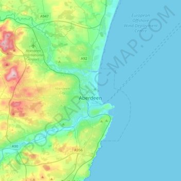
Name: Aberdeen City topographic map, elevation, terrain.
Location: Aberdeen City, Scotland, United Kingdom (57.07619 -2.36094 57.23531 -2.01615)
Average elevation: 46 m
Minimum elevation: 0 m
Maximum elevation: 262 m
Two weather stations collect climate data for the area, Aberdeen/Dyce Airport, and Craibstone. Both are about 4+1⁄2 miles (7 km) to the north west of the city centre, and given that they are in close proximity to each other, exhibit very similar climatic regimes. Dyce tends to have marginally warmer daytime temperatures year round owing to its slightly lower elevation, though it is more susceptible to harsh frosts. The coldest temperature to occur in recent years was −16.8 °C (1.8 °F) during December 2010, while the following winter, Dyce set a new February high temperature station record on 28 February 2012 of 17.2 °C (63.0 °F), and a new March high temperature record of 21.6 °C (70.9 °F) on 25 March 2012.
Other topographic maps
Click on a map to view its topography, its elevation and its terrain.
Johnstone
United Kingdom > Scotland > Renfrewshire
Johnstone, Renfrewshire, Scotland, PA5 8DT, United Kingdom
Average elevation: 65 m
Ayton
United Kingdom > Scotland > Scottish Borders
Ayton, Scottish Borders, Scotland, TD14 5RU, United Kingdom
Average elevation: 75 m
Newton of Kinkell
United Kingdom > Scotland > Highland > Mulbuie
Newton of Kinkell, Mulbuie, Highland, Scotland, IV7 8DQ, United Kingdom
Average elevation: 112 m
Kirkton of Tough
United Kingdom > Scotland > Aberdeenshire
Kirkton of Tough, Aberdeenshire, Scotland, AB33 8ER, United Kingdom
Average elevation: 210 m
Peebles
United Kingdom > Scotland > Scottish Borders
Peebles, Scottish Borders, Scotland, EH45 8SL, United Kingdom
Average elevation: 275 m
Castlehill Reservoir
United Kingdom > Scotland > Perth and Kinross > Glendevon
Castlehill Reservoir, Glendevon, Perth and Kinross, Scotland, United Kingdom
Average elevation: 268 m
Innerleithen
United Kingdom > Scotland > Scottish Borders
Innerleithen, Scottish Borders, Scotland, EH44 6HD, United Kingdom
Average elevation: 292 m
Cumbernauld
United Kingdom > Scotland > North Lanarkshire
Cumbernauld, North Lanarkshire, Scotland, United Kingdom
Average elevation: 113 m
Upper Glendevon Reservoir
United Kingdom > Scotland > Perth and Kinross
Upper Glendevon Reservoir, Backhill, Perth and Kinross, Scotland, United Kingdom
Average elevation: 414 m
Newton
United Kingdom > Scotland > Dumfries and Galloway
Newton, Dumfries and Galloway, Scotland, DG10 9NX, United Kingdom
Average elevation: 117 m
Kirkton
United Kingdom > Scotland > Dumfries and Galloway
Kirkton, Dumfries and Galloway, Scotland, DG1 1WD, United Kingdom
Average elevation: 24 m
Kilmarnock
United Kingdom > Scotland > East Ayrshire
Kilmarnock, East Ayrshire, Scotland, KA1 1HZ, United Kingdom
Average elevation: 56 m
Killiedraught Bay
United Kingdom > Scotland > Eyemouth
Killiedraught Bay, Eyemouth, Scotland, TD14 5EQ, United Kingdom
Average elevation: 23 m
Whitebridge
United Kingdom > Scotland > Highland
Whitebridge, Highland, Scotland, IV2 6UW, United Kingdom
Average elevation: 223 m
Beattock
United Kingdom > Scotland > Dumfries and Galloway
Beattock, Dumfries and Galloway, Scotland, DG10 9RB, United Kingdom
Average elevation: 144 m
Durness
United Kingdom > Scotland > Highland
Durness, Highland, Scotland, IV27 4PR, United Kingdom
Average elevation: 28 m
Eyre
United Kingdom > Scotland > Highland
Eyre, Highland, Scotland, IV51 9XE, United Kingdom
Average elevation: 72 m
Insh
United Kingdom > Scotland > Highland
Insh, Highland, Scotland, PH21 1NT, United Kingdom
Average elevation: 275 m
Isle of Arran
United Kingdom > Scotland > North Ayrshire
Isle of Arran, North Ayrshire, Scotland, United Kingdom
Average elevation: 98 m
Middle Norton
United Kingdom > Scotland > City of Edinburgh > Ratho Station
Middle Norton, Ratho Station, City of Edinburgh, Scotland, EH28 8NA, United Kingdom
Average elevation: 52 m
Bridge of Earn
United Kingdom > Scotland > Perth and Kinross
Bridge of Earn, Perth and Kinross, Scotland, PH2 9PL, United Kingdom
Average elevation: 70 m
Castletown
United Kingdom > Scotland > Highland
Castletown, Highland, Scotland, KW14 8UE, United Kingdom
Average elevation: 25 m
Staffa
United Kingdom > Scotland > Argyll and Bute
Staffa, Argyll and Bute, Scotland, United Kingdom
Average elevation: 0 m
Ashens
United Kingdom > Scotland > Angus
Ashens, Angus, Scotland, DD8 5JT, United Kingdom
Average elevation: 396 m
Crathie
United Kingdom > Scotland > Aberdeenshire
Crathie, Aberdeenshire, Scotland, AB35 5UL, United Kingdom
Average elevation: 359 m
Spin
United Kingdom > Scotland > Western Isles
Spin, Western Isles, Scotland, HS8 5SN, United Kingdom
Average elevation: 241 m
Bo'ness
United Kingdom > Scotland > Falkirk
Bo'ness, Falkirk, Scotland, EH51 9AB, United Kingdom
Average elevation: 29 m
Keith
United Kingdom > Scotland > Moray
Keith, Moray, Scotland, AB55 5FF, United Kingdom
Average elevation: 180 m
West Belt
United Kingdom > Scotland > Aberdeen City
West Belt, Ashwood, Bridge of Don, Aberdeen City, Scotland, United Kingdom
Average elevation: 72 m
Loch Ness
United Kingdom > Scotland > Highland > Dores
Loch Ness, Dores, Highland, Scotland, PH32 4BN, United Kingdom
Average elevation: 340 m
Broadford
United Kingdom > Scotland > Highland
Broadford, Highland, Scotland, IV49 9AD, United Kingdom
Average elevation: 34 m
East Mains
United Kingdom > Scotland > Aberdeenshire > Banchory
East Mains, Banchory, Aberdeenshire, Scotland, AB31 4BG, United Kingdom
Average elevation: 99 m
Dounreay
United Kingdom > Scotland > Caithness
Dounreay, Caithness, Scotland, KW14 7TZ, United Kingdom
Average elevation: 36 m
Balbeggie
United Kingdom > Scotland > Perth and Kinross
Balbeggie, Perth and Kinross, Scotland, PH2 6HA, United Kingdom
Average elevation: 119 m
Reef
United Kingdom > Scotland > Western Isles
Reef, Western Isles, Scotland, HS2 9HU, United Kingdom
Average elevation: 18 m
Ochil Hills
United Kingdom > Scotland > Perth and Kinross > Auchterarder
Ochil Hills, Auchterarder, Perth and Kinross, Scotland, United Kingdom
Average elevation: 235 m
Carmunnock
United Kingdom > Scotland > Glasgow City
Carmunnock, Glasgow City, Scotland, G76 9BX, United Kingdom
Average elevation: 120 m
Coupar Angus
United Kingdom > Scotland > Perth and Kinross
Coupar Angus, Perth and Kinross, Scotland, PH13 9DA, United Kingdom
Average elevation: 70 m
Bearsden
United Kingdom > Scotland > East Dunbartonshire
Bearsden, East Dunbartonshire, Scotland, G61 3RU, United Kingdom
Average elevation: 72 m
Aviemore
United Kingdom > Scotland > Highland
Aviemore, Highland, Scotland, PH22 1RN, United Kingdom
Average elevation: 331 m
City of Edinburgh
City of Edinburgh, Scotland, United Kingdom
Average elevation: 118 m
Glenmore
United Kingdom > Scotland > Highland
Glenmore, Highland, Scotland, PH22 1QY, United Kingdom
Average elevation: 414 m
Armadale
United Kingdom > Scotland > West Lothian
Armadale, West Lothian, Scotland, EH48 3QB, United Kingdom
Average elevation: 166 m
Cumnock
United Kingdom > Scotland > East Ayrshire
Cumnock, East Ayrshire, Scotland, KA18 1AY, United Kingdom
Average elevation: 187 m
Renfrew
United Kingdom > Scotland > Renfrewshire
Renfrew, Renfrewshire, Scotland, PA4 8TU, United Kingdom
Average elevation: 16 m
Ardross
United Kingdom > Scotland > Highland
Ardross, Highland, Scotland, IV17 0YE, United Kingdom
Average elevation: 223 m
Ruddenleys
United Kingdom > Scotland > Scottish Borders
Ruddenleys, Scottish Borders, Scotland, EH46 7BN, United Kingdom
Average elevation: 319 m
St Fillans
United Kingdom > Scotland > Perth and Kinross
St Fillans, Perth and Kinross, Scotland, PH6 2ND, United Kingdom
Average elevation: 292 m
Edinburgh
United Kingdom > Scotland > City of Edinburgh > Edinburgh
Edinburgh, City of Edinburgh, Scotland, EH1 3EG, United Kingdom
Average elevation: 104 m