
Lhasa topographic map
Interactive map
Click on the map to display elevation.
About this map
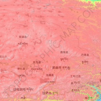
Name: Lhasa topographic map, elevation, terrain.
Location: Lhasa, Tibet, 850000, China (29.24065 89.75281 36.34330 95.16436)
Average elevation: 4,866 m
Minimum elevation: 2,877 m
Maximum elevation: 7,466 m
Lhasa prefecture-level city roughly corresponds to the basin of the Lhasa River, a major tributary of the Yarlung Tsangpo River. Exceptions are the north of Damxung County, which crosses the watershed of the Nyenchen Tanglha Mountains and includes part of the Namtso lake, and Nyêmo County, which covers the basin of the Nimu Maqu River, a direct tributary of the Yarlung Tsangpo. The river basin is separated from the Yarlung Tsangpo valley to the south by the Goikarla Rigyu range. The largest tributary of the Lhasa River, the Reting Tsangpo, originates in the Chenthangula Mountains in Nagqu Prefecture at an elevation of about 5,500 metres (18,000 ft), and flows southwest into Lhasa past Reting Monastery.
Other topographic maps
Click on a map to view its topography, its elevation and its terrain.
Qanag
China > Tibet > Mainling City
Qanag, Mainling City, Nyingchi Prefecture, Tibet, China
Average elevation: 3,790 m
Lhoka
China > Tibet > Tsetang Township
Lhoka, Tsetang Township, Nêdong District, Lhoka, Tibet, China
Average elevation: 4,148 m
Tuiwa
China > Tibet > Nakartse County > Daglung
Tuiwa, Daglung, Nakartse County, Shannan, Tibet, China
Average elevation: 5,039 m
Gelong
China > Tibet > Kangmar County
Gelong, Kangmar County, Shigatse Prefecture, Tibet, China
Average elevation: 4,593 m
Tabia Tsaka
China > Tibet > Drongpa County
Tabia Tsaka, Drongpa County, Shigatse Prefecture, Tibet, China
Average elevation: 4,497 m
Summit Pyramid
China > Tibet > Tingri County > Tashi Dzom
Summit Pyramid, Tashi Dzom, Tingri County, Shigatse, Tibet, China
Average elevation: 7,868 m
Gamba County
China > Tibet > Gamba County
Gamba County, Shigatse, Tibet, China
Average elevation: 4,993 m
宗嘎镇
China > Tibet > Gyirong County
宗嘎镇, Gyirong County, Shigatse, Tibet, China
Average elevation: 4,978 m
Ronxar
China > Tibet > Tingri County > Ronxar
Ronxar, Tingri County, Shigatse, Tibet, China
Average elevation: 5,002 m
Dordon
China > Tibet > Rutog County > Dongru
Dordon, Dongru, Rutog County, Ngari Prefecture, Tibet, China
Average elevation: 5,482 m
Mount Kailash
Mount Kailash, Darchen, Ngari Prefecture, Tibet, China
Average elevation: 5,748 m
Mount Makalu
China > Tibet > Tingri County
Mount Makalu, Tingri County, Shigatse, Tibet, China
Average elevation: 7,484 m