
Neer topographic map
Click on the map to display elevation.
Neer
Neer ligt nabij de Maas, op een hoogte van ongeveer 26 meter. Ten noorden van Neer komt het Afwateringskanaal Meijel-Neer aan de Maas uit in de Maas, en ten zuiden van Neer vloeit de Neerbeek in de Maas, welke de afwatering van een aanzienlijk gebied ten westen van Neer verzorgt.
About this map
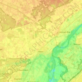
Name: Neer topographic map, elevation, terrain.
Location: Neer, Leudal, Limburg, Nederland (51.23395 5.91933 51.30999 6.01101)
Average elevation: 27 m
Minimum elevation: 8 m
Maximum elevation: 38 m
Other topographic maps
Click on a map to view its topography, its elevation and its terrain.
Maas
Nederland > Limburg > Maastricht > Borgharen
Er is dan ook vaak hoogwater op de Maas. Het hoogste waterpeil van de afgelopen eeuwen bereikte de rivier tijdens de overstroming van januari 1643, waarbij grote verwoestingen werden aangericht en honderden doden te betreuren waren. Door de verbreding en verdieping van de Maas (vanaf 1840) werd het water…
Average elevation: 49 m
Meers
De plaats is gelegen op de oostelijke oever van de Maas die met een bocht om het dorp Meers loopt, opmerkelijk is dat de rivier bij het maken van deze bocht weer een klein stukje in zuidelijke richting stroomt. De hoogte van Meers bedraagt ongeveer 38 meter. Door de aanleg van het Julianakanaal in de jaren…
Average elevation: 44 m
Ubachsberg
Ubachsberg ligt op het Plateau van Ubachsberg op een hoogte van ongeveer 180 meter. Ten noorden van Ubachsberg ligt het natuurgebied de Kunderberg. Ten zuiden van de Kunderberg liggen de Geulkerberg, Putberg en de Keverberg. Tussen de Geulkerberg en de Putberg/Keverberg ligt een dal met daarin de historische…
Average elevation: 164 m
Rothem
Naar Rothem is het Rothem Terras (of Terras van Rothem) genoemd. Dit is een rivierterras dat gevormd is door de Maas tijdens het Midden Pleistoceen. Het Rothem Terras is een oude alluviale vlakte waarvan de bovenkant van de rivierafzettingen ter hoogte van Maastricht op ongeveer 81,5 meter boven NAP ligt. De…
Average elevation: 62 m
Vaesrade
Vaesrade ligt tegen de helling van het Plateau van Doenrade, op de rechteroever van de Geleenbeek op een hoogte van ongeveer 80 meter. Men vindt hier het Kathagerbroek, nabij de buurtschap Kathagen. Enkele holle wegen voeren omhoog naar het plateau, waar ten noorden van Vaesrade een hoogste punt van 112,8…
Average elevation: 87 m
Brachterbeek
Brachterbeek ligt op het middenterras van de Maas, nabij het laagterras, op een hoogte van ongeveer 27 meter, en het dorp is aan twee zijden ingeklemd door het Clauscentrale-complex met koeltorens, opslagtanks, haven en transformatorstation, van waar tal van hoogspanningsleidingen uitwaaieren. In het westen…
Average elevation: 26 m
Neerbeek
Neerbeek ligt op het Plateau van Graetheide op een hoogte van ongeveer 73 meter, naar het noorden, westen en zuidwesten ingeklemd tussen bebouwing en chemiebedrijven. Het wordt vanouds doorstroomd door de Keutelbeek, maar deze is geheel overkluisd. Naar het zuidoosten toe begint het open gebied en ligt de…
Average elevation: 78 m
Laar
Laar is gelegen in het landelijk gebied ten noordwesten van Weert op een hoogte van ongeveer 32 meter. Door de aanleg van autowegen, bedrijventerreinen en -in het eerste kwart van de 21e eeuw- ook woonwijken komt de stad steeds dichterbij. Ten zuiden van Laar wordt de nieuwe woonwijk Laarveld gerealiseerd. Het…
Average elevation: 33 m
Budschop
Budschop ligt op zandgrond, op een hoogte van ongeveer 32 meter. Het wordt in het westen door de Zuid-Willemsvaart van de kern Nederweert en in het zuidoosten door de Noordervaart van de kern Nederweert-Eind gescheiden. Tussen Budschop en de buurtschap Hulsen ligt een schutsluis.
Average elevation: 33 m
Kunrade
Kunrade ligt op een hoogte van ongeveer 100 meter, op de grens tussen het Plateau van Ubachsberg en het Bekken van Heerlen//Geleenbeekdal. In het noorden is Kunrade vastgebouwd aan Voerendaal, in het zuiden loopt een autosnelweg, de A79. Aan de oostelijke zijde vormt de A76 de grens tussen het landelijke…
Average elevation: 114 m
Nijswiller
Nijswiller ligt in het Selzerbeekdal, op een hoogte van ongeveer 120 meter. In het noordoosten ligt het Plateau van Bocholtz met het Kolmonderbosch en het Platte Bosch. In het zuidwesten ligt het Plateau van Vaals. Door het dorp stroomt de Selzerbeek.
Average elevation: 152 m
Tungelroy
Tungelroy is gelegen op een hoogte van ongeveer 31 meter op zandgrond. Een belangrijk deel van het grondgebied wordt door de landbouw ingenomen. Ten zuiden van Tungelroy stroomt de Tungelroyse Beek die een bodemsanering en een herinrichting heeft ondergaan (afgerond in 2007). Een belangrijk natuurgebied is de…
Average elevation: 32 m
Holset
Het dorp ligt in het Selzerbeekdal op een lage heuvelrug die zich uitstrekt vanaf het ten zuiden van het dorp gelegen Vijlenerbos tot aan Lemiers, waarbij de heuvelrug geleidelijk aan steeds verder afloopt. Deze heuvelrug scheidt de ten westen van het dorp gelegen Hermansbeek van de ten oosten gelegen…
Average elevation: 208 m
Rijckholt
Rijckholt ligt in het Maasdal op een hoogte van ongeveer 52 meter. De omgeving wordt beheerst door boomgaarden en landbouw. Ten oosten van Rijckholt ligt de helling naar het Plateau van Margraten, met op deze helling het Savelsbos, een belangrijk natuurgebied. Ten westen van Rijckholt ligt het tracé van de…
Average elevation: 80 m
Wahlwiller
Wahlwiller ligt in het Selzerbeekdal op een hoogte van ongeveer 120 meter, tussen het Plateau van Vaals en het Plateau van Bocholtz. Vooral in noordelijke richting is er een steile helling, naar de Kruisberg met enkele holle wegen. langs de noordrand van het dorp stroomt de Selzerbeek.
Average elevation: 135 m
Slek
Slek is hoogstwaarschijnlijk een verbastering van het woord slenk. In de geologie staat het woord slenk voor een laagte in het landschap. Een horst staat voor een hoogte in het landschap. Aan de overzijde van de Provinciale weg N276 ligt hoeve "de Horst", een rond het jaar 1400 gebouwd Gelders leenhof. De…
Average elevation: 32 m
Roermond
Nederland > Limburg > Roermond
Roermond werd in 1130 Ruregemunde genoemd. Het eerste woorddeel verwijst naar de rivier Roer, die genoemd zou zijn naar een Keltisch-Germaanse watergodin "Rura". Het tweede woorddeel lijkt te verwijzen naar de "monding" van de Roer, maar dit is minder waarschijnlijk aangezien de Roer en de Maas tot ±1340 aan…
Average elevation: 39 m
Schinnen
Nederland > Limburg > Schinnen
Schinnen ligt in het dal van de Geleenbeek, waar die samenkomt met het dal van de Kakkert. Het dorp bevindt zich tegen de helling van een uitloper van het Plateau van Doenrade en de kerk ligt op ongeveer 75 meter hoogte. Deze uitloper staat bekend als de Moutheuvel. Enkele wegen vormen hier de oude toegang…
Average elevation: 92 m
Blerick
Blerick ligt op de westoever van de Maas, op een hoogte van ongeveer 18 meter. Door een spoorbrug en een verkeersbrug is Blerick met Venlo verbonden. Ten noorden van Blerick vindt men een industriehaven en grootschalige bedrijventerreinen, waartussen de buurtschap Ubroek ligt geklemd. In het westen ligt…
Average elevation: 23 m
Benzenrade
Ter hoogte van Benzenrade ligt in de ondergrond de Benzenraderbreuk. Ten zuiden van Benzenrade ligt de Putberg en ten zuidwesten begint het Droogdal de Dael. Ten zuiden van Benzenrade ligt de Benzenradergroeve.
Average elevation: 154 m
Houthem
Nederland > Limburg > Valkenburg
Houthem ligt in de vallei van de Geul, aan de rechteroever, op een hoogte van ongeveer 60 meter. In de omgeving van Houthem liggen diverse hellingbossen (waaronder op de noordhelling van het Geuldal het Kloosterbosch) en in het Geuldal het natuurontwikkelingsgebied Ingendael.
Average elevation: 105 m
Maastricht
Nederland > Limburg > Maastricht
Maastricht ligt in het zuiden van Nederland. De stad ligt aan de voet van de Sint-Pietersberg, tussen het Plateau van Margraten, het Plateau van Caestert en de Haspengouw, op de plaats waar de rivier de Jeker in de Maas uitmondt. Het centrum van de stad ligt op een hoogte van ca. 50 meter boven NAP. De…
Average elevation: 101 m
Cadier en Keer
Nederland > Limburg > Cadier en Keer > Cadier en Keer
De naam zou volgens een andere verklaring betrekking kunnen hebben op het het Keltische woord kadeir, dat 'hoogte' of 'heuvel' betekent (zie etymologie bij Cauberg).
Average elevation: 114 m
Sint Geertruid
Nederland > Limburg > Sint Geertruid > Sint Geertruid
Sint Geertruid ligt op ongeveer 138 m hoogte, op het Plateau van Margraten. Ten westen en zuiden van Sint Geertruid, daar waar dit plateau afdaalt in het Maasdal bevindt zich een hellingbos, het Savelsbos. Dit is niet alleen natuurhistorisch van groot belang, maar in het bos zijn bovendien de Henkeput en een…
Average elevation: 125 m
Henkeput
Nederland > Limburg > Sint Geertruid > Rijckholt
In 1961 werd er onderzoek verricht door H. Schroevers-Kommandeur en S. de Jager van het Zoölogisch Museum (Amsterdam) en het RijksInstituut voor Veldbiologisch Onderzoek ten behoeve van het Natuurbehoud (RIVON te Zeist, deze organisatie is in 1969 opgegaan in het Rijksinstituut voor Natuurbeheer, een van de…
Average elevation: 102 m
Ulestraten
Nederland > Limburg > Ulestraten > Ulestraten
Ulestraten ligt aan de rand van het Centraal Plateau op een hoogte van ongeveer 115 meter. In het westen vindt men het vliegveld en bijbehorend Bedrijventerrein. De Sint-Catharinastraat, die de hoofdstraat van het dorp vormt, ligt relatief laag, en hierlangs loopt de Vliekerwateroplossing die er ook een bron…
Average elevation: 112 m
Tegelen
Nederland > Limburg > Tegelen > Tegelen
Tegelen ligt aan de Maas op een hoogte van ongeveer 18 meter. Naar het oosten toe, op het hoogterras, loopt de hoogte op tot bijna 50 meter. Hier bevinden zich de kleigroeven, en er ligt het natuurgebied Holtmühle, dat in Duitsland aansluit op het natuurgebied Ravensheide en het Brachterwald. Meer naar het…
Average elevation: 24 m
Schimmert
Nederland > Limburg > Schimmert > Schimmert
Schimmert is gelegen op het Centraal Plateau op een hoogte van ongeveer 130 meter. Dit is een landbouwgebied doorsneden door een aantal oude wegen en paden. Ten zuiden van Schimmert, voornamelijk in de gemeente Valkenburg aan de Geul, ligt het Ravensbosch, een hellingbos en natuurgebied.
Average elevation: 125 m