
Leslie Dam topographic map
Interactive map
Click on the map to display elevation.
About this map
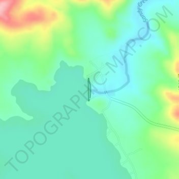
Name: Leslie Dam topographic map, elevation, terrain.
Location: Leslie Dam, Warwick, Queensland, 4370, Australia (-28.21876 151.91811 -28.21534 151.91847)
Average elevation: 483 m
Minimum elevation: 442 m
Maximum elevation: 597 m
Queensland trails, hiking, mountain biking, running and outdoor activities
Other topographic maps
Click on a map to view its topography, its elevation and its terrain.
Warwick
Australia > Queensland > Warwick
Warwick has a humid subtropical climate (Köppen Cfa) with hot summers and cool to cold winters. It is slightly cooler and less humid than the proximate southeast Queensland coast due to its inland, elevation location. Frost is present in winter. The climate bears similarities with Richmond, an inland suburb…
Average elevation: 517 m