
Make a donation
Gear up for your next adventure:
As an Amazon Associate, this site earns from qualifying purchases at no extra cost to you.
Deer Lake topographic map
Click on the map to display elevation.
Make a donation
Gear up for your next adventure:
As an Amazon Associate, this site earns from qualifying purchases at no extra cost to you.
About this map
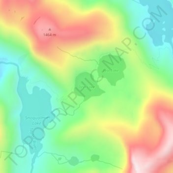
Name: Deer Lake topographic map, elevation, terrain.
Location: Deer Lake, King County, Washington, United States (47.56856 -121.40374 47.57318 -121.39643)
Average elevation: 1,153 m
Minimum elevation: 900 m
Maximum elevation: 1,517 m
Make a donation
Gear up for your next adventure:
As an Amazon Associate, this site earns from qualifying purchases at no extra cost to you.
Other topographic maps
Click on a map to view its topography, its elevation and its terrain.
Seattle
United States > Washington > King County
Seattle features a diverse topography characterized by its unique geographical setting between Puget Sound and Lake Washington. The city is situated on an isthmus, which contributes to its dramatic landscape, featuring rolling hills and steep slopes that rise abruptly from the waterfront. The average elevation…
Average elevation: 40 m
Seattle
United States > Washington > King County
The city itself is hilly, though not uniformly so. Like Rome, the city is said to lie on seven hills; the lists vary but typically include Capitol Hill, First Hill, West Seattle, Beacon Hill, Queen Anne, Magnolia, and the former Denny Hill. The Wallingford, Delridge, Mount Baker, Seward Park, Washington Park,…
Average elevation: 40 m
Make a donation
Gear up for your next adventure:
As an Amazon Associate, this site earns from qualifying purchases at no extra cost to you.
Snoqualmie
United States > Washington > King County
Snoqualmie is located at 47°31′59″N 121°50′40″W / 47.53306°N 121.84444°W / 47.53306; -121.84444 (47.532934, -121.844341), at an elevation of 410 feet (120 m) above MSL.
Average elevation: 213 m
Stevens Pass
United States > Washington > King County
Stevens Pass (elevation 4,061 ft (1,238 m)) is a mountain pass through the Cascade Mountains located at the border of King County and Chelan County in Washington, United States. U.S. Route 2 travels over the pass, reaching a maximum elevation of 4,061 feet (1,238 m). The Pacific Crest Trail crosses the highway…
Average elevation: 1,387 m
Make a donation
Gear up for your next adventure:
As an Amazon Associate, this site earns from qualifying purchases at no extra cost to you.
Vashon Island
United States > Washington > King County > Vashon
Vashon Island features a diverse topography characterized by rolling hills, lush forests, and scenic waterfronts. The island rises gently from sea level to elevations reaching around 500 feet (approximately 150 meters) at its highest point, providing sweeping views of Puget Sound and the surrounding mountains.…
Average elevation: 46 m
Redmond
United States > Washington > King County
Redmond features a diverse topography characterized by its gently rolling hills and lush landscapes. The city lies at an average elevation of approximately 250 feet (76 meters) above sea level, with elevations varying between 15 feet (5 meters) to about 500 feet (152 meters) across the region. This varied…
Average elevation: 72 m
Make a donation
Gear up for your next adventure:
As an Amazon Associate, this site earns from qualifying purchases at no extra cost to you.
Make a donation
Gear up for your next adventure:
As an Amazon Associate, this site earns from qualifying purchases at no extra cost to you.
Seattle
United States > Washington > King County
The city is hilly in some places. Like Rome, the city is said to lie on seven hills; the lists vary but typically include Capitol Hill, First Hill, West Seattle, Beacon Hill, Queen Anne, Magnolia, and the former Denny Hill. The Wallingford, Delridge, Mount Baker, Seward Park, Washington Park, Broadmoor,…
Average elevation: 40 m
Bothell
United States > Washington > King County
Other events are hosted by community organizations, such as the annual Bothell block party and brewfest sponsored by University of Washington Bothell and the local chamber of commerce. The annual "Sustainamania" has been held in Bothell since 2012 to promote sustainable living, conservation, and education. A…
Average elevation: 68 m
Make a donation
Gear up for your next adventure:
As an Amazon Associate, this site earns from qualifying purchases at no extra cost to you.
Make a donation
Gear up for your next adventure:
As an Amazon Associate, this site earns from qualifying purchases at no extra cost to you.
Bothell
United States > Washington > King County
Other events are hosted by community organizations, such as the annual Bothell block party and brewfest sponsored by University of Washington Bothell and the local chamber of commerce. The annual "Sustainamania" has been held in Bothell since 2012 to promote sustainable living, conservation, and education. A…
Average elevation: 68 m
Make a donation
Gear up for your next adventure:
As an Amazon Associate, this site earns from qualifying purchases at no extra cost to you.
Mercer Island
United States > Washington > King County
The peak elevation in the city is about 338 feet (103 m), near the center of the island.
Average elevation: 38 m
Make a donation
Gear up for your next adventure:
As an Amazon Associate, this site earns from qualifying purchases at no extra cost to you.
Kirkland
United States > Washington > King County
According to the United States Census Bureau, the city has a total area of 17.83 square miles (46.18 km2), of which 17.818 square miles (46.15 km2) are land and 0.012 square miles (0.03 km2) are water. The elevation varies from 14 to 500 feet (150 m) above sea level.
Average elevation: 58 m
Make a donation
Gear up for your next adventure:
As an Amazon Associate, this site earns from qualifying purchases at no extra cost to you.
Make a donation
Gear up for your next adventure:
As an Amazon Associate, this site earns from qualifying purchases at no extra cost to you.
Des Moines
United States > Washington > King County
Des Moines is one of the few points along this shoreline where the topography facilitates access to the water, and a recreational marina operated by the city, with moorage, boat launching and pier fishing facilities, is located there. Forested Saltwater State Park on a steep ravine between the Zenith and…
Average elevation: 41 m
Make a donation
Gear up for your next adventure:
As an Amazon Associate, this site earns from qualifying purchases at no extra cost to you.
Make a donation
Gear up for your next adventure:
As an Amazon Associate, this site earns from qualifying purchases at no extra cost to you.
Make a donation
Gear up for your next adventure:
As an Amazon Associate, this site earns from qualifying purchases at no extra cost to you.
Union Hill-Novelty Hill
United States > Washington > King County > Union Hill-Novelty Hill
Average elevation: 96 m
Make a donation
Gear up for your next adventure:
As an Amazon Associate, this site earns from qualifying purchases at no extra cost to you.
Newcastle
United States > Washington > King County
The area was an unincorporated area within King County until it incorporated as a city on September 30, 1994. Currently the city is a suburban community. Based on Newcastle's location north of Renton, south of Bellevue, and across Lake Washington from Seattle, these are the communities in which most of the…
Average elevation: 162 m
Fall City
United States > Washington > King County
The Fall City Airport is a small private airport community located 2 miles (3 km) east of the community at latitude 47-33-34.366 N and longitude 121-51-49.413 W, at an elevation of 140 feet (43 m) above sea level. The airport is owned by the Fall City Airport Association. It has no air traffic control tower.[8]
Average elevation: 48 m
Make a donation
Gear up for your next adventure:
As an Amazon Associate, this site earns from qualifying purchases at no extra cost to you.
Preston
United States > Washington > King County
Preston is a historic mill town on the northeast edge of the large Tiger Mountain State Forest, along Interstate 90. Preston, elevation 430 ft (130 m), is located within commuting distance of Seattle and Bellevue.
Average elevation: 270 m
Make a donation
Gear up for your next adventure:
As an Amazon Associate, this site earns from qualifying purchases at no extra cost to you.
Mount Si
United States > Washington > King County
The peak can be accessed by two trails. The Old Mount Si trail is accessed by the Little Si parking lot and the Boulder Garden Loop. It is 0.6 miles (0.97 km) shorter, 270 feet (82 m) steeper in elevation gain, and less crowded than the main trail. The Mount Si trail is accessed by the Mount Si parking lot.
Average elevation: 793 m
Make a donation
Gear up for your next adventure:
As an Amazon Associate, this site earns from qualifying purchases at no extra cost to you.
Make a donation
Gear up for your next adventure:
As an Amazon Associate, this site earns from qualifying purchases at no extra cost to you.
Hot Springs
United States > Washington > King County
Hot Springs is located east of Enumclaw and just west of Lester, along the Green River and BNSF Railway line. Its elevation is 1512 feet (460m) above sea level.
Average elevation: 588 m
Make a donation
Gear up for your next adventure:
As an Amazon Associate, this site earns from qualifying purchases at no extra cost to you.
Stampede Pass
United States > Washington > King County
Stampede Pass (elevation 3,672 feet (1,119 m)) is a mountain pass in the northwest United States, through the Cascade Range in Washington. Southeast of Seattle and east of Tacoma, its importance to transportation lies almost entirely with railroading, as no paved roads cross it. It is approximately twelve…
Average elevation: 1,135 m
Make a donation
Gear up for your next adventure:
As an Amazon Associate, this site earns from qualifying purchases at no extra cost to you.
Make a donation
Gear up for your next adventure:
As an Amazon Associate, this site earns from qualifying purchases at no extra cost to you.
Make a donation
Gear up for your next adventure:
As an Amazon Associate, this site earns from qualifying purchases at no extra cost to you.
Mount Index
United States > Washington > King County
Mount Index is a peak in the central part of the Cascade Range of Washington state. It lies just south of the Skykomish River and U.S. Route 2, at the western edge of the Cascades. Despite its low elevation relative to peaks higher in the Cascades, it is a famous and dramatic landmark due to its topographic…
Average elevation: 1,178 m
Make a donation
Gear up for your next adventure:
As an Amazon Associate, this site earns from qualifying purchases at no extra cost to you.
Seattle
United States > Washington > King County
The city is hilly in some places. Like Rome, the city is said to lie on seven hills; the lists vary but typically include Capitol Hill, First Hill, West Seattle, Beacon Hill, Queen Anne, Magnolia, and the former Denny Hill. The Wallingford, Delridge, Mount Baker, Seward Park, Washington Park, Broadmoor,…
Average elevation: 40 m
Mercer Island
United States > Washington > King County
The peak elevation in the city is about 335 feet (102 m), near the center of the island.
Average elevation: 38 m
Make a donation
Gear up for your next adventure:
As an Amazon Associate, this site earns from qualifying purchases at no extra cost to you.
Seattle
United States > Washington > King County
The city is hilly in some places. Like Rome, the city is said to lie on seven hills; the lists vary but typically include Capitol Hill, First Hill, West Seattle, Beacon Hill, Queen Anne, Magnolia, and the former Denny Hill. The Wallingford, Delridge, Mount Baker, Seward Park, Washington Park, Broadmoor,…
Average elevation: 40 m
Make a donation
Gear up for your next adventure:
As an Amazon Associate, this site earns from qualifying purchases at no extra cost to you.