
Town of Alice Springs topographic map
Interactive map
Click on the map to display elevation.
About this map
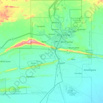
Name: Town of Alice Springs topographic map, elevation, terrain.
Location: Town of Alice Springs, Northern Territory, Australia (-23.83150 133.72598 -23.63051 133.94046)
Average elevation: 600 m
Minimum elevation: 524 m
Maximum elevation: 935 m
Other topographic maps
Click on a map to view its topography, its elevation and its terrain.
Sydney
Phillip had been given no instructions for urban development, but in July 1788 submitted a plan for the new town at Sydney Cove. It included a wide central avenue, a permanent Government House, law courts, hospital and other public buildings, but no provision for warehouses, shops, or other commercial…
Average elevation: 53 m
Adelaide
Australia > South Australia > Adelaide
Adelaide is north of the Fleurieu Peninsula, on the Adelaide Plains between the Gulf St Vincent and the low-lying Mount Lofty Ranges. The city stretches 20 km (12 mi) from the coast to the foothills, and 90 km (56 mi) from Gawler at its northern extent to Sellicks Beach in the south. According to the Regional…
Average elevation: 148 m
Victoria
Victoria contains many topographically, geologically and climatically diverse areas, ranging from the wet, temperate climate of Gippsland in the southeast to the snow-covered Victorian alpine areas which rise to almost 2,000 m (6,600 ft), with Mount Bogong the highest peak at 1,986 m (6,516 ft). There are…
Average elevation: 179 m
New South Wales
The climate in the southern half of the state is generally warm to hot in summer and cool in the winter. The seasons are more defined in the southern half of the state, especially as one moves inland towards South West Slopes, Central West and the Riverina region. The climate in the northeast region of the…
Average elevation: 154 m
Tasmania
The most mountainous region is the Central Highlands area, which covers most of the central western parts of the state. The Midlands located in the central east, is fairly flat, and is predominantly used for agriculture, although farming activity is scattered throughout the state. Tasmania's tallest mountain…
Average elevation: 220 m
Western Australia
Because the only mountain-building since then has been of the Stirling Range with the rifting from Antarctica, the land is extremely eroded and ancient, with no part of the state above 1,245 metres (4,085 ft) AHD (at Mount Meharry in the Hamersley Range of the Pilbara region). Most of the state is a low…
Average elevation: 194 m
Canberra
The area chosen for the capital had been inhabited by Indigenous Australians for up to 21,000 years, with the principal group being the Ngunnawal people. European settlement commenced in the first half of the 19th century, as evidenced by surviving landmarks such as St John's Anglican Church and Blundells…
Average elevation: 638 m
Melbourne
Melbourne is also prone to isolated convective showers forming when a cold pool crosses the state, especially if there is considerable daytime heating. These showers are often heavy and can include hail, squalls, and significant drops in temperature, but they often pass through very quickly with a rapid…
Average elevation: 185 m
Ballarat
Ballarat has a moderate oceanic climate (Köppen climate classification Cfb) with four distinct seasons. Its elevation, ranging between 400 and 630 metres (1,310 and 2,070 feet) above sea level, causes its mean monthly temperatures to tend to be on average 3 to 5 °C (5 to 9 °F) below those of Melbourne,…
Average elevation: 470 m
Toowoomba
The city occupies the edge of the range and the low ridges behind it. Two valleys run north from the southern boundary, each arising from springs either side of Middle Ridge near Spring Street at an altitude of around 680 m. These waterways, East Creek and West Creek, flow together just north of the CBD to…
Average elevation: 458 m
Mount Kosciuszko
Mount Kosciuszko is the highest summit in mainland Australia. Until 1977 it was possible to drive from Charlotte Pass to within a few metres of the summit, but in 1977 the road was closed to public motor vehicle access due to environmental concerns. The road is open from Charlotte Pass for walkers and cyclists…
Average elevation: 2,035 m
Goulburn
Owing to its elevation, Goulburn has an oceanic climate (Cfb) with warm summers and cool winters; with a high diurnal range. Its climate is variable much of the year, though generally dry with maximum temperatures ranging from 11.8 °C (53.2 °F) in July to 28.3 °C (82.9 °F) in January. Rainfall is…
Average elevation: 666 m
Adelaide
Australia > South Australia > Adelaide City Council
South Australia was officially established as a British Province in England in February 1836. The first governor proclaimed the commencement of colonial government in South Australia on 28 December 1836, near The Old Gum Tree in what is now the suburb of Glenelg North. The event is commemorated in South…
Average elevation: 146 m
Dandenong Ranges National Park - Ferntree Gully
Australia > Victoria > Montrose
The topography consists of a series of ridges dissected by deeply cut streams. Sheltered gullies in the south of the range are home to temperate rain forest, fern gullies and Mountain Ash forest Eucalyptus regnans, whereas the drier ridges and exposed northern slopes are covered by dry sclerophyll forest of…
Average elevation: 345 m
Cairns
South of Smithfield and inland from the Northern Beaches along the edge of the Barron River flood plain are the suburbs of Caravonica, Kamerunga, Freshwater, and Stratford. This area is sometimes referred to as Freshwater Valley, though it is actually the lower part of Redlynch Valley; further up the valley…
Average elevation: 176 m
Mount Barker
Australia > South Australia > Mount Barker District Council
Mount Barker is located on the plains surrounding the Mount Barker Summit, about 2 km west of the mountain itself, at 35°04′S 138°51′E / 35.067°S 138.850°E / -35.067; 138.850. Mount Barker is south east of Mount Lofty and Adelaide. It is to the north of The Coorong, and the west of Murray…
Average elevation: 368 m