Geolocate

Salto topographic map

Interactive map

Click on the map to display elevation.

About this map

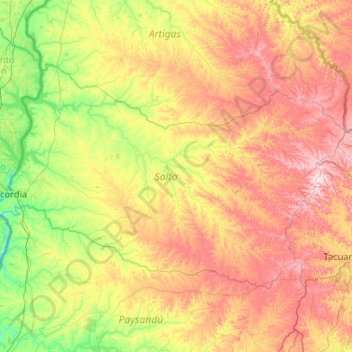
Name: Salto topographic map, elevation, terrain.

Location: Salto, Uruguay (-31.87129 -58.08336 -30.74154 -56.00981)

Average elevation: 135 m

Minimum elevation: -1 m

Maximum elevation: 415 m

Other topographic maps

Click on a map to view its topography, its elevation and its terrain.

Constitución

Uruguay > Salto

Constitución, Salto, 50002, Uruguay

Average elevation: 40 m

Salto

Uruguay > Salto

Salto, 50000, Uruguay

Average elevation: 34 m

Toro Negro

Uruguay > Salto

Toro Negro, Salto, Uruguay

Average elevation: 223 m

Las Flores

Uruguay > Salto > Las Flores

Las Flores, Salto, 50000, Uruguay

Average elevation: 105 m

Termas del Daymán

Uruguay > Salto

Termas del Daymán, Salto, 50000, Uruguay

Average elevation: 21 m