
Make a donation
Gear up for your next adventure:
As an Amazon Associate, this site earns from qualifying purchases at no extra cost to you.
Puebla topographic map
Click on the map to display elevation.
Make a donation
Gear up for your next adventure:
As an Amazon Associate, this site earns from qualifying purchases at no extra cost to you.
Puebla
Most of the mountains of Puebla belong to the Sierra Madre Oriental and the Trans-Mexican Volcanic Belt. The first is locally called the Sierra Norte del Puebla, entering the state from the northwest and then breaks up into the smaller chains of Sierra de Zacapoaxtla, Sierra de Huauchinango, Sierra de Teziutlán, Sierra de Tetela de Ocampo, Sierra de Chignahuapan and Sierra de Zacatlán, although these names may vary among localities. Some of the highest elevations include Apulco, Chichat, Chignahuapan, Soltepec and Tlatlaquitepec. The highest elevations are the volcanoes Pico de Orizaba or Citlaltepetl (5,747masl), Popocatépetl (5,452masl), Iztaccíhuatl (5,286masl) and Malinche (4,461masl) which are found on the state's borders with Veracruz, Mexico State and Tlaxcala respectively. In the south of the state, the major elevations are the Sierra de Atenahuacán, Zapotitlán, Lomerio al Suroeste and the Sierra de Tehuacán. Dividing much of the state from Veracruz is a small chain of mountains called the Sierra Madre del Golfo.
Make a donation
Gear up for your next adventure:
As an Amazon Associate, this site earns from qualifying purchases at no extra cost to you.
About this map
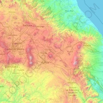
Name: Puebla topographic map, elevation, terrain.
Location: Puebla, Mexico (17.86091 -99.07049 20.83963 -96.72462)
Average elevation: 1,532 m
Minimum elevation: 0 m
Maximum elevation: 5,520 m
Make a donation
Gear up for your next adventure:
As an Amazon Associate, this site earns from qualifying purchases at no extra cost to you.
Other topographic maps
Click on a map to view its topography, its elevation and its terrain.
Mexico City
Mexico > Mexico City > Mexico City
Mexico City is located in the Valley of Mexico, sometimes called the Basin of Mexico. This valley is located in the Trans-Mexican Volcanic Belt in the high plateaus of south-central Mexico. It has a minimum altitude of 2,200 meters (7,200 feet) above sea level and is surrounded by mountains and volcanoes that…
Average elevation: 2,321 m
Santiago Tianguistenco
The municipality lies in the Trans-Mexican Volcanic Belt in the sub-province of the Lakes and Volcanoes of Anahuac. 35% of the municipality is mountainous, 30% is arable and the rest is developed. The topography of the municipality varies due to its size. The eastern portions are highest as they are in the…
Average elevation: 2,645 m
Make a donation
Gear up for your next adventure:
As an Amazon Associate, this site earns from qualifying purchases at no extra cost to you.
Nevado de Toluca
Mexico > State of Mexico > Toluca
Most of the other sites are found on the crater's walls and peaks. One of the sites is called Xicotepec which is at the top of a rocky dome known as the Cerro de Ombligo (Spanish for "the navel"). Principally green obsidian blades and multicolored ceramic has been found here. On the north side of the crater is…
Average elevation: 4,280 m
Pachuca
Mexico > Hidalgo > Pachuca de Soto
Pachuca has a semi-arid climate (Köppen climate classification BSk). The climate is cool with high rainfall and occasional hail during the summer months and dry conditions during the winter. The coldest month is January, with an average high of 20 °C (68 °F) and an average low of 3 °C (37 °F). Winter…
Average elevation: 2,459 m
Make a donation
Gear up for your next adventure:
As an Amazon Associate, this site earns from qualifying purchases at no extra cost to you.
Toluca
Mexico > State of Mexico > Toluca
The Lerma River flows from Lake Almoloya del Río through the center of the municipality towards the west, flowing into Lake Chapala. From this point westward the river takes the name of Río Grande de Santiago. And it goes from this lake to the Pacific Ocean in the state of Nayarit. The river is about 1,180…
Average elevation: 2,729 m
Amacuzac
San Gabriel las Palmas has 2,955 residents. Its principal economic activity is agriculture. It is 44 kilometres (27 mi) from Cuernavaca and 4.3 kilometres (2.7 mi) from the municipal seat. There is one preschool, two elementary schools (grades 1-6), and a middle school (grades 7-9). It is located at an…
Average elevation: 954 m
Make a donation
Gear up for your next adventure:
As an Amazon Associate, this site earns from qualifying purchases at no extra cost to you.
Tequila
Tequila is one of the 124 municipalities of Jalisco, located just west of the center of the state. Its territory extends for 1689.11km2, with elevations that vary between 700 and 2,900 meters above sea level. The municipality borders with the main metropolitan region of Guadalajara to the east (Zapopan), and…
Average elevation: 1,267 m
Make a donation
Gear up for your next adventure:
As an Amazon Associate, this site earns from qualifying purchases at no extra cost to you.
La Desviación (Colonia Vicente Guerrero)
Mexico > Veracruz > Úrsulo Galván > Zempoala
Average elevation: 16 m
Tuxtla Gutiérrez
Mexico > Chiapas > Tuxtla Gutiérrez
On the edge of the city is the El Zapotal Ecological Reserve, best known as the home of the Zoológico Miguel Alvarez del Toro Zoo, often referred to as the ZooMAT. The zoo covers 100 hectares and was founded by Miguel Alvarez del Toro in 1942. He was also the director for over fifty years. ZooMAT is…
Average elevation: 817 m
Make a donation
Gear up for your next adventure:
As an Amazon Associate, this site earns from qualifying purchases at no extra cost to you.
San Cristóbal Zapotitlán
Mexico > Jalisco > Jocotepec > San Cristóbal Zapotitlán
Average elevation: 1,552 m
Chihuahua
Mexico > Chihuahua > Municipio de Chihuahua
Chihuahua lies on the western side of the Chihuahuan Desert ecoregion and as such has a semiarid climate (Köppen climate classification BSh). However, it is not as hot as most of the lower elevated portions of the desert to the east owing to an altitude of almost 1,500 metres (4,900 feet) above sea level.
Average elevation: 1,555 m
Make a donation
Gear up for your next adventure:
As an Amazon Associate, this site earns from qualifying purchases at no extra cost to you.
Parque Nacional Molino de Flores Netzahualcoyotl
Mexico > State of Mexico > Texcoco > Xocotlán
Average elevation: 2,313 m
Make a donation
Gear up for your next adventure:
As an Amazon Associate, this site earns from qualifying purchases at no extra cost to you.
Hermosillo
Mexico > Sonora > Hermosillo
The Cerro de la Campana mountain is one of the symbols of Hermosillo. Its summit is 350 metres (1,150 ft) above the valley floor and contains a lookout called El Caracol, which was inaugurated in 1909. There are two theories as to the origin of the mountain's name. One states that it is from a peculiar…
Average elevation: 248 m
Make a donation
Gear up for your next adventure:
As an Amazon Associate, this site earns from qualifying purchases at no extra cost to you.
San Francisco del Rincón
Mexico > Guanajuato > San Francisco del Rincón
The settlement was founded as San Francisco del Tule on January 21, 1607 by a group of families of the Purépecha and Hñähñu (Otomi) ethnicities. It was declared a villa (town) on September 6, 1865 and a city on March 27, 1867. It is located at 21°01′22″N 101°51′36″W / 21.02278°N…
Average elevation: 1,767 m
Make a donation
Gear up for your next adventure:
As an Amazon Associate, this site earns from qualifying purchases at no extra cost to you.