
Morogoro Region topographic map
Interactive map
Click on the map to display elevation.
About this map
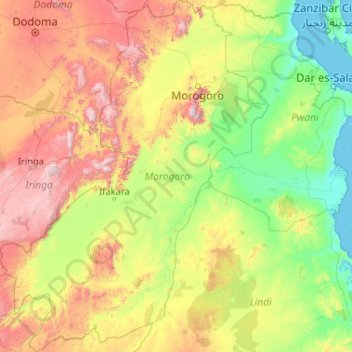
Name: Morogoro Region topographic map, elevation, terrain.
Location: Morogoro Region, Coastal Zone, Tanzania (-9.92346 35.32406 -5.80227 38.51660)
Average elevation: 539 m
Minimum elevation: 0 m
Maximum elevation: 2,560 m
The Morogoro region has a total size of 73,039 square kilometers, which is split between land (70,967 square kilometers, or 97.2 percent of the total area), and water (2,073 km2 or 2.8 percent). As of 2012, Ulanga District is the largest district,Malinyi DC comes in second with 17.0 percent of the region's total land area, followed by Morogoro DC with 16.1 percent. Kilosa District comes in first with 18.6 percent. Morogoro Municipal was the district with the smallest land size (531 km2 or 10.7%), followed by Gairo DC with (1,851 km2 or 2.5 percent). Different scenarios exist in Kilosa DC, Malinyi DC, Ifakara TC, Ulanga DC, Morogoro MC, and Gairo DC, with all of their respective territories being completely covered by land. While Mvomero DC (1,882 km2) has the most water area in the area. At Mlimba DC, there is the smallest water area (70 km2). According to topographical and ecological zones, the region's soils differ.
Other topographic maps
Click on a map to view its topography, its elevation and its terrain.
Makunduchi
Tanzania > Zanzibar South & Central
Makunduchi, Kusini, Zanzibar South & Central, Zanzibar, 72103, Tanzania
Average elevation: 17 m
Isapula
Isapula, Makete, Njombe Region, Southern Highlands Zone, Tanzania
Average elevation: 2,229 m
Dodoma
Dodoma, Dodoma City, Dodoma Region, Central Zone, Tanzania
Average elevation: 1,144 m
Iwafi
Iwafi, Njombe, Njombe Region, Southern Highlands Zone, Tanzania
Average elevation: 1,600 m
Lupembe
Lupembe, Njombe, Njombe Region, Southern Highlands Zone, Tanzania
Average elevation: 1,574 m
Madudu
Madudu, Kilosa, Morogoro Region, Coastal Zone, Tanzania
Average elevation: 450 m
Maleuts
Maleuts, Makete, Njombe Region, Southern Highlands Zone, Tanzania
Average elevation: 2,204 m
Kilimanjaro National Park
Tanzania > Kilimanjaro > Moshi
Kilimanjaro National Park, Barranco Wall, Moshi, Hai, Kilimanjaro, Northern Zone, Tanzania
Average elevation: 2,137 m
Sumbawanga
Sumbawanga, Sumbawanga Urban, Rukwa Region, Southern Highlands Zone, Tanzania
Average elevation: 1,844 m
Moshi
Tanzania > Kilimanjaro > Moshi
Moshi, Hai, Kilimanjaro, Northern Zone, 25107, Tanzania
Average elevation: 1,109 m
Waranga
Waranga, Hanang, Manyara Region, Northern Zone, Tanzania
Average elevation: 1,448 m
Songwe Region
Songwe Region, Southern Highlands Zone, Tanzania
Average elevation: 1,326 m
Kitongoji cha Makanisani
Tanzania > Simiyu > Lamadi > Kitongoji cha Makanisani
Kitongoji cha Makanisani, Lamadi, Busega, Simiyu, Lake Zone, Tanzania
Average elevation: 1,140 m
Serengeti National Park
Serengeti National Park, Ikoma, Serengeti, Mara Region, Lake Zone, Tanzania
Average elevation: 1,524 m
Oysterbay
Oysterbay, Msasani, Dar es Salaam, Coastal Zone, Tanzania
Average elevation: 6 m
Kinondoni
Kinondoni, Dar es Salaam, Coastal Zone, 14110, Tanzania
Average elevation: 12 m
Kilombero
Tanzania > Zanzibar North > Kilombero
Kilombero, Zanzibar North, Zanzibar, Tanzania
Average elevation: 54 m
Kidayi 'A'
Tanzania > Morogoro > Kidayi 'A'
Kidayi 'A', Kilosa, Morogoro, Coastal Zone, Tanzania
Average elevation: 659 m
Uhuru Peak
Uhuru Peak, Rombo, Kilimanjaro, Northern Zone, Tanzania
Average elevation: 5,494 m
Tarangire National Park
Tarangire National Park, Ridge Road, Babati, Manyara, Northern Zone, Tanzania
Average elevation: 1,252 m