
Rockingham County topographic map
Interactive map
Click on the map to display elevation.
About this map
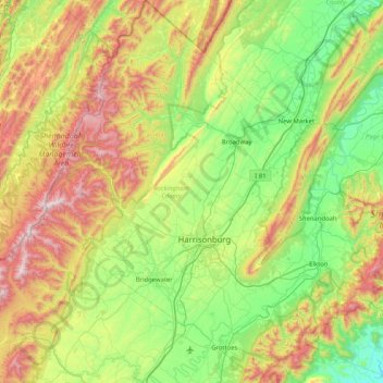
Name: Rockingham County topographic map, elevation, terrain.
Location: Rockingham County, Virginia, United States (38.20818 -79.22141 38.85010 -78.48574)
Average elevation: 525 m
Minimum elevation: 138 m
Maximum elevation: 1,320 m
Other topographic maps
Click on a map to view its topography, its elevation and its terrain.
Deep Creek
United States > Virginia > Accomack County
It lies at an elevation of 3 feet.
Average elevation: 1 m