
Palm Island topographic map
Interactive map
Click on the map to display elevation.
About this map
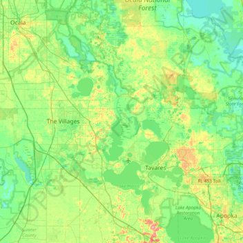
Name: Palm Island topographic map, elevation, terrain.
Location: Palm Island, Lake County, Florida, United States (28.60554 -82.14814 29.24554 -81.50814)
Average elevation: 24 m
Minimum elevation: 1 m
Maximum elevation: 94 m
Other topographic maps
Click on a map to view its topography, its elevation and its terrain.
Pinellas County
Elevation in the county ranges from mean sea level to its highest natural point of 110 feet (34 m) near the intersection of SR 580 and Countryside Blvd. in Clearwater. Due to its small size and high population, by the early 21st century Pinellas County has been mostly built out, with very little developable…
Average elevation: 4 m
Treasure Island
United States > Florida > Pinellas County
With an elevation of only three feet, the Great Gale of 1848 carved out John's Pass on the island's north end and split off two smaller islands, called the Isle of Palms and Isle of Capri.
Average elevation: 2 m
Wesley Chapel
United States > Florida > Pasco County
According to the United States Census Bureau, the CDP has a total area of 6.1 square miles (16 km2), of which 6.1 square miles (16 km2) is land and 0.04 square miles (0.10 km2) (0.49%) is water. The elevation is about 100 feet (30 m), combined with an inland location, creates more temperature variation in the…
Average elevation: 19 m
Carrollwood
United States > Florida > Hillsborough County > Tampa
Carrollwood is located at 28.1 degrees north, 82.5 degrees west (28.0523, -82.4858). The elevation for the community is 39 feet (12 m) above sea level.
Average elevation: 16 m
Vero Beach
United States > Florida > Indian River County
Like much of Florida, Vero Beach is mostly flat, stretching from the beach and running inland. The average elevation of the city is 23 feet above sea level.
Average elevation: 6 m
Orlando
United States > Florida > Orange County
According to the Köppen climate classification, Orlando has a humid subtropical climate (Cfa) like much of the deep Southern United States. The two basic seasons in Orlando are a hot and rainy season, lasting from May until late October (roughly coinciding with the Atlantic hurricane season), and a warm and…
Average elevation: 30 m
Apollo Beach
United States > Florida > Hillsborough County
The history of Apollo Beach started in 1923 on land owned by the Dickman family, then used annually for farming and grazing pasture. Much of the land was mangrove and low-elevation and was considered uninhabitable.
Average elevation: 6 m
West Palm Beach
United States > Florida > Palm Beach County
Northwood Hills Historic District: On August 4, 2003, the City Commission designated the Northwood Hills neighborhood as the 13th Historic District in the City of West Palm Beach. Northwood Hills comprises the area from 29th Street on the South to 39th Court on the North. The east side of Windsor is the…
Average elevation: 4 m
Bradenton
United States > Florida > Manatee County
Bradenton was affected by World War II like many other cities in Florida and the United States. During the war, Manatee County had its own Civil Defense battalion in it with two subunits existing in Bradenton and another for nearby Manatee. A recreational center was opened in March 1942 at a building on the…
Average elevation: 5 m
Saint Leo
United States > Florida > Pasco County
St. Leo contains rolling hills with elevations from 100 ft to 180 ft.
Average elevation: 46 m
Pensacola
United States > Florida > Escambia County
The land is sloped up northward from Pensacola Bay, with most of the city at an elevation above that which a potential hurricane storm surge could affect.
Average elevation: 21 m
Tampa
United States > Florida > Hillsborough County
Tampa is characterized by a predominantly flat topography, with an average elevation around 16 to 49 feet (5 to 15 meters) above sea level. The terrain is marked by low-lying areas and gentle slopes, with the highest points in the vicinity reaching approximately 62 feet (19 meters). This landscape is…
Average elevation: 11 m
Dade City
United States > Florida > Pasco County
Dade City contains gently rolling topography with elevations from 60 ft to 100 ft.
Average elevation: 33 m
Oldsmar
United States > Florida > Pinellas County
In 1921, a hurricane hit Tampa Bay. Because Oldsmar sits on a plateau with an elevation never rising over 20 feet (6.1 m) above sea level, it was devastated by the storm. Large trees were uprooted and floodwater reached levels 14 feet (4.3 m) above normal. Some of the homes that survived the storm were moved,…
Average elevation: 6 m
Marco Island
United States > Florida > Collier County
Marco Island is the largest barrier island within Southwest Florida's Ten Thousand Islands area extending southerly to Cape Sable. Parts of the island have some scenic, high elevations relative to the generally flat south Florida landscape. The island has a tropical climate; specifically a tropical wet and dry…
Average elevation: 2 m
Pasco County
A portion of Eastern Pasco County contains rolling topography with elevations from 100 to 160 ft (30 to 49 m), along with San Antonio and St. Leo.
Average elevation: 18 m