
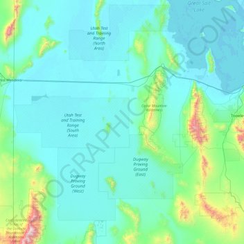
Tooele County topographic map
Interactive map
Click on the map to display elevation.
About this map
Name: Tooele County topographic map, elevation, terrain.
Location: Tooele County, Utah, United States (39.90335 -114.04838 41.07684 -112.14425)
Average elevation: 1,463 m
Minimum elevation: 1,279 m
Maximum elevation: 3,633 m
Tooele County lies on the west side of Utah. Its west border abuts the east border of the state of Nevada. Its northeast border abuts the Great Salt Lake. Three significant mountain ranges run north-south through the county. Its east boundary line is delineated by the crestline of the Oquirrh Mountains, which separate the Tooele Valley from the Salt Lake Valley. The Stansbury Mountains parallel the Oquirrhs in the eastern part of the county, and the Cedar Mountains also run parallel to the other two through the east-central part of the county. There are also isolated prominences across the county, especially at its SW corner. The county terrain is largely arid and unused for agriculture unless irrigation water is available. The county generally slopes to the north. Its highest elevation is Deseret Peak in the Stansburys, at 11,031' (3362m) ASL. The county has a total area of 7,286 square miles (18,870 km2), of which 6,941 square miles (17,980 km2) is land and 345 square miles (890 km2) (4.7%) is water.
Other topographic maps
Click on a map to view its topography, its elevation and its terrain.
Ophir
United States > Utah > Tooele County
Ophir, Tooele County, Utah, United States
Average elevation: 2,232 m
Sandy
United States > Utah > Salt Lake County
Sandy, Salt Lake County, Utah, United States
Average elevation: 1,376 m
drainage
United States > Utah > Salt Lake County > West Jordan
drainage, West Jordan, Salt Lake County, Utah, United States
Average elevation: 1,389 m
Bayview Heights
United States > Utah > Davis County > Farmington
Bayview Heights, Farmington, Davis County, Utah, 84025, United States
Average elevation: 1,457 m
Virgin
United States > Utah > Washington County
Virgin, Washington County, Utah, United States
Average elevation: 1,251 m
Axtell
United States > Utah > Sanpete County
Axtell, Sanpete County, Utah, 84621, United States
Average elevation: 1,572 m
Park City
United States > Utah > Summit County
Park City, Summit County, Utah, United States
Average elevation: 2,290 m
Kimball Junction
United States > Utah > Summit County
Kimball Junction, Summit County, Utah, 84098, United States
Average elevation: 2,004 m
Bear River
United States > Utah > Rich County
Bear River, Rich County, Utah, 84086, United States
Average elevation: 1,924 m
Salt Lake City
United States > Utah > Salt Lake County > Salt Lake City
Salt Lake City, Salt Lake County, Utah, 84139, United States
Average elevation: 1,625 m
Solitude
United States > Utah > Salt Lake County > Solitude
Solitude, Salt Lake County, Utah, United States
Average elevation: 2,706 m
Paria Canyon
Paria Canyon, Kane County, Utah, United States
Average elevation: 1,581 m
Colorado Plateau
United States > Utah > San Juan County
Colorado Plateau, San Juan County, Utah, United States
Average elevation: 1,512 m
Aquarius Plateau
United States > Utah > Garfield County
Aquarius Plateau, Garfield County, Utah, United States
Average elevation: 3,024 m
Jensen
United States > Utah > Uintah County > Jensen
Jensen, Uintah County, Utah, 84035, United States
Average elevation: 1,470 m
Moab
United States > Utah > Grand County
Moab, Grand County, Utah, 84532, United States
Average elevation: 1,357 m
Midvale
United States > Utah > Midvale
Midvale, Salt Lake County, Utah, 84047, United States
Average elevation: 1,335 m
Farmington Heights
United States > Utah > Farmington > Farmington Heights
Farmington Heights, Farmington, Davis County, Utah, 84025, United States
Average elevation: 1,511 m
Paria River
Paria River, Kane County, Utah, 84718, United States
Average elevation: 1,802 m
West Jordan
United States > Utah > West Jordan
West Jordan, Salt Lake County, Utah, United States
Average elevation: 1,372 m
Salt Lake City
United States > Utah > Salt Lake County
Salt Lake City, Salt Lake County, Utah, United States
Average elevation: 1,592 m
Zion National Park
United States > Utah > Washington County
Zion National Park, Washington County, Utah, United States
Average elevation: 1,877 m
Mount Nebo
United States > Utah > Juab County
Mount Nebo, Juab County, Utah, United States
Average elevation: 3,115 m
South Jordan
United States > Utah > South Jordan
South Jordan, Salt Lake County, Utah, United States
Average elevation: 1,383 m
Provo
United States > Utah > Utah County
Provo, Utah County, Utah, United States
Average elevation: 1,728 m
Saint George
United States > Utah > Washington County
Saint George, Washington County, Utah, United States
Average elevation: 929 m
Mount Magog
United States > Utah > Cache County
Mount Magog, Cache County, Utah, United States
Average elevation: 2,710 m