
Jomsom topographic map
Interactive map
Click on the map to display elevation.
About this map
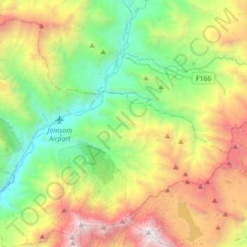
Name: Jomsom topographic map, elevation, terrain.
Location: Jomsom, Gharapjhong, मुस्ताङ, Gandaki, Népal (28.68667 83.64637 28.86745 83.89084)
Average elevation: 4,121 m
Minimum elevation: 2,531 m
Maximum elevation: 7,112 m
Jomosom est une ville du Népal, située à 2 850 m d’altitude dans le district de Mustang. C'est une importante ville de garnison dont la position stratégique privilégiée sur la Kâlî Gandakî permettait jadis de contrôler tout passage entre les basses vallées du Népal et le plateau tibétain. Son nom est d'ailleurs une déformation d'un mot tibétain « dzong sum » qui signifie « les trois forteresses ».
Other topographic maps
Click on a map to view its topography, its elevation and its terrain.
Lamanthang
Lamanthang, लोमान्थाङ, मुस्ताङ, Gandaki, Népal
Average elevation: 4,899 m
Ekle Bhatti
Népal > मुस्ताङ > Kagbeni > Ekle Bhatti
Ekle Bhatti, Kagbeni, Barhagaun Muktikhsetra, मुस्ताङ, Gandaki Pradesh, Népal
Average elevation: 3,031 m