
Ghansa topographic map
Interactive map
Click on the map to display elevation.
About this map
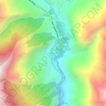
Name: Ghansa topographic map, elevation, terrain.
Location: Ghansa, Lete, Thasang, मुस्ताङ, Gandaki, Népal (28.57946 83.62261 28.61946 83.66261)
Average elevation: 2,567 m
Minimum elevation: 1,827 m
Maximum elevation: 3,621 m
Other topographic maps
Click on a map to view its topography, its elevation and its terrain.
Lamanthang
Lamanthang, लोमान्थाङ, मुस्ताङ, Gandaki, Népal
Average elevation: 4,899 m
Ekle Bhatti
Népal > मुस्ताङ > Kagbeni > Ekle Bhatti
Ekle Bhatti, Kagbeni, Barhagaun Muktikhsetra, मुस्ताङ, Gandaki Pradesh, Népal
Average elevation: 3,031 m