Dodge County topographic map
Click on the map to display elevation.
Dodge County
The Heart of Georgia Regional Airport is located three miles east of Eastman off of State Route 46. Elevation 304'. Runway 02/20 is 6,506'x100'and has a precision instrument landing system. The airport is owned by the Heart of Georgia Regional Airport Authority and is home to the Middle Georgia State College Georgia Aviation campus. Middle Georgia State College operates the Federal Aviation Administration's #1 ranked student control tower in the United States. Other businesses at the airport include aircraft manufacturing, aircraft metal finishing, and general metal fabrication. The airport's fixed-base operator is located in the terminal building midfield. The terminal building is named after W. S. Stuckey Sr., founder of Stuckey's Candy Company (now Standard Candy) an aviation pioneer who is from Eastman.
About this map
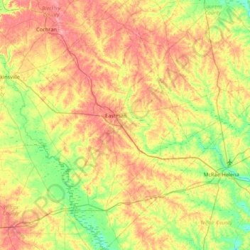
Name: Dodge County topographic map, elevation, terrain.
Location: Dodge County, Georgia, United States (31.90071 -83.37412 32.45243 -82.85804)
Average elevation: 84 m
Minimum elevation: 40 m
Maximum elevation: 141 m
Other topographic maps
Click on a map to view its topography, its elevation and its terrain.



Rivet Hill
United States > Georgia > Chattahoochee County > Chattahoochee County
Average elevation: 113 m

Atlanta
United States > Georgia > Fulton County
Atlanta occupies a high, rolling part of the Georgia Piedmont, a physiographic region described as a landscape of low hills and narrow valleys between the Blue Ridge Mountains and the Upper Coastal Plain. Around downtown and Fulton County, the terrain is gently dissected rather than flat, with broad urban…
Average elevation: 285 m
Mount Vernon
United States > Georgia > Richmond County > Augusta > Mount Vernon
Average elevation: 77 m