
Clallam County topographic map
Interactive map
Click on the map to display elevation.
About this map
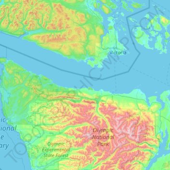
Name: Clallam County topographic map, elevation, terrain.
Location: Clallam County, Washington, United States (47.86688 -124.83609 48.49344 -122.89716)
Average elevation: 335 m
Minimum elevation: -2 m
Maximum elevation: 2,383 m
Other topographic maps
Click on a map to view its topography, its elevation and its terrain.
Everett
United States > Washington > Snohomish County
Everett, Snohomish County, Washington, United States
Average elevation: 66 m
Lynnwood
United States > Washington > Snohomish County
Lynnwood, Snohomish County, Washington, 98037, United States
Average elevation: 121 m
Puyallup
United States > Washington > Pierce County
Puyallup, Pierce County, Washington, United States
Average elevation: 66 m
Kelso
United States > Washington > Cowlitz County
Kelso, Cowlitz County, Washington, 98626, United States
Average elevation: 52 m
Kenmore
United States > Washington > King County
Kenmore, King County, Washington, 98028, United States
Average elevation: 59 m
Whidbey Island
United States > Washington > Island County
Whidbey Island, Island County, Washington, United States
Average elevation: 45 m
Sugarloaf Peak
United States > Washington > Chelan County
Sugarloaf Peak, Chelan County, Washington, United States
Average elevation: 1,550 m
Mount Vernon
United States > Washington > Skagit County
Mount Vernon, Skagit County, Washington, 98273, United States
Average elevation: 37 m
South Cove Park
United States > Washington > King County > Issaquah
South Cove Park, Issaquah, King County, Washington, United States
Average elevation: 40 m
Raymond
United States > Washington > Pacific County
Raymond, Pacific County, Washington, 98577, United States
Average elevation: 67 m
Little Blue Lake
United States > Washington > Skamania County
Little Blue Lake, Skamania County, Washington, United States
Average elevation: 158 m
Quilcene
United States > Washington > Jefferson County > Quilcene
Quilcene, Jefferson County, Washington, United States
Average elevation: 268 m
Spokane
United States > Washington > Spokane County
Spokane, Spokane County, Washington, United States
Average elevation: 655 m
DuPont
United States > Washington > Pierce County
DuPont, Pierce County, Washington, 98327, United States
Average elevation: 65 m
Dungeness Spit
United States > Washington > Clallam County > Old Town
Dungeness Spit, Old Town, Clallam County, Washington, United States
Average elevation: 3 m
Maple Falls
United States > Washington > Whatcom County
Maple Falls, Whatcom County, Washington, United States
Average elevation: 442 m
Ellensburg
United States > Washington > Kittitas County
Ellensburg, Kittitas County, Washington, 98926, United States
Average elevation: 480 m
Covington
United States > Washington > King County
Covington, King County, Washington, 98042, United States
Average elevation: 137 m
Interlaken Park
United States > Washington > King County > Seattle
Interlaken Park, Capitol Hill, Seattle, King County, Washington, United States
Average elevation: 48 m
Sunshine Beach
United States > Washington > Pierce County
Sunshine Beach, Pierce County, Washington, 98394, United States
Average elevation: 47 m
Granite Falls
United States > Washington > Snohomish County
Granite Falls, Snohomish County, Washington, United States
Average elevation: 120 m
Graham
United States > Washington > Pierce County
Graham, Pierce County, Washington, 09339, United States
Average elevation: 205 m
Central Park
United States > Washington > Grays Harbor County
Central Park, Grays Harbor County, Washington, United States
Average elevation: 46 m
Orting
United States > Washington > Pierce County
Orting, Pierce County, Washington, 98360, United States
Average elevation: 112 m
Wilson
United States > Washington > Lewis County
Wilson, Lewis County, Washington, United States
Average elevation: 358 m
Lava Dome
United States > Washington > Skamania County
Lava Dome, Skamania County, Washington, United States
Average elevation: 2,109 m
Riverton
United States > Washington > King County > Tukwila
Riverton, Tukwila, King County, Washington, 98168, United States
Average elevation: 77 m
Ferndale
United States > Washington > Whatcom County
Ferndale, Whatcom County, Washington, United States
Average elevation: 29 m
Cake Rock
United States > Washington > Clallam County
Cake Rock, Clallam County, Washington, United States
Average elevation: 0 m
Pend Orielle River
United States > Washington > Pend Oreille County
Pend Orielle River, Pend Oreille County, Washington, 83822, United States
Average elevation: 1,060 m
Porter
United States > Washington > Grays Harbor County
Porter, Grays Harbor County, Washington, 98559, United States
Average elevation: 49 m
Soap Lake
United States > Washington > Grant County
Soap Lake, Grant County, Washington, 98851, United States
Average elevation: 352 m
Skull Rock
United States > Washington > San Juan County
Skull Rock, San Juan County, Washington, 98243, United States
Average elevation: 21 m
Jones Island
United States > Washington > San Juan County
Jones Island, San Juan County, Washington, United States
Average elevation: 6 m
Discovery Park
United States > Washington > Pierce County > Bonney Lake
Discovery Park, Bonney Lake, Pierce County, Washington, 98391, United States
Average elevation: 195 m
Ramapo
United States > Washington > Clallam County
Ramapo, Clallam County, Washington, United States
Average elevation: 114 m
Harbert
United States > Washington > Walla Walla County
Harbert, Walla Walla County, Washington, United States
Average elevation: 411 m
Mill Creek
United States > Washington > Snohomish County
Mill Creek, Snohomish County, Washington, United States
Average elevation: 130 m
Deer Valley
United States > Washington > Pend Oreille County
Deer Valley, Pend Oreille County, Washington, United States
Average elevation: 724 m
Brookdale
United States > Washington > Pierce County
Brookdale, Pierce County, Washington, 98445, United States
Average elevation: 128 m
Martin
United States > Washington > Kittitas County
Martin, Kittitas County, Washington, United States
Average elevation: 893 m
Richland
United States > Washington > Benton County
Richland, Benton County, Washington, United States
Average elevation: 160 m
Bellevue
United States > Washington > King County
Bellevue, King County, Washington, United States
Average elevation: 66 m
North Bend
United States > Washington > King County
North Bend, King County, Washington, United States
Average elevation: 160 m
Skagit River
United States > Washington > Whatcom County
Skagit River, Whatcom County, Washington, United States
Average elevation: 1,391 m
Kloke Peak (Hayden Peak)
United States > Washington > Whatcom County
Kloke Peak (Hayden Peak), Whatcom County, Washington, United States
Average elevation: 1,544 m
Myrtle Edwards Park
United States > Washington > King County > Seattle
Myrtle Edwards Park, Uptown, Belltown, Seattle, King County, Washington, United States
Average elevation: 22 m
Bothell
United States > Washington > King County
Bothell, King County, Washington, United States
Average elevation: 68 m
Disappointment
United States > Washington > Okanogan County
Disappointment, Okanogan County, Washington, United States
Average elevation: 1,980 m
Mukilteo
United States > Washington > Snohomish County
Mukilteo, Snohomish County, Washington, 98275, United States
Average elevation: 89 m