
Summit County topographic map
Interactive map
Click on the map to display elevation.
About this map
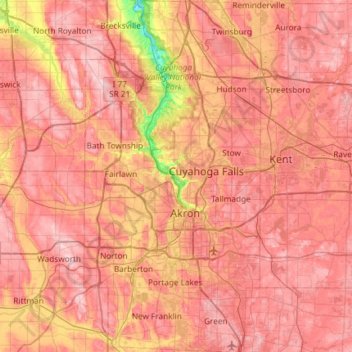
Name: Summit County topographic map, elevation, terrain.
Location: Summit County, Ohio, United States (40.90650 -81.68850 41.35113 -81.39168)
Average elevation: 327 m
Minimum elevation: 187 m
Maximum elevation: 405 m
Summit County is an urban county in the U.S. state of Ohio. As of the 2010 census, the population was 541,781 making it the fourth-most populous county in Ohio. Its county seat is Akron. The county was formed on March 3, 1840, from portions of Medina, Portage and Stark Counties. It was named "Summit County" because the highest elevation on the Ohio and Erie Canal is located in the county.
Other topographic maps
Click on a map to view its topography, its elevation and its terrain.
Chagrin Falls
United States > Ohio > Cuyahoga County
Chagrin Falls, Cuyahoga County, Ohio, United States
Average elevation: 305 m
Cincinnati
United States > Ohio > Hamilton County
Cincinnati, Hamilton County, Ohio, United States
Average elevation: 222 m
Greenfield
United States > Ohio > Highland County
Greenfield, Highland County, Ohio, United States
Average elevation: 276 m
Eastlake
United States > Ohio > Lake County
Eastlake, Lake County, Ohio, 44095, United States
Average elevation: 185 m
Richfield
United States > Ohio > Summit County
Richfield, Summit County, Ohio, 44286, United States
Average elevation: 342 m
Rittman
United States > Ohio > Wayne County
Rittman, Wayne County, Ohio, United States
Average elevation: 312 m
Birdtown
United States > Ohio > Cuyahoga County > Lakewood
Birdtown, Lakewood, Cuyahoga County, Ohio, 44111, United States
Average elevation: 217 m
Symmes Township Park
United States > Ohio > Hamilton County > Loveland
Symmes Township Park, Loveland, Symmes Township, Hamilton County, Ohio, United States
Average elevation: 226 m
Sanctuary Village
United States > Ohio > Franklin County > Columbus
Sanctuary Village, Columbus, Sharon, Franklin County, Ohio, United States
Average elevation: 282 m
Struthers
United States > Ohio > Mahoning County
Struthers, Mahoning County, Ohio, 44471, United States
Average elevation: 302 m
Amberley Village
United States > Ohio > Hamilton County
Amberley Village, Hamilton County, Ohio, United States
Average elevation: 226 m
Newton Falls
United States > Ohio > Trumbull County
Newton Falls, Trumbull County, Ohio, United States
Average elevation: 283 m
Urbana
United States > Ohio > Champaign County
Urbana, Champaign County, Ohio, 43078, United States
Average elevation: 327 m
Huntsville
United States > Ohio > Butler County
Huntsville, Liberty Township, Butler County, Ohio, United States
Average elevation: 251 m
Akron
United States > Ohio > Summit County
Akron, Summit County, Ohio, United States
Average elevation: 315 m
Forest Park
United States > Ohio > Hamilton County
Forest Park, Hamilton County, Ohio, United States
Average elevation: 234 m
Mount Gilead
United States > Ohio > Morrow County
Mount Gilead, Gilead Township, Morrow County, Ohio, 43338, United States
Average elevation: 346 m
Peninsula
United States > Ohio > Summit County
Peninsula, Summit County, Ohio, United States
Average elevation: 259 m
Lockington
United States > Ohio > Shelby County
Lockington, Shelby County, Ohio, United States
Average elevation: 283 m
Stow
United States > Ohio > Summit County
Stow, Summit County, Ohio, 44224, United States
Average elevation: 325 m
Amelia
United States > Ohio > Clermont County
Amelia, Batavia Township, Clermont County, Ohio, 45102, United States
Average elevation: 265 m
Thornville
United States > Ohio > Perry County > Thornville
Thornville, Perry County, Ohio, United States
Average elevation: 301 m
Mason
United States > Ohio > Warren County > Mason
Mason, Warren County, Ohio, 45040, United States
Average elevation: 248 m
Hanging Rock
United States > Ohio > Lawrence County
Hanging Rock, Lawrence County, Ohio, United States
Average elevation: 186 m
Columbus
United States > Ohio > Franklin County > Columbus
Columbus, Franklin County, Ohio, 43216, United States
Average elevation: 255 m
Tinkers Creek
United States > Ohio > Cuyahoga County > Bedford
Tinkers Creek, Bedford, Cuyahoga County, Ohio, 44146, United States
Average elevation: 295 m
Mansfield
United States > Ohio > Richland County
Mansfield, Richland County, Ohio, United States
Average elevation: 387 m
Hillcrest
United States > Ohio > Warren County > Hillcrest
Hillcrest, Warren County, Ohio, 31600, United States
Average elevation: 219 m
Youngstown
United States > Ohio > Mahoning County > Youngstown
Youngstown, Mahoning County, Ohio, United States
Average elevation: 307 m
Fayetteville
United States > Ohio > Brown County > Fayetteville
Fayetteville, Brown County, Ohio, United States
Average elevation: 286 m
Bellbrook
United States > Ohio > Greene County
Bellbrook, Greene County, Ohio, 45305, United States
Average elevation: 262 m
Warren
United States > Ohio > Trumbull County > Warren
Warren, Trumbull County, Ohio, 44483, United States
Average elevation: 296 m
Montgomery Heights
United States > Ohio > Hamilton County > Montgomery > Montgomery Heights
Montgomery Heights, Montgomery, Hamilton County, Ohio, 45242-5324, United States
Average elevation: 241 m
Chesterhill
United States > Ohio > Morgan County > Chesterhill
Chesterhill, Morgan County, Ohio, United States
Average elevation: 277 m
Middletown
United States > Ohio > Butler County > Middletown
Middletown, Butler County, Ohio, United States
Average elevation: 216 m
Parma
United States > Ohio > Cuyahoga County > Parma
Parma, Cuyahoga County, Ohio, United States
Average elevation: 282 m
Willoughby
United States > Ohio > Lake County
Willoughby, Lake County, Ohio, 44094, United States
Average elevation: 199 m
St. Clairsville
United States > Ohio > Belmont County > St. Clairsville
St. Clairsville, Belmont County, Ohio, 43950, United States
Average elevation: 355 m
Mercer County
United States > Ohio > Mercer County
Mercer County, Ohio, United States
Average elevation: 271 m
Mulga
United States > Ohio > Jackson County > Mulga
Mulga, Jackson County, Ohio, United States
Average elevation: 246 m
Carrick Hill
Carrick Hill, Hocking County, Ohio, 43158, United States
Average elevation: 273 m