
Bedford County topographic map
Interactive map
Click on the map to display elevation.
About this map
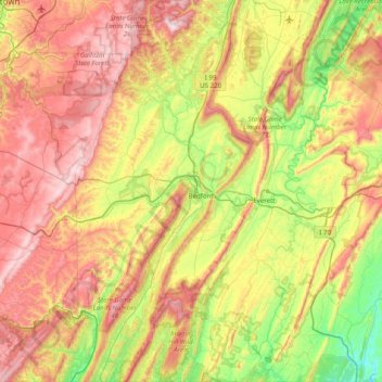
Name: Bedford County topographic map, elevation, terrain.
Location: Bedford County, Pennsylvania, United States (39.72258 -78.80828 40.32703 -78.13472)
Average elevation: 491 m
Minimum elevation: 135 m
Maximum elevation: 956 m
Other topographic maps
Click on a map to view its topography, its elevation and its terrain.
Elephant
United States > Pennsylvania > Bucks County > Bedminster Township
Elephant, Bedminster Township, Bucks County, Pennsylvania, United States
Average elevation: 139 m
Eden Township
United States > Pennsylvania > Lancaster County
Eden Township, Lancaster County, Pennsylvania, United States
Average elevation: 194 m
Armstrong Township
United States > Pennsylvania > Lycoming County
Armstrong Township, Lycoming County, Pennsylvania, 17702, United States
Average elevation: 293 m
Charleroi
United States > Pennsylvania > Washington County
Charleroi, Washington County, Pennsylvania, United States
Average elevation: 283 m
Pine Grove Township
United States > Pennsylvania > Schuylkill County
Pine Grove Township, Schuylkill County, Pennsylvania, 17963, United States
Average elevation: 262 m
Hubbard Mountain
United States > Pennsylvania > Lackawanna County > Scott Township
Hubbard Mountain, Scott Township, Lackawanna County, Pennsylvania, 18452, United States
Average elevation: 503 m
Edenburg
United States > Pennsylvania > Berks County > Windsor Township
Edenburg, Windsor Township, Berks County, Pennsylvania, 19526, United States
Average elevation: 184 m
Keating Township
United States > Pennsylvania > McKean County
Keating Township, McKean County, Pennsylvania, United States
Average elevation: 589 m
New Britain Township
United States > Pennsylvania > Bucks County
New Britain Township, Bucks County, Pennsylvania, United States
Average elevation: 124 m
Glen Lyon
United States > Pennsylvania > Luzerne County > Newport Township
Glen Lyon, Newport Township, Luzerne County, Pennsylvania, 18617, United States
Average elevation: 266 m
Derry Township
United States > Pennsylvania > Montour County
Derry Township, Montour County, Pennsylvania, United States
Average elevation: 190 m
Hammersley
United States > Pennsylvania > Potter County > Wharton Township
Hammersley, Wharton Township, Potter County, Pennsylvania, United States
Average elevation: 515 m
Clearfield County
Clearfield County, Pennsylvania, United States
Average elevation: 513 m
North Middleton Township
United States > Pennsylvania > Cumberland County
North Middleton Township, Cumberland County, Pennsylvania, United States
Average elevation: 172 m
Saw Creek
United States > Pennsylvania > Pike County > Lehman Township
Saw Creek, Lehman Township, Pike County, Pennsylvania, 18314, United States
Average elevation: 276 m
Mercer County
Mercer County, Pennsylvania, United States
Average elevation: 362 m
Morgan
United States > Pennsylvania > Delaware County > Aston Township
Morgan, Aston Township, Delaware County, Pennsylvania, 19015, United States
Average elevation: 44 m
Fairview
United States > Pennsylvania > Butler County
Fairview, Butler County, Pennsylvania, United States
Average elevation: 412 m
Herndon
United States > Pennsylvania > Northumberland County
Herndon, Northumberland County, Pennsylvania, United States
Average elevation: 156 m
New Florence
United States > Pennsylvania > Westmoreland County
New Florence, Westmoreland County, Pennsylvania, United States
Average elevation: 346 m
Beach Lake
United States > Pennsylvania > Wayne County
Beach Lake, Berlin Township, Wayne County, Pennsylvania, United States
Average elevation: 393 m
Mill Run
United States > Pennsylvania > Blair County > Altoona > Allegheny Furnace
Mill Run, Allegheny Furnace, Altoona, Blair County, Pennsylvania, 16603, United States
Average elevation: 349 m
Horsham
United States > Pennsylvania > Montgomery County > Horsham Township
Horsham, Horsham Township, Montgomery County, Pennsylvania, 19044, United States
Average elevation: 89 m
Morgantown
United States > Pennsylvania > Berks County > Caernarvon Township
Morgantown, Caernarvon Township, Berks County, Pennsylvania, 19543, United States
Average elevation: 189 m
Pittsburgh
United States > Pennsylvania > Allegheny County
Pittsburgh, Allegheny County, Pennsylvania, United States
Average elevation: 303 m
Haas
United States > Pennsylvania > Schuylkill County > Eldred Township
Haas, Eldred Township, Schuylkill County, Pennsylvania, 17964, United States
Average elevation: 320 m
Philadelphia
Philadelphia, Pennsylvania, 19140, United States
Average elevation: 68 m
Cambra
United States > Pennsylvania > Luzerne County > Huntington Township
Cambra, Huntington Township, Luzerne County, Pennsylvania, 18622, United States
Average elevation: 311 m
Susquehanna County
Susquehanna County, Pennsylvania, United States
Average elevation: 422 m
Sullivan County
Sullivan County, Pennsylvania, United States
Average elevation: 491 m
Allentown
United States > Pennsylvania > Lehigh County
Allentown, Lehigh County, Pennsylvania, United States
Average elevation: 129 m
Cambria County
Cambria County, Pennsylvania, United States
Average elevation: 554 m
Lower Paxton Township
United States > Pennsylvania > Dauphin County
Lower Paxton Township, Dauphin County, Pennsylvania, United States
Average elevation: 157 m
Willow Grove
United States > Pennsylvania > Montgomery County > Upper Moreland Township
Willow Grove, Upper Moreland Township, Montgomery County, Pennsylvania, 19090, United States
Average elevation: 91 m
Lawrence County
Lawrence County, Pennsylvania, United States
Average elevation: 338 m
Rydal
United States > Pennsylvania > Montgomery County > Abington Township
Rydal, Abington Township, Montgomery County, Pennsylvania, 19046, United States
Average elevation: 84 m
Martin's Creek
United States > Pennsylvania > Northampton County > Lower Mount Bethel Township > Martins Creek
Martin's Creek, Martins Creek, Lower Mount Bethel Township, Northampton County, Pennsylvania, United States
Average elevation: 152 m
Springfield Township
United States > Pennsylvania > York County
Springfield Township, York County, Pennsylvania, 17360, United States
Average elevation: 225 m
Carbondale
United States > Pennsylvania > Lackawanna County
Carbondale, Lackawanna County, Pennsylvania, 18407, United States
Average elevation: 386 m
Erie
United States > Pennsylvania > Erie County
Erie, Erie County, Pennsylvania, United States
Average elevation: 229 m
Rehrersburg
United States > Pennsylvania > Berks County > Tulpehocken Township
Rehrersburg, Tulpehocken Township, Berks County, Pennsylvania, 19550, United States
Average elevation: 165 m
North Wales
United States > Pennsylvania > Montgomery County
North Wales, Montgomery County, Pennsylvania, United States
Average elevation: 113 m
Clifton Heights
United States > Pennsylvania > Delaware County
Clifton Heights, Delaware County, Pennsylvania, United States
Average elevation: 50 m
Millers
United States > Pennsylvania > Northampton County > Plainfield Township
Millers, Plainfield Township, Northampton County, Pennsylvania, 18072, United States
Average elevation: 200 m
Ararat
United States > Pennsylvania > Susquehanna County
Ararat, Ararat Township, Susquehanna County, Pennsylvania, 18465, United States
Average elevation: 610 m
McCrea
United States > Pennsylvania > Cumberland County
McCrea, Cumberland County, Pennsylvania, United States
Average elevation: 245 m
Tipton
United States > Pennsylvania > Blair County > Antis Township
Tipton, Antis Township, Blair County, Pennsylvania, 16684, United States
Average elevation: 325 m
Shamrock
United States > Pennsylvania > Greene County
Shamrock, Wayne Township, Greene County, Pennsylvania, 15316, United States
Average elevation: 346 m
Saylorsburg
United States > Pennsylvania > Monroe County
Saylorsburg, Monroe County, Pennsylvania, 18353, United States
Average elevation: 225 m
Glenvale
United States > Pennsylvania > Perry County
Glenvale, Perry County, Pennsylvania, 17053, United States
Average elevation: 234 m