
Nuuk topographic map
Interactive map
Click on the map to display elevation.
About this map
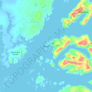
Name: Nuuk topographic map, elevation, terrain.
Location: Nuuk, Sermersooq, 3900, Greenland (64.01668 -51.89594 64.33668 -51.57594)
Average elevation: 76 m
Minimum elevation: -6 m
Maximum elevation: 1,170 m
Other topographic maps
Click on a map to view its topography, its elevation and its terrain.
Geographical Society Island
Geographical Society Island, Sermersooq, Greenland
Average elevation: 178 m