
County Offaly topographic map
Interactive map
Click on the map to display elevation.
About this map
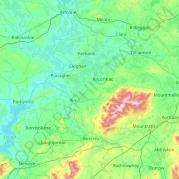
Name: County Offaly topographic map, elevation, terrain.
Location: County Offaly, Leinster, R45 X951, Ireland (52.84813 -8.08365 53.42427 -6.97776)
Average elevation: 91 m
Minimum elevation: 27 m
Maximum elevation: 512 m
Other topographic maps
Click on a map to view its topography, its elevation and its terrain.
Tuam
Tuam, Tuam Municipal District, County Galway, Connacht, Ireland
Average elevation: 40 m
Shanaghy
Shanaghy, Belmullet ED, Westport-Belmullet Municipal District, County Mayo, Connacht, Ireland
Average elevation: 18 m
Balling
Balling, Toberroe ED, Ballinasloe Municipal District, County Galway, Connacht, Ireland
Average elevation: 96 m
Tearaght Island
Tearaght Island, County Kerry, Munster, Ireland
Average elevation: 1 m
Portarlington
Portarlington, County Laois, Leinster, Ireland
Average elevation: 70 m
Finnis
Finnis, Brinny ED, The Municipal District of Bandon-Kinsale, County Cork, Munster, P72 A327, Ireland
Average elevation: 75 m
Sligo
Sligo, Sligo Municipal Borough District, County Sligo, Connacht, Ireland
Average elevation: 25 m
The Municipal District of Adare — Rathkeale
The Municipal District of Adare — Rathkeale, County Limerick, Munster, Ireland
Average elevation: 74 m
Rathdowney
Rathdowney, The Municipal District of Borris-in-Ossory — Mountmellick, County Laois, Leinster, R32 H773, Ireland
Average elevation: 100 m
Clonsilla
Ireland > County Dublin > Blanchardstown
Clonsilla, Blanchardstown-Blakestown DED 1986, Blanchardstown, Fingal, County Dublin, Leinster, Ireland
Average elevation: 63 m
Dunlewey Lough
Dunlewey Lough, Dunlewy ED, Glenties Municipal District, County Donegal, Ireland
Average elevation: 169 m
The Municipal District of Castlecomer
The Municipal District of Castlecomer, County Kilkenny, Leinster, Ireland
Average elevation: 139 m
Newfarm
Newfarm, The Rower, The Municipal District of Callan — Thomastown, County Kilkenny, Leinster, Ireland
Average elevation: 33 m
Blanchardstown
Blanchardstown, Fingal, County Dublin, Leinster, D15 KPW7, Ireland
Average elevation: 61 m
Rathmines
Ireland > County Dublin > Dublin
Rathmines, Rathmines West B Ward 1986, Dublin, County Dublin, Leinster, Ireland
Average elevation: 28 m
Louisburgh
Louisburgh, Westport-Belmullet Municipal District, County Mayo, Connacht, Ireland
Average elevation: 17 m
Ballina
Ballina, Ballina Municipal District, County Mayo, Connacht, Ireland
Average elevation: 19 m
Killarney
Killarney, Killarney Municipal District, County Kerry, Munster, Ireland
Average elevation: 57 m
Gunpoint
Gunpoint, Lowertown, West Cork, County Cork, Munster, Ireland
Average elevation: 14 m
Newbridge
Newbridge, The Municipal District of Kildare — Newbridge, County Kildare, Leinster, Ireland
Average elevation: 95 m
Ballyboden
Ballyboden, South Dublin, County Dublin, Leinster, D14 VY33, Ireland
Average elevation: 83 m
Took
Took, Modelligo, The Municipal District of Dungarvan — Lismore, County Waterford, Munster, Ireland
Average elevation: 169 m
Dún Laoghaire
Dún Laoghaire, Dún Laoghaire-Rathdown, County Dublin, Leinster, A96 T860, Ireland
Average elevation: 21 m
Powderly Lower
Ireland > County Donegal > Kildoney
Powderly Lower, Kildoney, Castlefinn ED, Lifford-Stranorlar Municipal District, County Donegal, Ulster, Ireland
Average elevation: 57 m
Thomastown
Thomastown, The Municipal District of Callan — Thomastown, County Kilkenny, Leinster, Ireland
Average elevation: 44 m
Moyle Beg
Moyle Beg, Cormeen ED, Ballybay-Clones Municipal District, County Monaghan, Ulster, Ireland
Average elevation: 135 m
Waterfall
Waterfall, Inishkenny, Municipal District of Carrigaline, County Cork, Munster, T12 CYF2, Ireland
Average elevation: 96 m
Carlingford
Carlingford, County Louth, Leinster, Ireland
Average elevation: 84 m
Camira Glebe
Camira Glebe, Rosenallis ED, The Municipal District of Borris-in-Ossory — Mountmellick, County Laois, Leinster, Ireland
Average elevation: 82 m
Saint Kevins Ward 1986
Ireland > County Dublin > Dublin
Saint Kevins Ward 1986, Dublin, County Dublin, Leinster, Ireland
Average elevation: 18 m
Letterkenny
Letterkenny, County Donegal, Ulster, Ireland
Average elevation: 92 m
Naas
Naas, The Municipal District of Naas, County Kildare, Leinster, Ireland
Average elevation: 99 m
Kilcullen
Kilcullen, Municipal District of Macroom, County Cork, Munster, Ireland
Average elevation: 216 m
Dunmore
Dunmore, Tuam Municipal District, County Galway, Connacht, Ireland
Average elevation: 63 m
Jerpoint Church
Jerpoint Church, The Municipal District of Callan — Thomastown, County Kilkenny, Leinster, Ireland
Average elevation: 94 m
Clara
Clara, Clara ED, The Municipal District of Tullamore, County Offaly, Leinster, Ireland
Average elevation: 62 m
Cliffs of Moher
Cliffs of Moher, Ballysteen ED, West Clare Municipal District, County Clare, Munster, Ireland
Average elevation: 55 m
Listowel Municipal District
Listowel Municipal District, County Kerry, Munster, Ireland
Average elevation: 67 m
The Glen
Ireland > County Cork > Cork
The Glen, Dublin Hill, The Glen B, Cork, County Cork, Munster, T23 D437, Ireland
Average elevation: 57 m