
Strathmore (town) topographic map
Click on the map to display elevation.
About this map
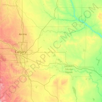
Name: Strathmore (town) topographic map, elevation, terrain.
Location: Strathmore (town), Alberta, T1P 1K2, Canada (50.35036 -114.09686 51.75036 -112.69686)
Average elevation: 988 m
Minimum elevation: 668 m
Maximum elevation: 1,966 m
Other topographic maps
Click on a map to view its topography, its elevation and its terrain.
Moraine Lake
Canada > Alberta > Improvement District No. 9
Moraine Lake is a snow and glacially fed lake in Banff National Park, 14 kilometres (8.7 mi) outside the village of Lake Louise, Alberta, Canada. It is situated in the Valley of the Ten Peaks, at an elevation of approximately 1,884 metres (6,181 ft). The lake has a surface area of 50 hectares (120 acres).
Average elevation: 2,101 m
Lois Hole Centennial Provincial Park
Canada > Alberta > St. Albert > St. Albert
The park is situated on the shores of Big Lake, on the lower course of the Sturgeon River, at an elevation of 660 m (2,170 ft). It is maintained by Alberta Tourism, Parks and Recreation and was established on April 19, 2005, on lands designated in 1999 as Big Lake Natural Area (part of the Special Places…
Average elevation: 671 m
Johnston Creek
Canada > Alberta > Improvement District No. 9
Johnston Creek originates north of Castle Mountain in a glacial valley southwest of Badger Pass and south of Pulsatilla Pass, at an elevation of 2,500 meters (8,200 ft). The creek flows southeast between Helena Ridge and the Sawback Range, and then south through a gorge known as Johnston Canyon. The stream…
Average elevation: 1,771 m
Empress
It is located on the southern bank above the Red Deer River, 9 km (5.6 mi) northwest of the confluence of Red Deer River and South Saskatchewan River, at an elevation of 650 metres (2,130 ft). It is connected to Buffalo Trail by Highway 899 and Highway 562.
Average elevation: 603 m