
Chiti topographic map
Interactive map
Click on the map to display elevation.
About this map
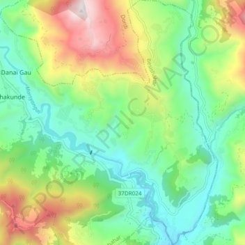
Name: Chiti topographic map, elevation, terrain.
Location: Chiti, Besishahar, लमजुङ, Gandaki, Népal (28.16409 84.40595 28.23013 84.45838)
Average elevation: 947 m
Minimum elevation: 555 m
Maximum elevation: 1,721 m
Other topographic maps
Click on a map to view its topography, its elevation and its terrain.
Bahundanda
Bahundanda, Bahundada, Marsyangdi, लमजुङ, Gandaki, 36000, Népal
Average elevation: 1,415 m
Ngadi Lamjung
Ngadi Lamjung, Bhulbhule, Marsyangdi, लमजुङ, Gandaki, 36000, Népal
Average elevation: 1,402 m
Besisahar
Népal > लमजुङ > Besishahar
Besisahar, Besishahar, लमजुङ, Gandaki, 33600, Népal
Average elevation: 1,163 m
Bahundanda
Népal > लमजुङ > Bahundada > Bahundanda
Bahundanda, Bahundada, Marsyangdi, लमजुङ, Gandaki, Népal
Average elevation: 1,276 m