
Make a donation
Gear up for your next adventure:
As an Amazon Associate, this site earns from qualifying purchases at no extra cost to you.
Frasdorf topographic map
Click on the map to display elevation.
Make a donation
Gear up for your next adventure:
As an Amazon Associate, this site earns from qualifying purchases at no extra cost to you.
About this map
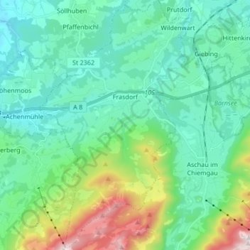
Name: Frasdorf topographic map, elevation, terrain.
Location: Frasdorf, Landkreis Rosenheim, Bayern, 83112, Deutschland (47.74722 12.23599 47.83732 12.34035)
Average elevation: 729 m
Minimum elevation: 497 m
Maximum elevation: 1,566 m
Make a donation
Gear up for your next adventure:
As an Amazon Associate, this site earns from qualifying purchases at no extra cost to you.
Other topographic maps
Click on a map to view its topography, its elevation and its terrain.
Geigelstein
Deutschland > Bayern > Landkreis Rosenheim > Aschau im Chiemgau
1991 wurden große Flächen des Geigelstein als Naturschutzgebiet Geigelstein ausgewiesen. Das NSG Geigelstein hat eine Größe von 3135 Hektar und liegt zum Teil im Landkreis Rosenheim mit der Gemeinde Aschau sowie im Landkreis Traunstein mit der Gemeinde Schleching. Mit einem der größten Schutzgebiete auf…
Average elevation: 1,443 m
Make a donation
Gear up for your next adventure:
As an Amazon Associate, this site earns from qualifying purchases at no extra cost to you.
Kampenwand-Hauptgipfel
Deutschland > Bayern > Landkreis Rosenheim > Aschau im Chiemgau
Average elevation: 1,272 m
Make a donation
Gear up for your next adventure:
As an Amazon Associate, this site earns from qualifying purchases at no extra cost to you.
Großhöhenrain
Deutschland > Bayern > Landkreis Rosenheim > Feldkirchen-Westerham
Average elevation: 568 m
Make a donation
Gear up for your next adventure:
As an Amazon Associate, this site earns from qualifying purchases at no extra cost to you.
Make a donation
Gear up for your next adventure:
As an Amazon Associate, this site earns from qualifying purchases at no extra cost to you.
Make a donation
Gear up for your next adventure:
As an Amazon Associate, this site earns from qualifying purchases at no extra cost to you.
Make a donation
Gear up for your next adventure:
As an Amazon Associate, this site earns from qualifying purchases at no extra cost to you.
Hochrunstfilze
Deutschland > Bayern > Landkreis Rosenheim > Raubling > Nicklheim
Average elevation: 468 m
Staffelstein
Deutschland > Bayern > Landkreis Rosenheim > Aschau im Chiemgau
Average elevation: 1,258 m
Make a donation
Gear up for your next adventure:
As an Amazon Associate, this site earns from qualifying purchases at no extra cost to you.
Thalham
Deutschland > Bayern > Landkreis Rosenheim > Bruckmühl > Mittenkirchen
Average elevation: 538 m
Make a donation
Gear up for your next adventure:
As an Amazon Associate, this site earns from qualifying purchases at no extra cost to you.
Hohenaschau
Deutschland > Bayern > Landkreis Rosenheim > Aschau im Chiemgau
Aschach | Aschau im Chiemgau | Attich | Aufham | Außerkoy | Außerwald | Bach | Berg | Brückl | Bucha | Einfang | Engerndorf | Fellerer | Göttersberg | Grattenbach | Grenzhub | Grünwald | Hainbach | Haindorf | Hammerbach | Hintergschwendt | Hohenaschau im Chiemgau | Höhenberg | Hub | Huben | Innerkoy |…
Average elevation: 863 m
Make a donation
Gear up for your next adventure:
As an Amazon Associate, this site earns from qualifying purchases at no extra cost to you.
Make a donation
Gear up for your next adventure:
As an Amazon Associate, this site earns from qualifying purchases at no extra cost to you.
Hochries
Deutschland > Bayern > Landkreis Rosenheim > Samerberg
Der Gipfel ist per Bahn von Grainbach aus zu erreichen. Vom Ort geht ein Sessellift zur Mittelstation auf 920 m Höhe. Von dort führt eine Kabinenbahn auf den Gipfel. Die Hochries ist als Rosenheimer „Hausberg“ beliebt bei Wanderern sowie insbesondere Gleitschirm- und Drachenfliegern.
Average elevation: 1,223 m
Make a donation
Gear up for your next adventure:
As an Amazon Associate, this site earns from qualifying purchases at no extra cost to you.
Vagen
Deutschland > Bayern > Landkreis Rosenheim > Feldkirchen-Westerham
Vagen ist ein Ortsteil der Gemeinde Feldkirchen-Westerham im Landkreis Rosenheim. Das Pfarrdorf liegt auf einer Höhe von 525,7 m ü. NN. Vor der Gemeindegebietsreform 1972 war Vagen eine eigenständige Gemeinde.
Average elevation: 564 m
Kleiner Traithen
Deutschland > Bayern > Landkreis Rosenheim > Kiefersfelden
Average elevation: 1,336 m
Make a donation
Gear up for your next adventure:
As an Amazon Associate, this site earns from qualifying purchases at no extra cost to you.
Make a donation
Gear up for your next adventure:
As an Amazon Associate, this site earns from qualifying purchases at no extra cost to you.
Make a donation
Gear up for your next adventure:
As an Amazon Associate, this site earns from qualifying purchases at no extra cost to you.
Make a donation
Gear up for your next adventure:
As an Amazon Associate, this site earns from qualifying purchases at no extra cost to you.
Make a donation
Gear up for your next adventure:
As an Amazon Associate, this site earns from qualifying purchases at no extra cost to you.
Urschalling
Deutschland > Bayern > Landkreis Rosenheim > Prien am Chiemsee > Bach
Average elevation: 563 m
Make a donation
Gear up for your next adventure:
As an Amazon Associate, this site earns from qualifying purchases at no extra cost to you.
Fachendorf
Deutschland > Bayern > Landkreis Rosenheim > Bad Aibling > Berbling
Average elevation: 527 m
Make a donation
Gear up for your next adventure:
As an Amazon Associate, this site earns from qualifying purchases at no extra cost to you.
Kleinhöhenrain
Deutschland > Bayern > Landkreis Rosenheim > Feldkirchen-Westerham > Großhöhenrain
Average elevation: 561 m
Stetten
Deutschland > Bayern > Landkreis Rosenheim > Prien am Chiemsee > Atzing
Average elevation: 583 m
Make a donation
Gear up for your next adventure:
As an Amazon Associate, this site earns from qualifying purchases at no extra cost to you.
Feldolling
Deutschland > Bayern > Landkreis Rosenheim > Feldkirchen-Westerham
Average elevation: 560 m
Make a donation
Gear up for your next adventure:
As an Amazon Associate, this site earns from qualifying purchases at no extra cost to you.
Happinger See
Deutschland > Bayern > Landkreis Rosenheim > Rosenheim > Pfraundorf
Average elevation: 451 m
Make a donation
Gear up for your next adventure:
As an Amazon Associate, this site earns from qualifying purchases at no extra cost to you.
Make a donation
Gear up for your next adventure:
As an Amazon Associate, this site earns from qualifying purchases at no extra cost to you.
Kleinholzhausen
Deutschland > Bayern > Landkreis Rosenheim > Raubling > Großholzhausen
Average elevation: 506 m
Make a donation
Gear up for your next adventure:
As an Amazon Associate, this site earns from qualifying purchases at no extra cost to you.
Walpersdorf
Deutschland > Bayern > Landkreis Rosenheim > Feldkirchen-Westerham > Unterlaus
Average elevation: 564 m
Heufeld
Deutschland > Bayern > Landkreis Rosenheim > Bruckmühl
Heufeld ist ein Gemeindeteil des Marktes Bruckmühl im Landkreis Rosenheim in Oberbayern. Der Gemeindeteil ist mit den Jahren komplett mit dem Gemeindeteil Bruckmühl zusammengewachsen und liegt auf einer Höhe von 492 m ü. NN.
Average elevation: 493 m
Make a donation
Gear up for your next adventure:
As an Amazon Associate, this site earns from qualifying purchases at no extra cost to you.
Grainbach
Deutschland > Bayern > Landkreis Rosenheim > Samerberg
Die Gemeindeteile von Samerberg liegen östlich des Inns räumlich verstreut auf einem etwa sieben Kilometer langen hügeligen Hochplateau in ca. 600 bis 750 m Höhe ü. NN zwischen Nußdorf im Inntal im Südwesten und Frasdorf an der Autobahn A 8 München–Salzburg im Nordosten. Das Kirchdorf Grainbach…
Average elevation: 715 m
Make a donation
Gear up for your next adventure:
As an Amazon Associate, this site earns from qualifying purchases at no extra cost to you.